- Stručný popis
-
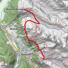
Piz Lunghin forms an important junction in the geography of the Alps. At this point three water cuts meet, which direct the runoff of precipitation on three sides: eastward to the Danube, northward to the Rhine, and southward to the Po.
- Obtiažnosť
-
stredná
- Hodnotenie
-
- Trasa
-
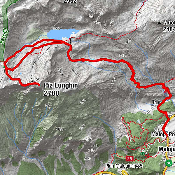
Maloja (1.809 m)Maloja Posta0,0 kmPila0,6 kmInn1,7 kmPiz Lunghin (2.780 m)5,7 kmPass Lunghin (2.645 m)6,6 kmInnquelle6,9 kmInn9,8 kmPila10,9 kmMaloja Posta11,5 kmMaloja (1.809 m)11,5 km
- Najlepšia sezóna (ročné obdobie)
-
janfebmaraprmájjúnjúlaugsepoktnovdec
- Najvyšší bod
- 2.771 m
- Cieľová destinácia
-
Maloja
- Profil nadmorskej výšky
-
 © outdooractive.com

- Autor
-
Prehliadka The Lunghin používa outdooractive.com na stránke ..
GPS Downloads


Všeobecné informácie
Kultúra/Historické stránky
S výhľadmi
Ďalšie prehliadky v regiónoch
-
Veltlin / Valtellina
851
-
Val Bregaglia Engadin
468
-
Maloja
245