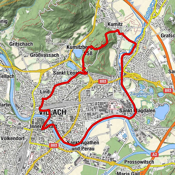
Villach - Kumitzberg - Brandenburg

Logo Villach - Kumitzberg - Brandenburg
Údaje o túre
12,4km
484 - 638m
Vzdialenosť
124hm
Výstup
03:30h
 
Trvanie
Stručný popis

einfache Wanderung mit leichtem Anstieg
Gesamtstrecke ca. 12 km, Gehzeit ca. 3 1/2 Std.

Hodnotenie
Technika
Kondícia
Krajina
Zážitok
Trasa
Innere Stadt
0,1 km
Villach (501 m)
0,5 km
Lind
1,2 km
St. Leonhard
2,4 km
Kumitzberg (658 m)
4,3 km
Gasthof Brandenburg
4,4 km
Kumitz
5,4 km
Urlaken
5,8 km
St. Magdalen
8,7 km
Wasenboden
11,0 km
Spielplatz Freihausplatz
12,2 km
Innere Stadt
12,4 km
Villach Mosque
12,4 km
Duomo San Giacomo
12,4 km
Najvyšší bod
638 m

Zvyšok/Ústup

diverse Einkehrmöglichkeiten in der Villacher Innenstadt


Celkové hodnotenie

5

0

%

4

0

%

3

0

%

2

0

%

1

0

%

Chyba
Vyskytla sa chyba. Prosím, skúste to znova.
Ďakujeme vám za vašu recenziu

Hodnotenie bolo vymazané

GPS Downloads
  • GPX GPS Exchange Format (XML)
  • KML Google Earth, Google Maps
Kódy QR na stiahnutie pre mobilné telefóny

Podmienky na trase

Asfalt
Štrk
Lúka
Les
Skala
Exponovaný

Najobľúbenejšie túry v okolí

Gerlitzen- Hüttersteig

stredná
5,07km | 971hm | 02:00h

Seppl Hütte Circuit

stredná
8,17km | 436hm | 02:45h

Mirnock vom Osten

ľahká
8,82km | 627hm | 04:30h

Dobratsch

4,54km | 509hm | 03:30h