


Via Francigena for all | Villar Focchiardo - Avigliana section
The intense flow of people along the Via Francigena produced, during the Middle Ages in the Susa Valley, a circulation and exchange of knowledge that contributed to the development of a European cultural...
The intense flow of people along the Via Francigena produced, during the Middle Ages in the Susa Valley, a circulation and exchange of knowledge that contributed to the development of a European cultural vitality and international renown identifiable today with the Abbey of Novalesa and the Sacra di San Michele, town centers that were market seats or places of transit and mandatory tolls such as Susa, Bussoleno, Avigliana, and Oulx.
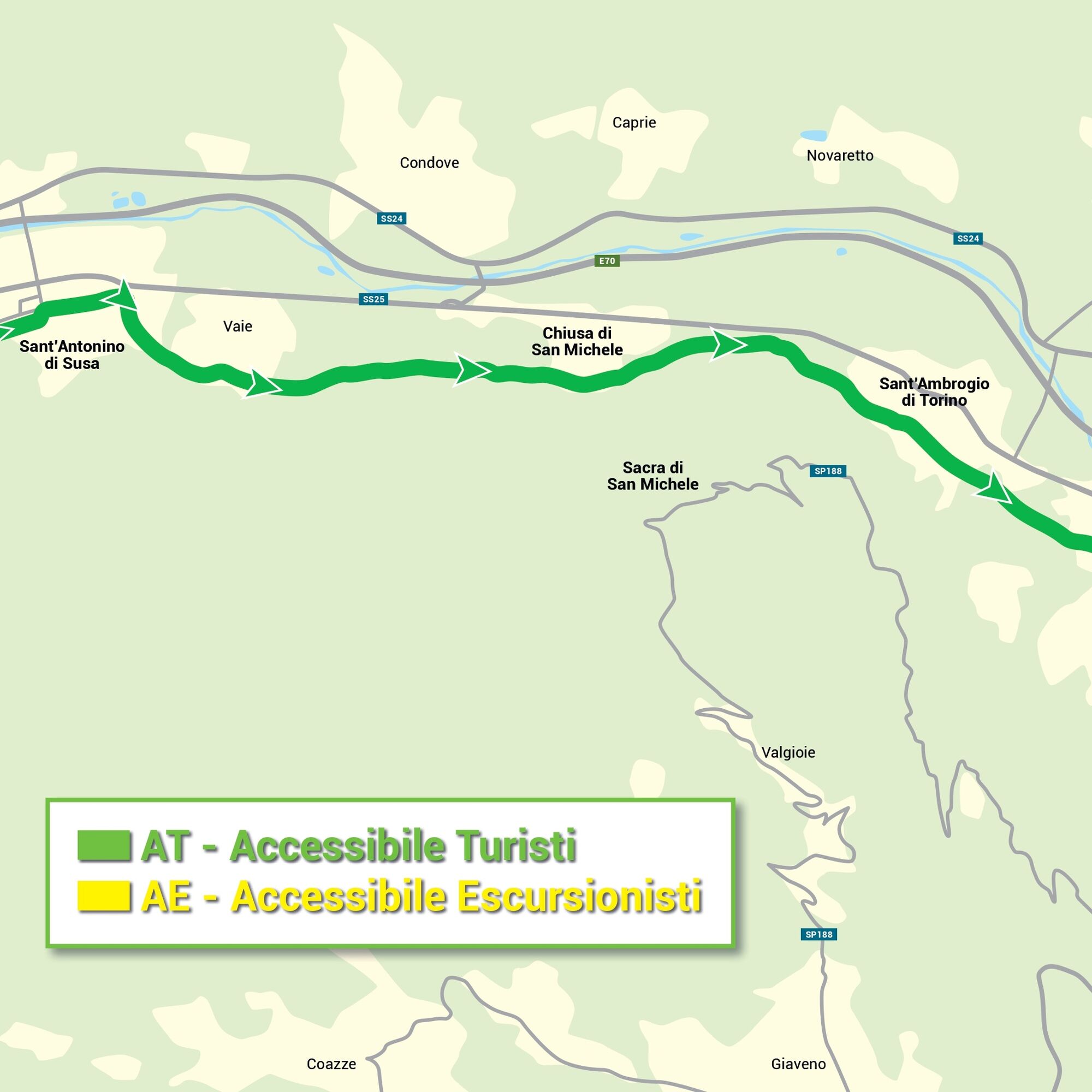
In the stretch considered by the "Via Francigena for all" project, in just over 16 kilometers, all flat, the villages of Villar Focchiardo, Sant'Antonino di Susa, Vaie, Chiusa di San Michele, S.Ambrogio di Torino are crossed to reach Avigliana: a city with a splendid medieval historic center and two lakes.

The section starts from the inhabited center of Villar Focchiardo with the Parish Church of Santa Maria Assunta, an example of 18th-century Baroque typical of the Savoy court, which testifies to the close bond with the commissioning Carroccio family. The town, one of the most important producers of IGP Chestnuts, is home to the historic Chestnut Festival.
At Cascina Roland, a 16th-century fortified house now hosting a "bike hotel" accommodation, an accessible rest point for disabled people is installed.
Reaching the hamlet of Comba, the Ancient Strada di Francia is followed to Sant’Antonino di Susa, where the main square is dominated by the imposing facade of the Parish Church of Saint Antonino Martyr, one of the oldest churches in the valley and seat of the hospitaller canons of Saint Antonino of the Noble Valley: the architectural structure features typical 11th-century elements, such as the bell tower, and is enriched by 14th-century fresco cycles.
Continuing along the same street, the path leads to Vaie, known for the typical production of the canestrello, a fragrant biscuit baked on special tong irons. An interesting archaeological and naturalistic path leads to the San Pancrazio Sanctuary (11th century) and ends at the Experimental Archaeology Museum.
The Ancient Strada di Francia then leads to Chiusa San Michele: its name is linked to the remains of the Lombard Locks, the scene of a clash between Charlemagne and Desiderius, and to its dependency on the Sacra di San Michele (983-987 AD), which dominates the town from Mount Pirchiriano. To the right of the 18th-century Parish Church of Saint Peter the Apostle, between cultivated fields and woods, runs the historic mule track, partially bordered by dry stone walls, which reaches in about 2 hours the Clusian abbey, a symbol monument of Piedmont.
Not far from the church of Saint Peter, there is a refreshment point at the Bicigrill San Michele: from here the stretch is entirely on a cycle path, bordered by closed bars with reduced access for pedestrians and cyclists, also compatible with the width of the joelette. Passing the Chamois Pond (a place born as a naturalistic observatory and where another refreshment point is present) and after the start of the suggestive "Carlo Giorda" Via Ferrata, you enter the historic center of Sant’Ambrogio di Torino on a paved street, equipped with narrow sidewalks: the place is worth a stop for the city walls, the Abbey Castle, Church of San Giovanni Vincenzo, Maglificio Bosio, and during the reenactment of the Battle of the Locks in June and the Meliga Day festival held on the last weekend of September celebrating the typical corn flour biscuit (meliga).
At the roundabout, turn right onto a lightly trafficked residential street but without sidewalks, continuing on the Ancient Strada di Francia. The route then crosses the industrial area between Sant’Ambrogio and Avigliana where the cycle path is present, continuing along Via Galinier and Via XX Settembre: we are in the medieval historic center of Avigliana and from here, climbing the Via di Porta Ferrata (steep and rather steep), it is possible to reach the ancient heart of Piazza Conte Rosso dominated by the castle ruins.
Then descending Via Umberto I and following Corso Laghi towards Trana, you reach the Small Lake and the second accessible area of the “Via Francigena for all” project.
Áno
Áno
Áno
MAP LEGEND FOR ACCESSIBILITY WITH JOELETTE OR OTHER OFF-ROAD AID:
AT Accessible Tourists (green section)
Routes on cart tracks, dirt roads, and grassy trails. Characterized by modest slopes (less than 8%), width (greater than 1.5 meters), contained altitude differences (less than 150 m), length under 3 km.
They generally have a uniform and smooth surface, without artificial or natural steps, no exposed points or tight curves that may make maneuvers difficult.
Note: although it is possible to overcome small slopes independently with a self-propelled wheelchair, for safety it is never recommended to travel these routes alone.
AE Accessible Hikers (yellow section)
Routes on evident paths and paved mule tracks. Characterized by moderate slopes (under 16%), width between one and one and a half meters, altitude differences under 300 meters, length from 3 to 6 km, uneven surface, few and/or modest artificial or natural steps easily overcome by an off-road aid (joelette), absence of major obstacles, no exposed points and/or tight curves that could make maneuvers difficult.
Note: regardless of route length, it is necessary to consider the time required to complete the hike in relation to the difficulties.
All the details of the accessibility assessments for the route at this link:
https://www.google.com/maps/d/u/1/viewer?mid=1c1ZaVXZhxc25UAHNcKv3n2qmp5mf0vg&ll=45.10176729902118%2C7.329271640728883&z=13
https://www.valdisusaturismo.it/come-arrivare/
TRAIN
From Turin, trains to the Susa Valley are frequent. The service is scheduled with hourly trains both for the Susa-Turin and Bardonecchia–Turin routes, excluding Sundays and holidays when departures are at one-hour intervals. The train service crosses and stops in many localities in the Susa Valley.
Info
Info: http://www.sfmtorino.it/http://www.trenitalia.com/
BUS
The Susa Valley is connected by a dense network of bus services.
GTT buses (extra-urban lines) run to Avigliana, while SADEM buses connect almost all towns and villages in the Susa Valley.
Info
Info: www.comune.torino.it/gtt/www.sadem.it
The Via Francigena accessible to everyone: with the Piedmont Region project “Via Francigena for all”, a pilot project was launched to offer an inclusive experience to people with motor, cognitive-intellectual, and sensory disabilities, the elderly, families with small children, up to people with chronic health problems, on two Piedmontese stretches of the historic European path.
On the Canavese route from Ivrea to Viverone and the Susa Valley route from Villar Focchiardo to Avigliana (and surrounding territories with their related cultural, naturalistic, sports, and food and wine tourism offer), accommodation and hospitality for disabled people have been enhanced and a light infrastructure was created with the installation of 3 accessible rest areas and visual-tactile panels in each of the 12 municipalities crossed.
Furthermore, several Romanesque churches on the two stretches of the path are visitable autonomously through the “Churches with Open Doors” app and are equipped with multisensory audio and video panels in sign language, videos in LIS (Italian Sign Language), and alternative augmentative communication cards narrating the sites and the works housed inside.
Accessible rest areas of Villar Focchiardo and Avigliana: they offer shelter and allow easy and intuitive use for everyone (parking, bike or electric wheelchair charging, bike repair kit) while the panels feature raised content that can be explored by those with visual and hearing disabilities, with combinations of visual, auditory, and tactile information.
Multisensory signs: in every municipality along the route, the panels feature raised content that can be explored by those with visual and hearing disabilities, with combinations of visual, auditory, and tactile information.
Churches with open doors: collaboration with the Ecclesiastical Region's project allows autonomous visits, 365 days a year, to ecclesiastical cultural assets through the free app of the same name, with the opening to the public of 20 new places along the Via Francigena now accessible to people with sensory and cognitive disabilities through multisensory audio and video panels in sign language, videos in LIS (Italian sign language), and alternative augmentative communication cards narrating the sites and works housed inside.
Info: https://www.cittaecattedrali.it/
Along the route and nearby, it is possible to visit with these methods:
Chapel of Maddalena in Novalesa Susa Cathedral Madonna delle Grazie in Foresto (Bussoleno) Count's Chapel in San Giorio (accessible to motor-disabled people via mobile stairlift) Chapel of Saint Stefano in Giaglione Church of Saint Catherine in Chiomonte Oratory of Jesus in Avigliana Madonna della Stella in Pianezza Chapel of Saint Sebastian in PianezzaVillar Focchiardo: located at the mouth of the Gravio valley, the old part - la Villa - develops on a promontory, and the hamlets in the mountainous area are rich in IGP Chestnut woods. To see: Church of Santa Maria Assunta, Banda Charterhouse and Cascina Roland, a 16th-century fortified house. Famous is the Valsusino Chestnut Festival.
Sant’Antonino di Susa: developed in the Middle Ages as the village of Sant’Agata, it took the current name from the canons who offered pilgrim hospitality. To see: Church of Saint Antonino Martyr with medieval external frescoes, the hamlet of Cresto, Castel Billia, and the mareschi.
Vaie: was one of the first Neolithic settlements in Valsusa, as well as a testimony of migrations and trade in the Middle Ages. To see: the Prehistory Laboratory Museum with the archaeological-naturalistic path, the Sanctuary of San Pancrazio, and the Vaie Canestrello Festival.
Chiusa di San Michele: at the narrowest point of the valley, it is recalled in Italian history for the “Battle of the Chiuse” between the Lombards of Desiderius and the Franks of Charlemagne. To see: Church of St. Peter the Apostle, Chapel of St. Joseph, Lombard locks, and the Ethnographic Museum.
Sant’Ambrogio di Torino: its development is linked to the events of the legendary Sacra di San Michele dominating it from Monte Pirchiriano. To see: city walls, the Abbey Castle, Church of San Giovanni Vincenzo, Maglificio Bosio, Meliga Day festival, and the "Carlo Giorda" Via Ferrata.
Avigliana: surrounded by morainic hills embracing the two lakes of the Natural Park, it has a medieval historic center with ancient noble palaces, arcades, and frescoes. To see: Piazza Conte Rosso, the Arduinic Castle, churches of San Giovanni, San Pietro, and Santa Maria Maggiore, and the Sanctuary of Madonna dei Laghi.
To taste: Salame Mica, Toma from lait brusc, mountain potatoes, honey, Canestrelli from Vaie and San Giorio, meliga pastries, Susa focaccia, chestnuts, Valsusa apples, Valsusa DOC wines, craft beer, and herbal liquors.
Obľúbené výlety v okolí
-
4,7
On the summit of the magical Musiné
svetloTuristika 6,94 km -
Avigliana Lakes - Easy route, ideal for families with children
svetloTuristika 9,25 km -
CASELETTE - Monte Musiné
strednáTuristika 7,52 km -
COLLE DEL LYS Partisan Trail
strednáTuristika 11,6 km -
5,0
Unspoiled woods and ancient hamlets in Valsangone - Selvaggio Loop - Bagaggera
svetloTuristika 9,08 km -
Easy route - Monte Cuneo (Moncuni) Loop route from Reano
svetloTuristika 7,97 km -
COLLE DEL LYS Monte Arpone loop
svetloTuristika 4,50 km -
A walk in the Megalithic - The Menhirs of Pietraborga - Direct route from the Torrioni
strednáTuristika 9,30 km -
4,0
The Giro dell'Orsiera G.O. Trail Stage 1: Molè - Rifugio Balma
strednáTuristika 4,52 km -
COLLE DEL LYS Alpine Loop
strednáTuristika 15,3 km
Turistika a stopovanie


Nenechajte si ujsť ponuky a inšpiráciu na ďalšiu dovolenku
Vaša e-mailová adresa bol pridaný do poštového zoznamu.