


Otterberg - circular hiking trail 3 - Wallonen circular hiking trail
Parking lot on Johannisstraße, 67697 Otterberg (opposite Gaststätte Kraus) - Weiherstraße (northeast) - Ölmühle - Badweiher - Neumühler Hang - Schweißberg - Drehenthalerhof - Kahlenberg - Schweißberg -...
Parking lot on Johannisstraße, 67697 Otterberg (opposite Gaststätte Kraus) - Weiherstraße (northeast) - Ölmühle - Badweiher - Neumühler Hang - Schweißberg - Drehenthalerhof - Kahlenberg - Schweißberg - Otterbachtal - Neumühle - Badweiher - Ölmühle - Weiherstraße - Parking lot on Johannisstraße, 67697 Otterberg (opposite Gaststätte Kraus)
UFFBASSE! - Campaign for considerate coexistence in nature
- Always behave thoughtfully, friendly, and considerate to everyone you meet on the way.
- Pay attention to nature, do not destroy plants and always stay on the paths.
- Remember to take a garbage bag for the trail and take your trash back home.
- Please always keep your dog on a leash. Other visitors and animals thank you.
- Observe all path closures for your own safety. Even on weekends.
- Park only in designated parking spaces. Leave room for emergency routes and agricultural machinery.
- Give priority to agricultural and forestry traffic.


The starting point is the parking lot on Johannisstraße at the hiking trail sign. We walk along the Otterbach stream through the Weihergärten. We follow local markings No. 3+5 to the new waterworks. There we turn right, then immediately behind the waterworks turn left towards the swimming pool. After a few meters, we reach the Ölmühle. Soon we arrive at the sports center and walk around our swimming pool. We continue until just before the junction with the L 387 and turn right at the edge of the forest. We do not take the entry directly after the Wallonenhof. Below the Neumühler-Hang forest section, we hike along the so-called Philosophenweg. To the left of this path is the Neumühle. The marked hiking trail now reaches the connecting road to Drehenthalerhof (K 35). Slightly uphill, parallel to the road, we walk along the forest path to Drehenthalerhof. At the first houses of the farm, we cross the K 35 to the left and follow the forest road westward. Our familiar No. 3 is now joined by the path sign “red stripe,” marking the international long-distance hiking trail – Donnersberg/Pfalz – Donon/Elsaß. After about 40 m, we follow the forest road that turns right towards Potzbach. After another 500 m, about 150 m west of the path at marking No. 7, lie the so-called megalithic graves.
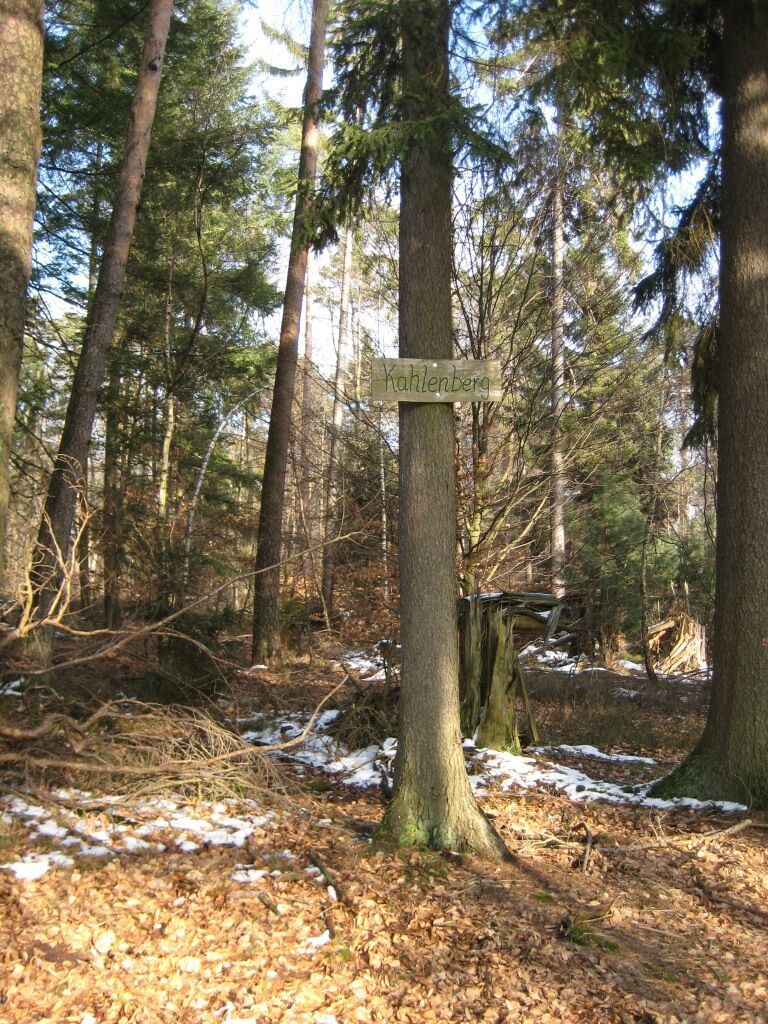
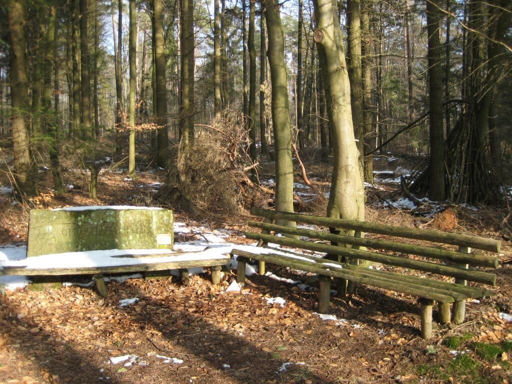
We continue our way until, after 1300 m, the forest road and the “red stripe” marking separate from marking No. 3. The path turns 90° right. At the turn, we see the dedication stone of Otto Schäffler with a seating area. The path leads through the Kahlenberg. After about 200 m, we walk along a forest path over the western spur of the Einsiedler Berg into the village street “Rabenthal” of Drehenthalerhof. From the village center at the fountain, we walk along Glashütterstraße to the cemetery. Meanwhile, the path sign “green-yellow stripe” – marking the long-distance trail Kirchheimbolanden – Otterberg – Hirschthal/border – joined our marking. Both signs guide us on the ridge path over Schweisberg (334 m) down to the Wallonengaststätte about 2 km away. At this inn, we can rest a bit and enjoy some good food or drinks. Then we continue past the swimming pool. We return to Weiherstraße and back to the starting point.
Áno
Áno
For our hiking routes, we recommend the following standard equipment:
- Sturdy footwear
- Weather-appropriate clothing
- Sun and rain protection
- Adequate supply of food and drinks, as there are not always places to eat or shop open.
- Even though the paths are very well marked throughout, it is advisable for safety reasons to always carry a suitable
hiking map, so that you can quickly find a safe area, for example, in case of thunderstorms or emergencies.
- Hiking poles recommended.
General note:
Especially in autumn, note that fallen leaves on the ground can conceal unevenness, roots, stones, or holes in the path. After thunderstorms or heavy rain, trees may still fall or branches may drop afterward. In adverse weather conditions, natural paths may have muddy and slippery sections. Not all rocks or cliffs are secured with ropes or railings. Surefootedness is required in places. You must expect such path impairments when hiking. If you consider certain sections impassable, you should bypass them.
NOTE:
We strive to announce all closures caused by forestry work or hunting associations on this platform. Nevertheless, there are situations where hiking trails are closed and we may not have been informed. If you unexpectedly encounter a closure or detour, please observe the instructions for your own safety.
The distance to the larger cities is:
Kaiserslautern 8 kilometers Saarbrücken (airport) 70 kilometers Frankfurt (airport) 140 kilometers Cologne - Bonn (airport) 240 kilometersComing from Saarbrücken:
Access via the A6 exit Kaiserslautern-West (Exit No. 15), direction Lauterecken/Weilerbach. Take the 2nd exit on L367 towards Otterbach. From Otterbach, it is about 3 kilometers to Otterberg.
Coming from Mannheim:
Access via the A6 exit Enkenbach-Alsenborn (Exit No. 17). Follow the signs in Enkenbach-Alsenborn.
Coming from Frankfurt / Mainz:
Access via the A63 exit Sembach (Exit No. 14). Via Baalborn to Otterberg. About 8 kilometers from the highway.
More information at www.vrn.de.
Coordinates: 49° 30' 16" N / 7° 46' 20"
Tourist Information Otterbach-Otterberg
Hauptstraße 54, 67697 Otterberg
Phone: 06301 / 607800
Website:
Email:
You can request the host directory as a *.pdf file via one of the following addresses:
tourist-info@otterbach-otterberg.de
The paths were created by www.pwv-otterberg.de.
On the hike, we pass the Ölmühle. This is a former agricultural estate with facilities for processing oil fruits. The operation of the mill was already approved by the Palatinate Count Johann Casimir on Michaelmas 1581.
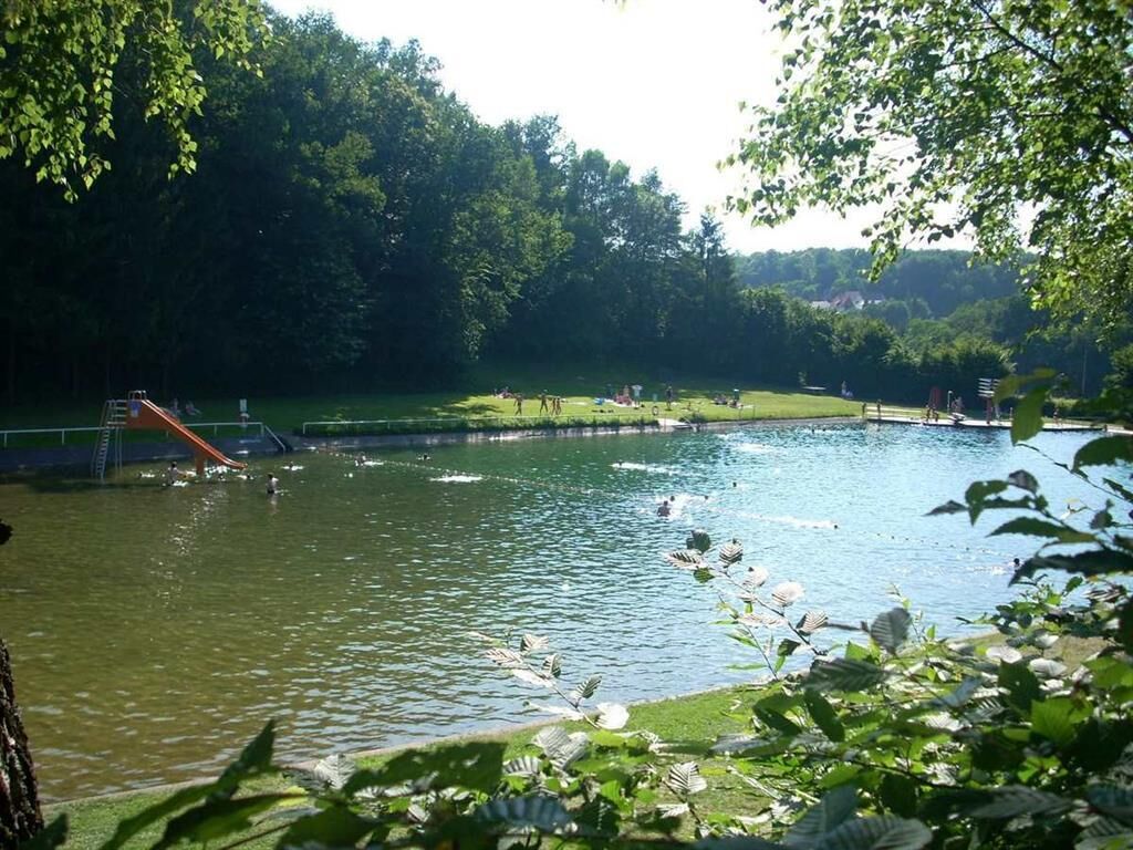
Our swimming pool is a pure natural pool, fed only by our clean water.
On the trail route, we also pass near a sandstone quarry. The sandstone quarry is owned by the forestry department. Among other things, the stones for the monument on the Heiligenmoschelerberg were quarried here in 1933.
We pass the megalithic graves (burial mounds). These are prehistoric burial mounds.
We also hike through Drehenthalerhof. Drehenthalerhof traces back to a former “glassworks”. At the beginning of the 18th century, glass production started here and stopped again in the mid-19th century. Once strongly agricultural, the annex is now a residential area.
Obľúbené výlety v okolí
-
Hinkelsteinweg - complete route
strednáTuristika 41,7 km -
Teufelstour - Olsbrücken
ťažkéTuristika 15,1 km -
4,0
Otterberg - Circular Hiking Route 5 - Springs Circular Hiking Route
svetloTuristika 6,91 km -
Palatinate Ridgeway Stage 02 Dannenfels - Bastenhaus
strednádiaľková pešia trasa 15,2 km -
Otterberg - Hinkelsteinweg (Southern Route)
strednáTuristika 21,8 km -
Pfälzer Höhenweg complete route
ťažkédiaľková pešia trasa 115,8 km -
Katzweiler - mill circular hiking trail
svetloTuristika 13,1 km -
Pfälzer Höhenweg Stage 01 Winnweiler-Dannenfels
strednádiaľková pešia trasa 16,6 km -
Katzweiler - Humberg-Tour (Rundweg)
ťažkéTuristika 13,0 km -
Otterbach - Waldforscher path in Himmelreich
svetloTematická trasa 2,59 km
Turistika a stopovanie


Nenechajte si ujsť ponuky a inšpiráciu na ďalšiu dovolenku
Vaša e-mailová adresa bol pridaný do poštového zoznamu.