"alpannonia" - feeder: Wenigzell - St. Jakob im Walde - Hochwechsel


© Oststeiermark Tourismus - Birgit Kandlbauer

© Oststeiermark Tourismus - Birgit Kandlbauer

© Oststeiermark Tourismus - Tourismusverband Oststeiermark

© Oststeiermark Tourismus - TV Jofglland-Waldheimat

- Stručný popis
-
From the UNESCO World Heritage site of Semmering or the high-altitude health resort of Fischbach to the edge of the Pannonian plain near Köszeg, a path full of variety and attractions of nature leads: alpannonia®.
Or you can start the alpannonia trail in the fairytale village of Wenigzell. From there, the "power trail" continues to the neighboring community of St. Jakob im Walde. Across the hilly landscape, the trail then continues to the Hochwechsel. From there you can then join the main alpannonia trail.
- Obtiažnosť
-
ťažká
- Hodnotenie
-
- Trasa
-
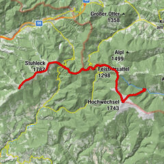
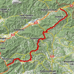
WenigzellGasthaus Kristoferitsch0,0 kmGH Lueger5,9 kmSt. Jakob im Walde6,2 kmPfarrkirche Hl. Jakobus der Ältere6,3 kmKaltenegg7,5 kmBühlhofer Höhe11,4 kmBlasenkogel (1.313 m)12,8 kmBärengrube13,4 kmRabl-Kreuz-Hütte18,1 kmKaltwiesen Hütte20,2 kmHochwechsel (1.743 m)24,3 kmWetterkoglerhaus24,3 km
- Najlepšia sezóna (ročné obdobie)
-
janfebmaraprmájjúnjúlaugsepoktnovdec
- Najvyšší bod
- 1.733 m
- Cieľová destinácia
-
Wetterkoglerhaus on the Hochwechsel
- Profil nadmorskej výšky
-


- Autor
-
Prehliadka "alpannonia" - feeder: Wenigzell - St. Jakob im Walde - Hochwechsel používa outdooractive.com na stránke ..
GPS Downloads


Všeobecné informácie
Zastávka s občerstvením
S výhľadmi
Ďalšie prehliadky v regiónoch
-
Hochsteiermark
4066
-
Joglland - Waldheimat
1506
-
St. Jakob im Walde
335