


Tour du Val d’Hérens: Thyon – Grande Dixence (Stage 1)


The first stage of the five-day tour in the Val d’Hérens follows the side valley Val d’Hérémence. The entire stage lies above 2000 m a.s.l., with views of the valley, the mighty Grande Dixence dam and...
The first stage of the five-day tour in the Val d’Hérens follows the side valley Val d’Hérémence. The entire stage lies above 2000 m a.s.l., with views of the valley, the mighty Grande Dixence dam and the snow-covered peaks of the Valais Alps.
The path follows a picturesque route along the western flank of the valley and leads through alpine pastures to a special jewel: the Gouilles d'Essertze. These peaceful ponds lie in a raised bog formed over 13,000 years ago. Information panels provide details about the local fauna. This spot is perfect for a picnic stop – alternatively, shortly after you can also reach the mountain hut Cabane d’Essertze.
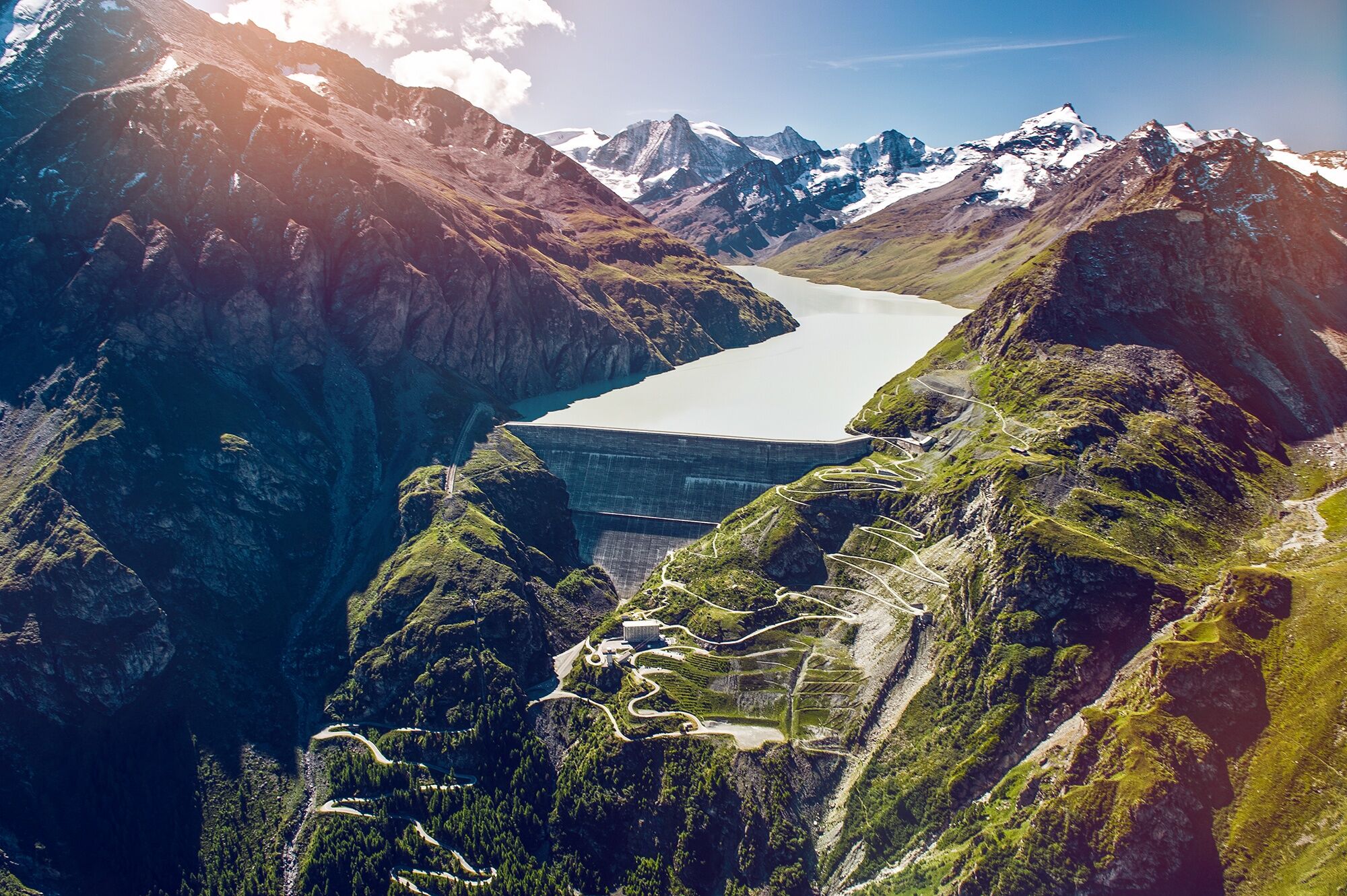
The closer you get to the destination, the more impressive the stage goal, the gigantic Grande Dixence dam, becomes. At 285m high, it is the highest gravity dam in the world and reaches a width of 200m with a weight of 15 million tons. This is more than the Great Pyramid of Giza. The reservoir – also the largest in Switzerland – stores 400 billion litres of water.
The dam is the heart of an impressive energy park. Around 100km of tunnels collect meltwater from 35 Valais glaciers and form a connected network of water reservoirs. The pioneering complex also includes 4 pumping stations and 3 power plants with a total output of 2 billion kilowatt hours of electricity per year. This is the largest power station in Switzerland in total and produces about 20% of the country's stored energy, which corresponds to the consumption of 400,000 households.
At the dam there is a free visitor centre, a restaurant and a gondola lift to the crown of the dam. Daily guided tours inside the dam are organised in summer.
Highlights of the hike:
Panoramic hike with spectacular views. Gouilles d’Essertze, idyllic ponds in the middle of a raised bog in an alpine environment. Grande Dixence, the highest gravity dam in the world with the largest power station in Switzerland.

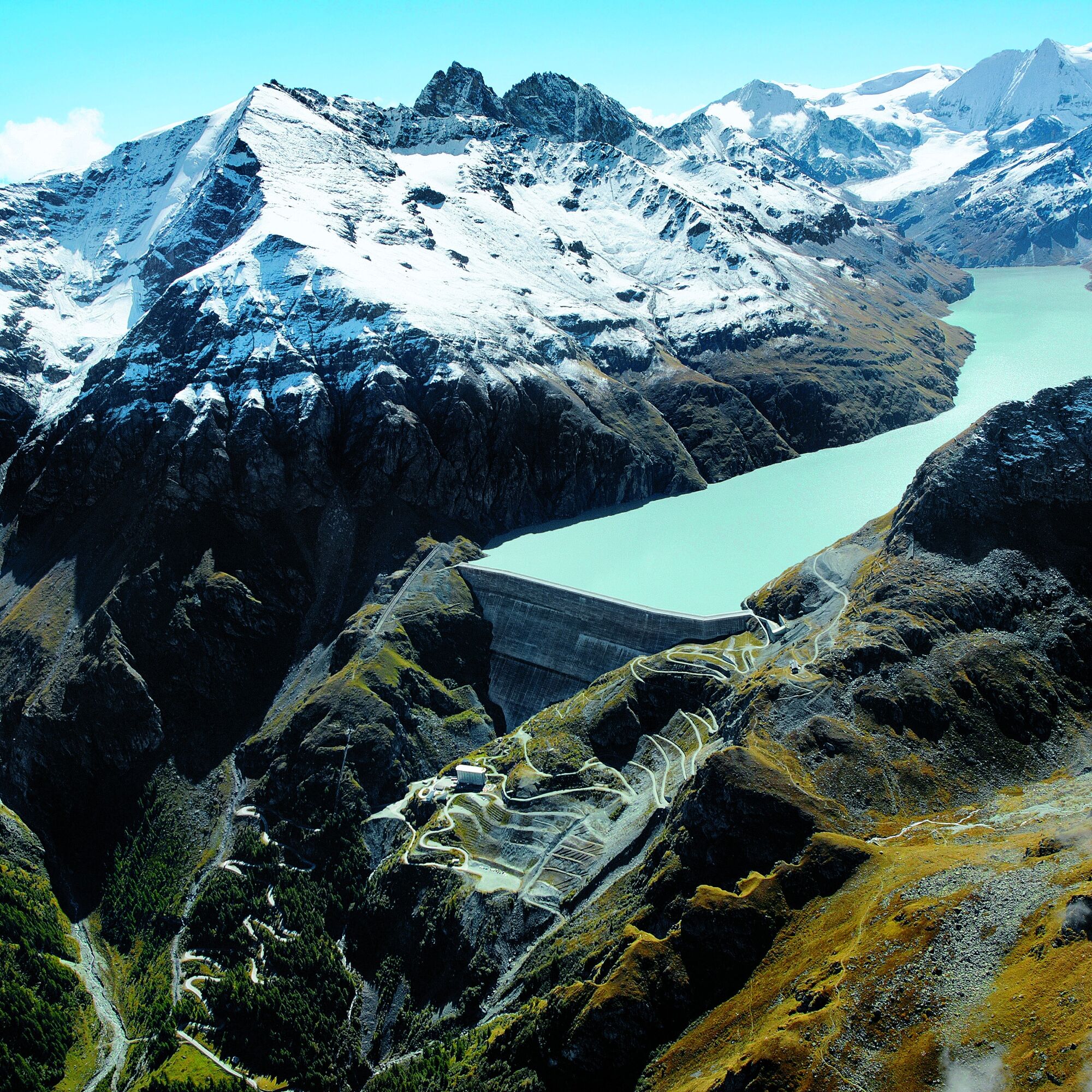
From Thyon the path leads southwards and crosses the mountain flank before it becomes steeper towards the Gouilles d'Essertze. You walk between the ponds through the raised bog before descending to the Cabane d'Essertze. This is an ideal spot for a panoramic break. From here the path leads southwards up into the Val d'Hérémence, nestled between the valley floor and the 3000m high peaks on the right-hand side. The hike ends at the dam of the Grande Dixence.
The hike can also start in Les Collons. The hamlet is about 330 metres below Thyon – allow an additional half hour for this ascent.
At the Grande Dixence, there is a hotel with a restaurant at the foot of the dam, a visitor centre, and a bus stop. From here you can take a cable car to the top of the dam. Walking up takes an additional 45 minutes.
As an alternative overnight option, hikers on the multi-day Tour du Val d'Hérens can stay at the Cabane de Prafleuri. This is about 1 hour 30 minutes' walk from the dam crown.
We recommend:
Good footwear Weather-dependent clothing: always carry a waterproof vest Headwear Sunscreen Water bottle Picnic Camera Binoculars (optional) Trekking poles (optional) Printout of the hiking route (click "Print" to download)
For certain hikes:
Swimsuit
Using the hiking trails and information on this website is at your own risk. Local conditions may cause changes to the route. Valais/Wallis Promotion assumes no responsibility for the accuracy and completeness of the information on this website. Assess your own skills and fitness level carefully. Following various routes is always at your own risk.
For all hikes:
Carry a map. Download the complete route description with a large-scale map by clicking "Print" at the top right of the page. Use only marked hiking paths and observe all signposts and instructions – for your own safety, the protection of grazing animals, and out of respect for wildlife. Close gates after passing through them. Be considerate towards other trail users, plants and animals.
For mountain hikes:
Carry additional sun protection. UV rays can be very strong at high altitudes, even in cloudy weather. Plan your hike carefully: take into account the required fitness level of all participants, weather forecasts and seasonal conditions. Weather conditions can change very quickly and without warning in the mountains. Appropriate clothing and sufficient supplies (food and drink) are very important. In unstable weather, it is better to turn back early.
For high alpine hikes:
Inform your family about your hiking route. If possible, avoid going alone. Do not venture on glaciers without a mountain guide. Observe warning signs indicating danger at riverbanks, along watercourses below dams and reservoirs: water levels can rise rapidly and without warning.
Motorway A9 to exit 27 (Sion-Est), follow the signs to Vex and then to Les Collons / Thyon.
Regular train connections from all over Switzerland to Sion, followed by a PostBus connection to Thyon 2000. There is a PostBus connection from the end of the hike at the Grande Dixence to Sion. Timetables for trains and PostBuses can be found at sbb.ch.
Parking is available at Thyon 2000. To return, change to the PostBus towards Thyon at the junction in Vex (stop Vex – bifurcation d’Hérémence). If you park your car in Sion or Vex, you do not need to return to Thyon after the hike, saving you time.
More information about the destination can be found here: Val d'Hérens
Reserve a tour inside the dam at the Grande Dixence visitor centre. Guided tours are organised daily from mid-June to September.
Obľúbené výlety v okolí
-
4,0
Belvédère via ferrata
strednáVia ferrata 1,81 km -
Arolla - Vignettes
strednáSkitour 5,04 km -
2,0
Circular hike to Cabane des Aiguilles Rouges and Lac Bleu
ťažkéTuristika 14,1 km -
From Savoleyres to the mountain lake Lac des Vaux
strednáTuristika 14,0 km -
4,0
Sentier des Chamois
ťažkéTuristika 11,6 km -
Tour du Lac de Moiry
strednáTuristika 13,4 km -
4,5
Cleuson Dam
strednáTuristika 11,5 km -
Zum Fuss des Gletschers und zurück nach Les Hauderes
strednáTuristika 12,3 km -
5,0
Sentier des bouquetins
strednáTuristika 8,73 km -
3,0
Via ferrata in the Mauvoisin Gorge
strednáVia ferrata 1,77 km
Turistika a stopovanie


Nenechajte si ujsť ponuky a inšpiráciu na ďalšiu dovolenku
Vaša e-mailová adresa bol pridaný do poštového zoznamu.