


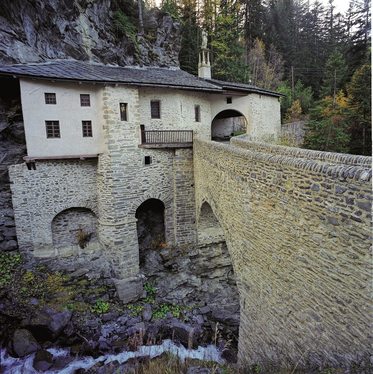
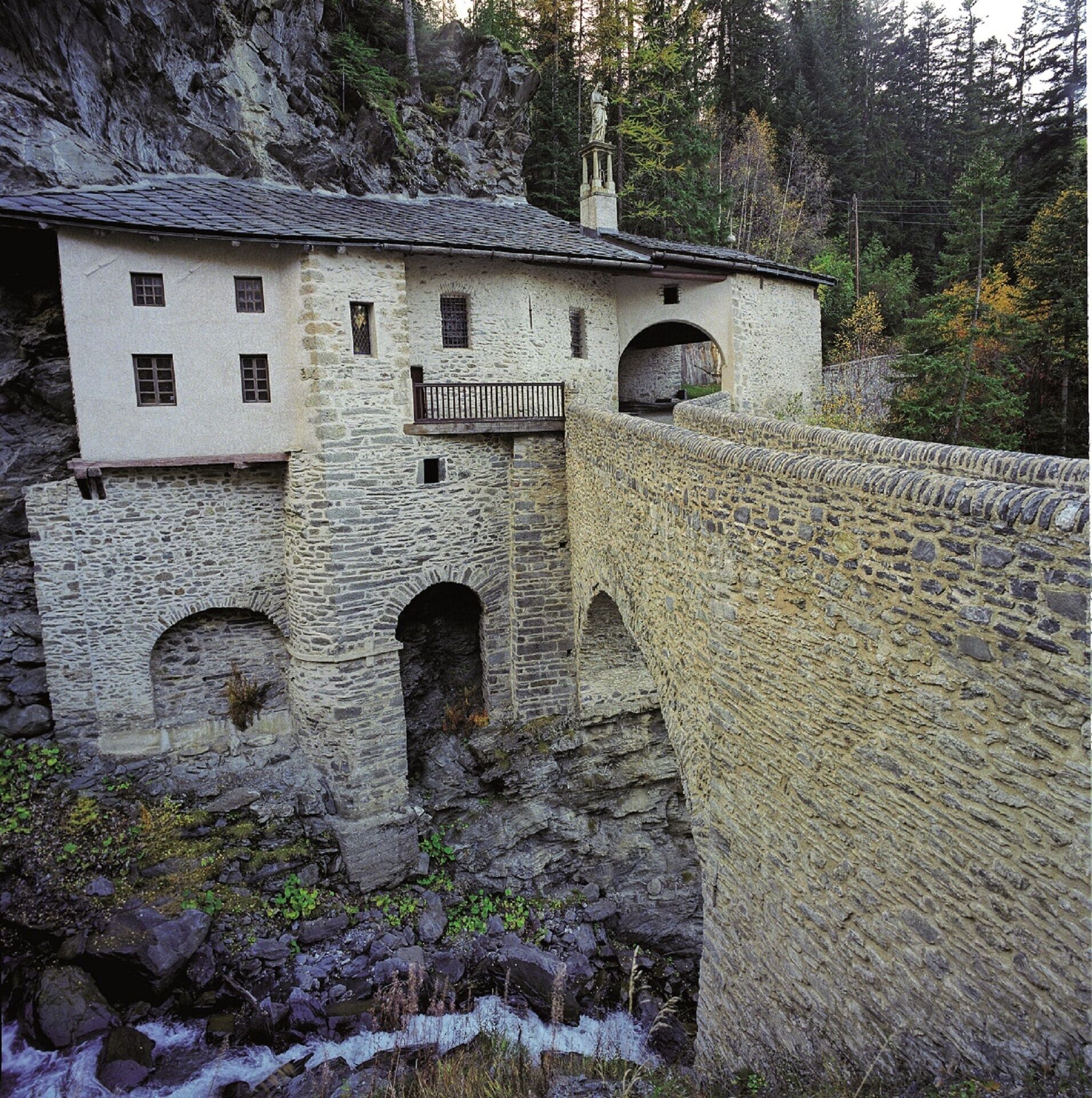
Walking tour of the Notre-Dame du Charmaix chapel


The moment you step onto the wide carriageway, the relaxing atmosphere
of this historical place washes over you. Stroll along at a light, easy pace,
enjoying the light breeze and the freshness of the trail...
The moment you step onto the wide carriageway, the relaxing atmosphere
of this historical place washes over you. Stroll along at a light, easy pace,
enjoying the light breeze and the freshness of the trail as you approach to
the building with all its secrets. You're there. Before going in to meet Our
Lady of Charmaix, why not cross the porch and go over the solid stone bridge?
Cross the Grand Vallon torrent and see the chapel and its amazing construction
from another angle. It looks like it's hanging off the cliff. Back inside, look
for Our Lady of Charmaix; admire the decorations, the paintings, and this
entirely black and white statue of a Madonna and child.
A real breath of fresh air and history. If you have a dog with you, take extra
care on the access path.
Pour vous guider sur le terrain, consultez le schéma directionnel « pas à pas » fourni en pdf.
Áno
Vêtements adaptés à la saison et aux conditions (froid, chaud, humide…)
Chaussures de randonnée adaptées au terrain (même pour les enfants !)
Bâtons de randonnée (utiles pour la stabilité et pour soulager les articulations)
Téléphone mobile et batterie de rechange
Avant de partir :
Se renseigner sur la météo générale et locale en s’assurant de l’absence de précipitations S'informer sur la marche d’approche, hauteur de l’itinéraire, temps de parcours, réchappe possible (carte IGN, GPS, topo-guide, etc…) Evaluer les risques possibles en se renseignant auprès de professionnels de montagne, refuge, gîtes S'informer un proche de votre objectif et le recontacter en cas de changement : horaires départ et retour, nombre de participants avec le numéro de téléphone de chacun, véhicule(s), parking Eviter de partir seul, utiliser un matériel conforme à la pratique de l’activité, réglé et en bon état, lampe frontale, trousse de secours complète, couverture de survie, etc…
En cas de problème
Alerter : appelez le 112 (numéro d’urgence européen)
5 points clés pour transmettre votre alerte :
Où ? commune, lieu, itinéraire, altitude Qui ? identité, numéro de téléphone Quoi ? type d’accident, nombre de victimes, gravité, cinétique de chute Quand ? heure de l’accident Météo ? vent, visibilité
Parking à proximité du point de départ
The duration of hiking trails is calculated using reference paces: 300 m/h ascent, 500 m/h descent and 4 km/h on the flat.
As hazards may occur at any time on the routes, the GPX tracks provided are not contractual. They are given for information only. Riders use them at their own risk, depending on their level of technological proficiency and their understanding of the terrain.
Obľúbené výlety v okolí
-
5,0
BARDONECCHIA Colle Sommeiller
strednáMountainbike 25,4 km -
5,0
BARDONECCHIA Decauville
svetloTuristika 7,29 km -
5,0
BARDONECCHIA Lago Verde
strednáTuristika 4,14 km -
4,5
BARDONECCHIA Sentiero Walter Bonatti - Grange della Rho
strednáTuristika 6,12 km -
5,0
BARDONECCHIA Forte Jafferau Ring
ťažkéMountainbike 36,8 km -
Refuge du Fond d'Aussois - a wild valley in the Vanoise - 2-day hike
svetloTuristika 9,24 km -
BARDONECCHIA Punta Quattro Sorelle
ťažkéTuristika 8,69 km -
BARDONECCHIA Monte Thabor
ťažkéTuristika 8,82 km -
BARDONECCHIA Punta Colomion - Passo della Mulattiera - Pian del Colle Ring
ťažkéMountainbike 25,1 km -
BARDONECCHIA Colle della Rho - Col de la Replanette - Colle di Valle Stretta Ring
ťažkéMountainbike 32,8 km
Turistika a stopovanie


Nenechajte si ujsť ponuky a inšpiráciu na ďalšiu dovolenku
Vaša e-mailová adresa bol pridaný do poštového zoznamu.