


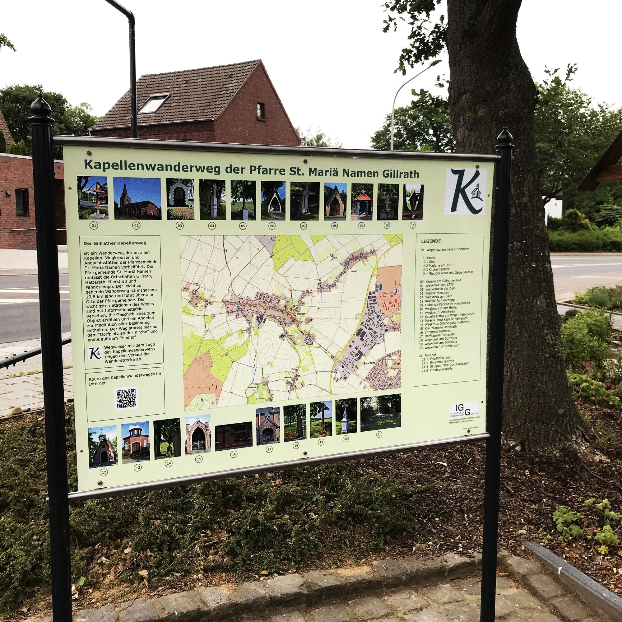
Gillrather chapel route


The easy-to-walk chapel route leads through the villages belonging to the St. Mariä Namen parish: Gillrath, Hatterath, Nierstraße and Panneschopp. Already at the starting point of the route at the newly...
The easy-to-walk chapel route leads through the villages belonging to the St. Mariä Namen parish: Gillrath, Hatterath, Nierstraße and Panneschopp. Already at the starting point of the route at the newly designed village square in Geilenkirchen-Gillrath, the impressive three-aisled church, which gave the parish its name, impresses. A large overview board whets your appetite for 21 stations to discover along the route. You follow the chapel route logo over paved country paths, through forest and meadows. At the stations, information boards provide historical background about the respective object, an offer for meditation or reflection and invite contemplation or prayer.
The route can also be wonderfully split into two almost equal stages (stations 1-11 and 12-21). Between stations 11 and 12, at the "Gillrather Bruch" rest area with a weather shelter and another overview board, there is an opportunity for a small break.
The chapel path is based on the initiative of the interest groups Gillrath and Hatterath as well as the parish council St. Mariä Namen.

The Gillrather chapel route begins at the information board at the new village square, located by the church tower of the Gillrather parish church "St. Mariä Namen".
Right on the new village square stands the 1st wayside cross and then continue along the signposts down the street "Pfarrer-Lowis-Straße" to the entrance of the Gillrather parish church, the station 2 of the route. It is open daily from 10:00 a.m. to 4:00 p.m. and can be visited (altar, church windows, Madonna from 1510).
At the end of "Pfarrer-Lowis-Straße" turn right into "Kreisbahnstraße". Following the street (from "Kreisbahnstraße" after the left curve it becomes "Bergstraße") we reach the elementary school and turn right into the paved country path, which leads us after about 100 m to the "chapel at Gillrather Hof". From there we return the same way back to "Bergstraße" and then turn right. After about 200 m (on the hilltop) we turn left into a country path, and after another 200 m turn left again up the steep hill into "Kolpingweg", which we follow until the main street and then turn right.
After about 250 m we pass station 3 (wayside cross from 1778) and then turn right onto the country path after another 50 m, which leads directly to a T-junction where we turn left. We then follow this country path to the embankment of the bypass road, where we turn right and then follow the path at the foot of the embankment until the next turn. Here we continue right towards the village "Nierstraße".
Halfway through we pass station 5 (wayside cross "In der Dell"). Upon reaching the main street of Nierstraße, we turn left and continue to station 6, the "Nierstraße chapel". Opposite the chapel, the path continues into "Panneschopper Weg", and after about 50 m turn left into the country path.
After about 200 m we reach on the right side the wayside cross "Am Bach" (station 7). From here the path goes right uphill through the meadow to "Bocket" street, where we turn right and reach after 300 m the Pannenschopp chapel" (station 8).
Further we follow the street towards Panneschopp until it goes down right at house number 70. At the crossing country path we turn right, follow it to the next paved path and turn left towards the forest. This path leads us to the Hubertus chapel (station 9), which is located right at the forest edge.
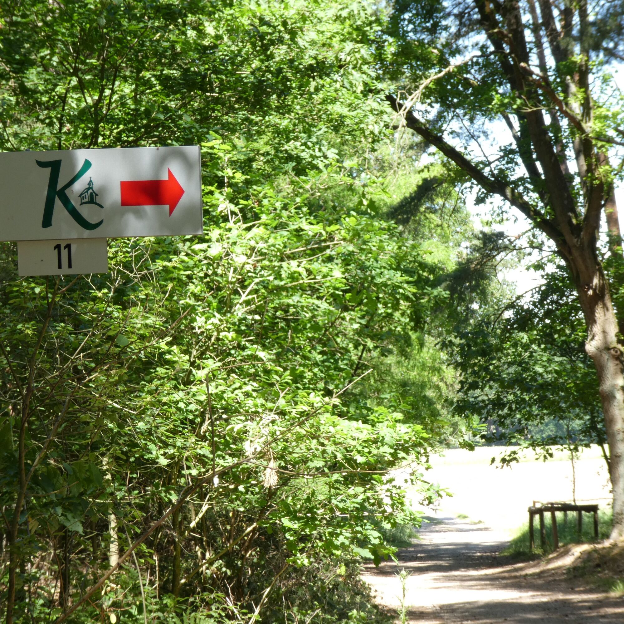
We continue along the forest path, passing station 10 (wayside cross "In der Heide") and before the end of the forest turn right. This forest path later becomes "Alleebusch" street and we follow it to a T-junction where we keep left (Von-Bronsfeld-Straße) and after 100 m reach the wayside cross "Schleifweg" (station 11).
Anyone who wants can interrupt the hike at the fork ("Schleifweg") after about 6.4 km. (Route: "Schleifweg", right towards "An der Burg", a bit along the Rodebach, changing into "Kreisbahnstraße", to the junction "Pfarrer-Lowis-Straße", and back to the starting point. The last approx. 300 m are the same as at the start of the route.)
Otherwise, we keep left at the fork and follow "Von-Bronsfeld-Straße" to the next T-junction ("An der Burg") and turn left here. Following the street around the car dealership on the right, we reach the street junction "Karl-Arnold-Straße", which we cross straight into "Hahnweg".
After a few hundred meters, we cross the tracks of the historic Selfkant railway and are at the rest area "Gillrather Bruch". Here there is another large information board about the chapel route and hikers find some resting opportunities including a weather shelter. We then follow the country path until we reach the chapel "Maria am Wege" (station 12).
After crossing "Birgdener Straße" we enter directly into a forest path, follow it to the next T-junction and turn right here. At the next T-junction turn left and then turn right at the forest edge along the country path. We follow this path for quite some time until we reach the Peter and Paul chapel (station 13) and then turn left onto the country path.
The country path runs quite a long time past the village Hatterath and at the end of the last buildings we turn right and reach the junction with "Professor-Mendel-Straße". Opposite the junction is station 14 ("wayside cross at the entrance to Hatterath"). We walk the street towards the village center until the next turn left into "Hattostraße" and head directly towards the Kreuzkapelle Hatterath (station 15).
From here we keep right and shortly after turn right into a path that leads us back onto "Professor-Mendel-Straße". Here we turn left towards the village center and on the street you pass station 16 ("Hatterath memorial"), station 17 ("Hatterath village chapel"), station 18 (wayside cross "At the village square") and station 19 (wayside cross "At the sports field").
At the height of "Salzweg" street, we turn left onto the paved country path, which leads us to station 20 ("environmental cross"). Here turn right to the street junction "Hatterather Weg". Opposite the junction is the cemetery. We use the southern entrance opposite the church by walking down "Hatterather Weg" street left towards the church, following the road around the bend until just before the T-junction with "Birgdener Straße" and then use the entrance gate to the cemetery (station 21) on the right side of the street. After about 30 m, there is a staircase up leading to this last station with the memorial, sculpture and cemetery chapel. The cemetery cross is located a little behind the cemetery chapel.
From the cemetery, you reach your starting point at the church again after a short distance.
Áno
Áno
With weather-appropriate clothing, enough water and some provisions, you are well equipped for the route.
Please pay attention to the corresponding signs in protected areas and be considerate of others.
By bicycle
Whether you come from Germany or the Netherlands, the cycling network in the Heinsberg region is seamlessly connected at its junctions to all neighboring regional cycling networks, so you can easily "ride in" from all directions. Long-distance bike routes allowing access to the region include the RurUfer cycle path, the Lower Rhine route and the Green route. When arriving by car/train/bus and bike, you can find a comfortable start to the route from every station or tourist destination.
By car
The Heinsberg region can be reached via the federal motorways A 52 (to the north), A 46 (to the east) and A 44 (to the south) as well as the Dutch A 2 (to the west). The cities of Aachen, Cologne, Düsseldorf, Duisburg and Mönchengladbach as well as Maastricht and Eindhoven in the Netherlands are within 60 kilometers.
The major federal roads running north-south are B 221 and B 57, with B 56 and B 56n running east-west. The B 56n completes the link between the A 46 and the Dutch A 2. For regional traffic, a dense network of state, district and municipal roads is available. Pay attention to the local tourist signage, which will surely lead you to your destinations.
By plane
From the internationally important airports of Düsseldorf International and Cologne-Bonn Airport, the Heinsberg region can be reached by car in about 45 or 60 minutes respectively. The Airport Weeze at the northern Lower Rhine and the airports Eindhoven Airport and Aachen-Maastricht Airport in the Netherlands are also about an hour away by car.
By train
The Heinsberg region is connected to the German railway network via three train lines.
The train line Aachen – (Heinsberg) – Düsseldorf allows travel via the stations Übach-Palenberg, Geilenkirchen, Lindern, Brachelen, Baal and Erkelenz. From Lindern, it goes to Heinsberg (HS) via stations HS-Randerath, HS-Horst, HS-Porselen, HS-Dremmen, HS-Oberbruch, HS-Kreishaus.
The greater Wegberg area is accessible via the Dalheim – Rheydt/Mönchengladbach line (stations: Dalheim, Arsbeck, Wegberg).
Via the Aachen – Eindhoven line, there is also a connection to the Dutch stations Roermond and Sittard. www.bahn.de
By bus
The regional bus network in the Heinsberg region is operated by WestVerkehr GmbH and connected to the Aachen Transport Association (AVV). AVV tariffs apply. More information and timetable information: www.avv.de. Additionally, the so-called MultiBus is available region-wide. It is an on-demand service by WestVerkehr GmbH. Passengers simply call about 60 minutes before planned departure and then receive information when the MultiBus will pick them up at the next MultiBus stop (Tel.: +49 2431 886688). More information: www.west-verkehr.de
Train & bike
Generally, traveling by train with a bicycle is easily possible. The Deutsche Bahn timetable indicates which trains have bike carriages. Because bike spaces are limited, groups should register with the railway in advance. www.bahn.de
Bus & bike
On weekdays from 7:00 p.m., Saturdays from 3:00 p.m. and all day on Sundays and holidays, bicycles can be taken on Heinsberg region buses. A maximum of 2 bicycles per vehicle are allowed.
By bus and bike through the Heinsberg region – the „Fahrradbus Region Heinsberg“
During the season, the "Fahrradbus Region Heinsberg" takes excursionists with and without bicycles to their respective route starting points on all Saturdays and Sundays/holidays and picks them up afterwards. While comfortably seated in a west-MultiBus, your bike is safely transported in the attached bike trailer. The buses have seating for 7 people. The attached bicycle trailer can transport up to 16 bicycles. By the way: if you travel by train, the bike bus also picks you up directly at the stations in the Heinsberg region.
The bike buses run between 9:00 a.m. and 8:00 p.m. and cover numerous stops. They do not follow a fixed route nor fixed timetable. Instead, you can pre-order the bike bus at the MultiBus center at the desired time at the desired bus stop. Book your desired appointment and a place in the westFahrradbus via the MultiBus hotline 02431/886688 (at least one day before the route).
Whether a bike route or hiking trip, with the bike bus you can easily access the most beautiful routes in the Heinsberg region and enjoy a relaxed start or finish to your trip. A tariff overview and special offers for groups can be found at www.west-verkehr.de
The Selfkantbahn,
the only and last narrow-gauge steam railway in North Rhine-Westphalia, is not only a popular excursion destination but is also still available today as a means of transport: Passengers and their bicycles are gladly taken along. It usually runs from Easter to the end of September on Sundays and holidays between the stations Gangelt-Schierwaldenrath and Geilenkirchen-Gillrath. www.selfkantbahn.de
Free parking is available at the church (entrance from Karl-Arnold-Straße by the church tower) and alongside and behind the fire station on Kreisbahnstraße in 52552 Geilenkirchen-Gillrath.
Information on the chapel route:
Interessengemeinschaft Gillrath e.V.
​info@ig-gillrath.de
https://www.ig-gillrath.de/kapellenweg
Information about the Heinsberg region:
WFG for the district of Heinsberg Ltd.
Heinsberg region
Tel.: +49 2452 131415 Fax: 131419
info@heinsberger-land.de
www.heinsberger-land.de
Visit the cribs lovingly and individually designed by children at the chapels during Advent (including small surprises...).
Obľúbené výlety v okolí
-
The RurUfer cycle path in Heinsberger Land
svetloCyklistika 27,9 km -
Bike by numbers into the Wurm and Rodebach valley (RW 114)
Cyklistika 49,1 km -
5,0
Route tip 106 - 2nd Raderlebnistag Niederrhein 2025
strednáCyklistika 45,8 km -
4,0
Route tip 103 - 2nd Cycling Experience Day Lower Rhine 2025
strednáCyklistika 40,0 km -
Right and left of the Rur in Heinsberg Land - change is the only constant
strednáCyklistika 49,2 km -
Route tip 108 (shortcut GA-SK) - 2nd cycling experience day Lower Rhine 2025
strednáCyklistika 34,5 km -
West-Bike-Route
strednáCyklistika 197,3 km -
Teverener Heide - Heiderundweg
svetloTuristika 6,21 km -
Selfkant circular route: Deep in the west
svetloCyklistika 29,4 km -
Route tip 113 2nd Raderlebnistag Niederrhein 2025
strednáCyklistika 45,1 km
Turistika a stopovanie


Nenechajte si ujsť ponuky a inšpiráciu na ďalšiu dovolenku
Vaša e-mailová adresa bol pridaný do poštového zoznamu.