M12 Mountain Bike Tour B2 from Monsols to Ouroux
ťažké
Navigácia na stránke
Navigácia na stránke
Získajte túto prehliadku v mobilnom telefóne
M12 Mountain Bike Tour B2 from Monsols to Ouroux
ťažké
Mountainbike
22,53
km
Naskenujte kód QR a spustite navigáciu v aplikácii bergfex

Turistika a stopovanie


M12 Mountain Bike Tour B2 from Monsols to Ouroux
ťažké
Vzdialenosť
22,53
km
Trvanie
02:15
h
Ascent
718
hm
Hladina mora
399 -
729
m
Stiahnutie skladby
M12 Mountain Bike Tour B2 from Monsols to Ouroux
ťažké
Mountainbike
22,53
km
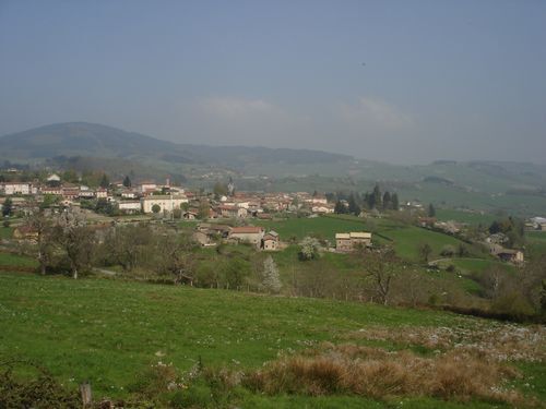
Discover the valleys of the two Grosnes on this sporty tour through the western valley which has its source in Monsols and the eastern valley which passes through Ouroux. Discover the valleys of the two...
Opis
Discover the valleys of the two Grosnes on this sporty tour through the western valley which has its source in Monsols and the eastern valley which passes through Ouroux. Discover the valleys of the two Grosnes on this sporty tour through the western valley which has its source in Monsols and the eastern valley which passes through Ouroux.
Trasa
Crête Rouge
(748 m)
Summit
1,4 km
Église Saint-Antoine
(446 m)
Miesto uctievania
7,4 km
Les Friats
(481 m)
Zúčtovanie
7,9 km
Le Carruge
(541 m)
Zúčtovanie
8,4 km
Église Sainte-Marie-Magdeleine
(417 m)
Miesto uctievania
12,6 km
Monsols
(536 m)
Dedina
20,0 km
Les Charbonniers
(566 m)
Zúčtovanie
20,5 km
Trasa
M12 Mountain Bike Tour B2 from Monsols to Ouroux
ťažké
Mountainbike
22,53
km
Crête Rouge
(748 m)
Summit
1,4 km
La Croix du Pendu
(729 m)
Koridor/terén
1,4 km
Carrefour du Trou du Loup
(566 m)
Koridor/terén
5,5 km
Gros Bois
(524 m)
Zúčtovanie
5,9 km
Ouroux
(447 m)
Dedina
7,4 km
Église Saint-Antoine
(446 m)
Miesto uctievania
7,4 km
Les Friats
(481 m)
Zúčtovanie
7,9 km
Source du Carruge
(545 m)
Zdroj
8,3 km
Le Carruge
(541 m)
Zúčtovanie
8,4 km
Nelbert
(604 m)
Koridor/terén
8,8 km
Saint-Mamert
(401 m)
Dedina
12,5 km
Église Sainte-Marie-Magdeleine
(417 m)
Miesto uctievania
12,6 km
Le Saint-Rigaud
(537 m)
Reštaurácia
20,0 km
Monsols
(536 m)
Dedina
20,0 km
Les Charbonniers
(566 m)
Zúčtovanie
20,5 km
Chonay
(577 m)
Susedstvo
21,0 km
Autor
Poskytuje Rhône Tourisme
Prehliadku M12 Mountain Bike Tour B2 from Monsols to Ouroux zabezpečuje outdooractive.com.

Ďalšie informácie a tipy
Ďalšie informácie
APIDAE tourism data updated on 15/02/2023 by "Destination Beaujolais".
Spotted an error? Write to the owner with the following information:
File name: Circuit VTT M12 de Monsols à Ouroux | Record identifier: 162060 | URL (link) for this Outdooractive page.
Spotted an error? Write to the owner with the following information:
File name: Circuit VTT M12 de Monsols à Ouroux | Record identifier: 162060 | URL (link) for this Outdooractive page.
Zatiaľ žiadne recenzie
Obľúbené výlety v okolí
-
5,0
The secrets of the Roche de Solutré
strednáTuristika 3,97 km -
Escapade nature - De Mâcon Loché à La Grange du Bois
strednáTuristika 13,8 km -
Escapade Nature au cœur du Grand Site de France Solutré Pouilly Vergisson
strednáTuristika 29,9 km -
Les sentiers belles vues - Saint-Amour-Bellevue
strednáTuristika 12,3 km -
5,0
B3 Mountain Bike Tour from Beaujeu to St Didier/Beaujeu
ťažkéMountainbike 22,6 km -
CycloRoute71 - Etape 12 de Cluny à Mâcon
strednáCyklistika 66,2 km -
B5 Mountain Bike Tour from Fleurie to Chénas
ťažkéMountainbike 20,7 km -
Circuit des croix
strednáJazda na koni 15,8 km -
The Beaujolais vineyard - Beaujolais - Chiroubles
svetloTuristika 12,5 km -
B9 Mountain Bike Tour Marchampt
ťažkéMountainbike 19,8 km
Turistika a stopovanie

Viac ako 550.000 návrhov výletov, podrobné mapy a intuitívny plánovač trás robia z aplikácie povinnú výbavu pre všetkých nadšencov prírody.

Nenechajte si ujsť ponuky a inšpiráciu na ďalšiu dovolenku
Prihlásiť sa k odberu noviniek
Chyba
Vyskytla sa chyba. Prosím, skúste to znova.
Ďakujeme za vašu registráciu
Vaša e-mailová adresa bol pridaný do poštového zoznamu.
Zájazdy po celej Európe
Rakúsko
Švajčiarsko
Nemecko
Taliansko
Slovinsko
Francúzsko
Holandsko
Belgicko
Poľsko
Lichtenštajnsko
Česko
Slovensko
španielsko
Hrvaška
Bosna a Hercegovina
Luxembursko
Andorra
Portugalsko
Island
Spojené kráľovstvo
Írsko
Grécko
Albánsko
Severné Macedónsko
Malta
Nórsko
Čierna Hora
Moldavsko
Kosovo
Maďarsko
San Maríno
Rumunsko
Estónsko
Lotyšsko
Bielorusko
Cyprus
Litva
Srbsko
Bulharsko
Monako
Dánsko
Švédsko
Fínsko