


Cycle by numbers through forest and fields to our Dutch neighbors (RW 102)
Úroveň náročnosti: 1
The starting point of this route is the free parking lot at St. Maria Church in Heinsberg-Unterbruch on Wassenberger Straße. From there, you take the bike path along the B 221 turning left towards Heinsberg...
The starting point of this route is the free parking lot at St. Maria Church in Heinsberg-Unterbruch on Wassenberger Straße. From there, you take the bike path along the B 221 turning left towards Heinsberg heading to junction no. 11 (â11). Then continue right towards â13 and â14 to Karken. From â14, continue about 1.5 km to the German-Dutch “border”. Behind the “border crossing”, choose the bike path left at â58 (Dutch junction system) towards Posterholt to â59, â69 and onwards to â68.
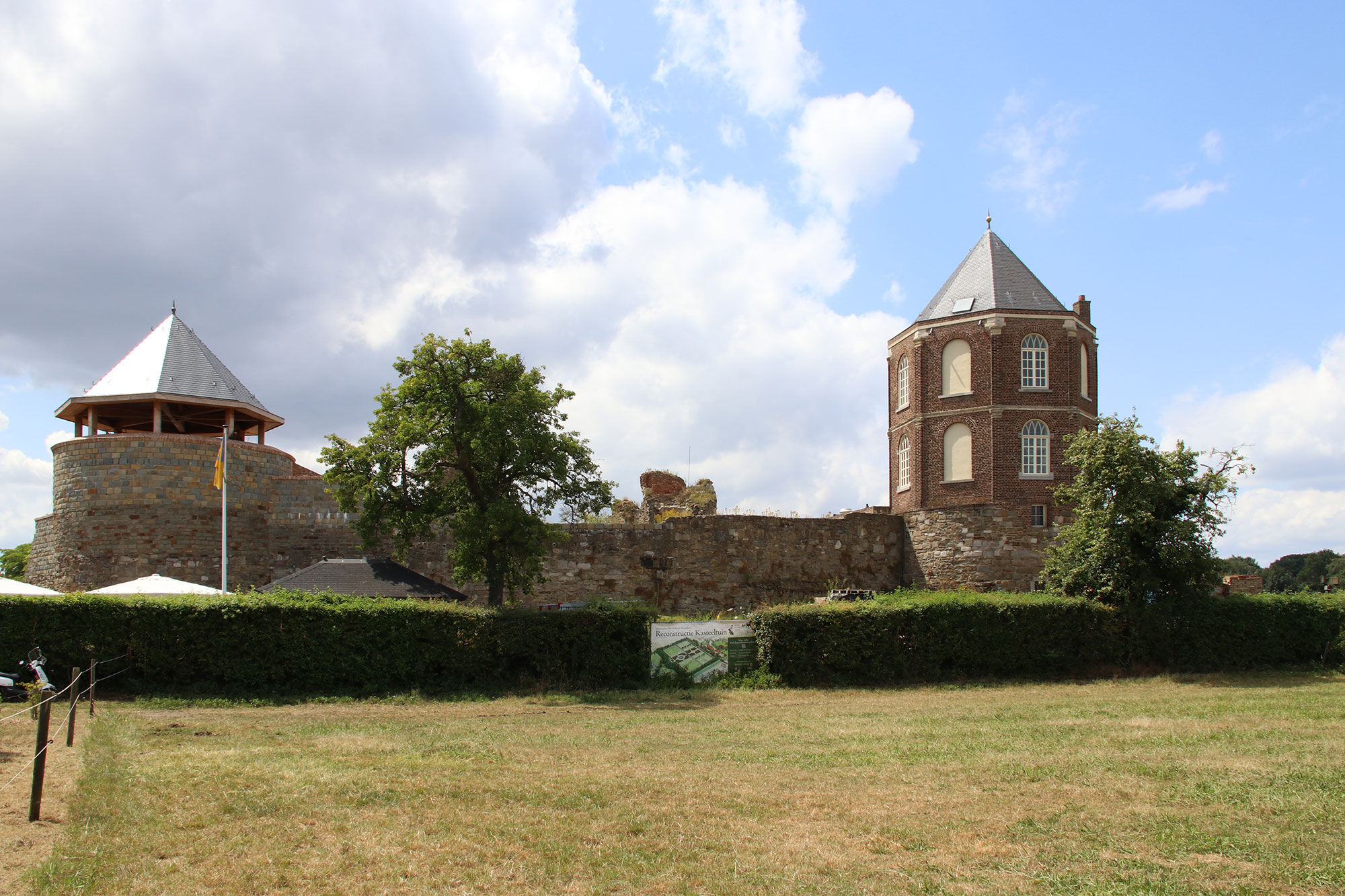
This route leads through the so-called “Elsbroek” (Eschen marsh). The “Vlootbach”, formerly a tributary of the Rur river, accompanies you on the way. From the former “Annendael” castle you can still see the remains of the gate and the former farmhouse. From â68 towards â03 you first pass through a forest, then through open farmland with slightly marshy sandy soil (about 2 km of unpaved path). The “Vlootbeek” forms here the border to “het Sweeltje,” a forest developed on ice-age formed drifting sand dunes. At â03 you can see remains of Montfort Castle on the south side of Montfort town. It was the administrative center of the region in the Middle Ages.
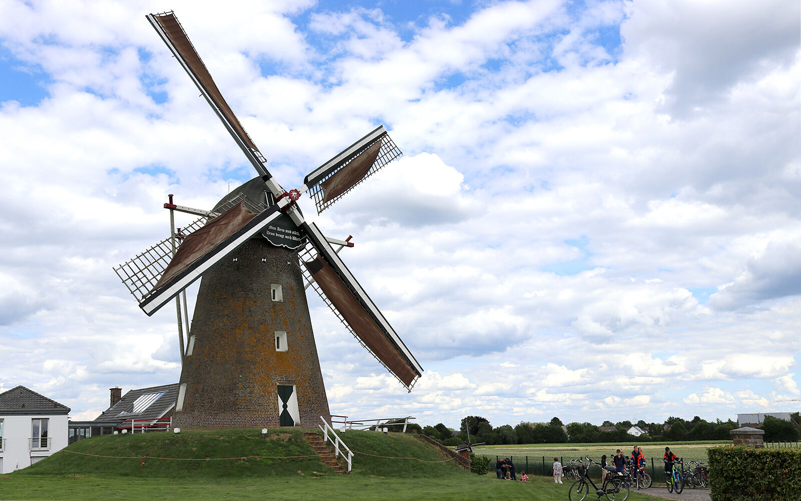
Continue towards â02 and then to â01 (about 2 km of unpaved path). From this point, first proceed towards â68 and then on the German side to â35 and further to â39. On the way to â12 you can make a detour of about 500 m to the Haaren windmill. Since 1921, this mill has been owned by the Dutch family Verbeek. Maybe you are lucky and the miller is at work, i.e. the mill operates in sufficient wind. An always exciting endeavor. The flour ground in this mill can be bought pure, among other things, at Johannesstr. 28 near the mill.
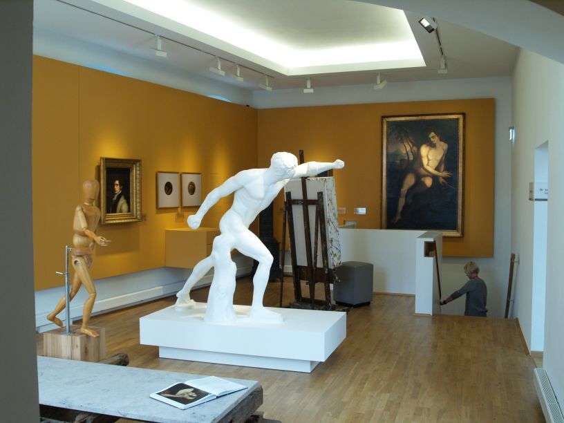
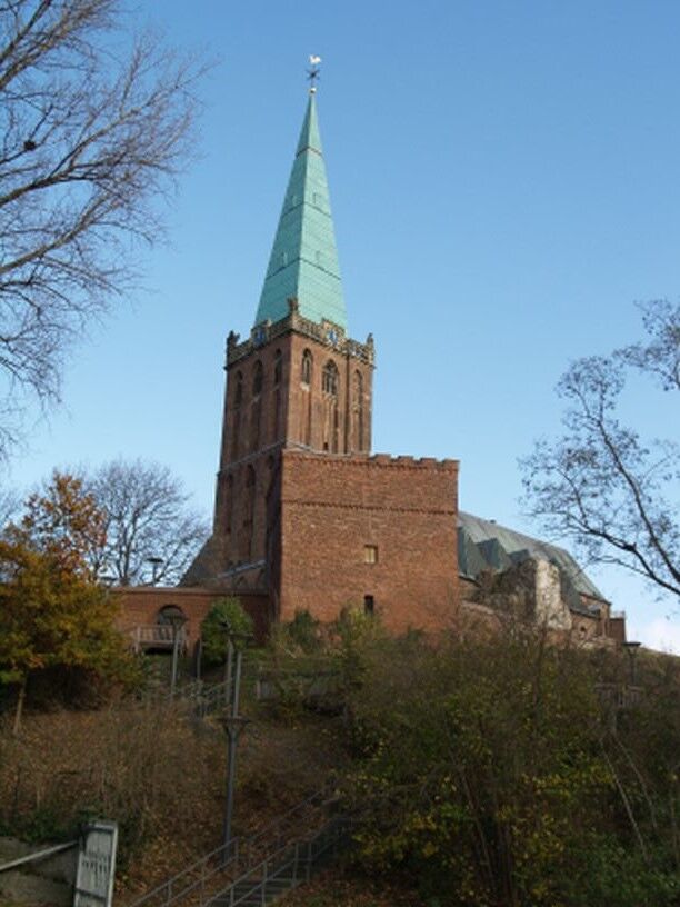
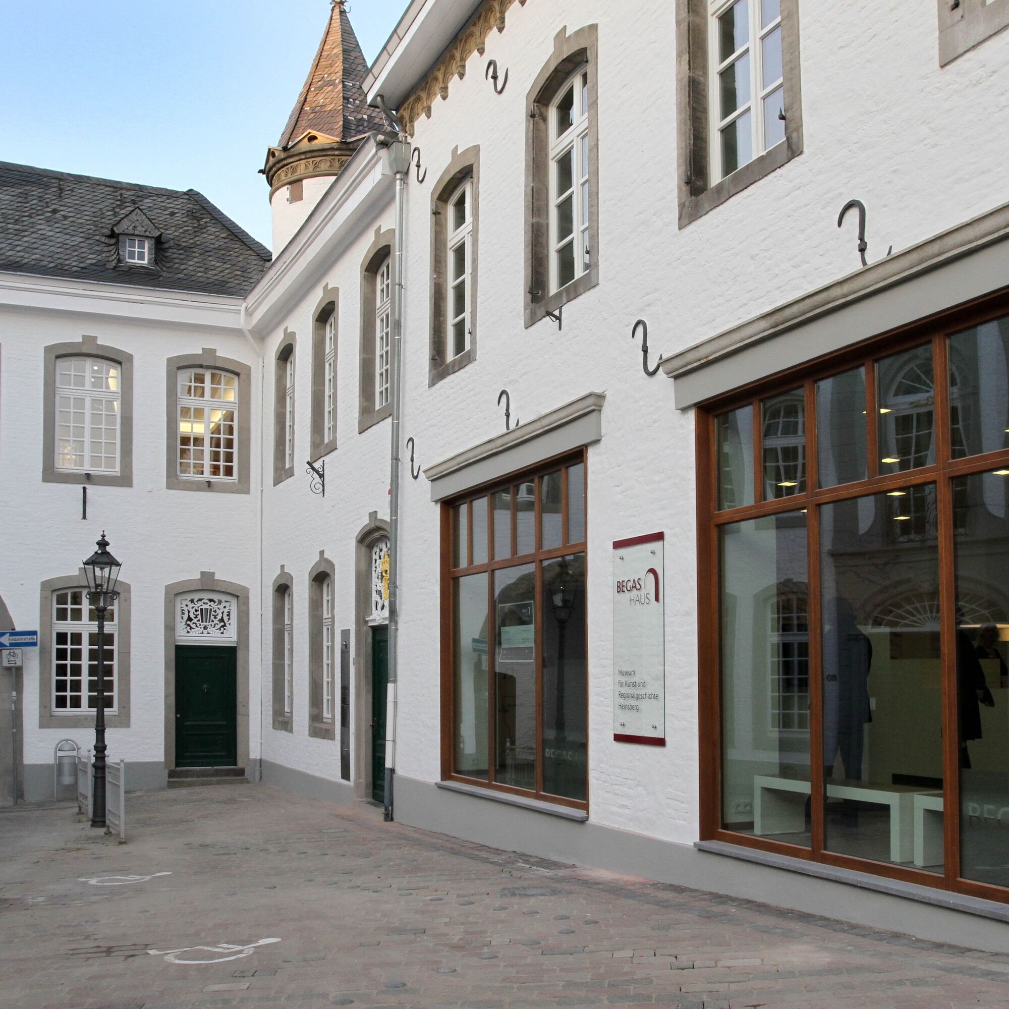
Back on the marked path, proceed via â12 and â20 into the district town Heinsberg. There, admire the impressive Provost Church “St. Gangolfus” - called “Selfkantdom” in the region - on the newly designed castle hill with castle ruins and remains of the city fortifications. During a guided tour, you will also learn interesting facts about the crypt and the high grave of the Lords of Heinsberg. The former district museum, located in the white arched gatehouse, has been completely redesigned and rebuilt. It now shines under the name - the “BEGAS HAUS - Museum for Art and Regional History” - offering interesting insights into the Begas artist family and regional historical contexts with an innovative presentation concept.
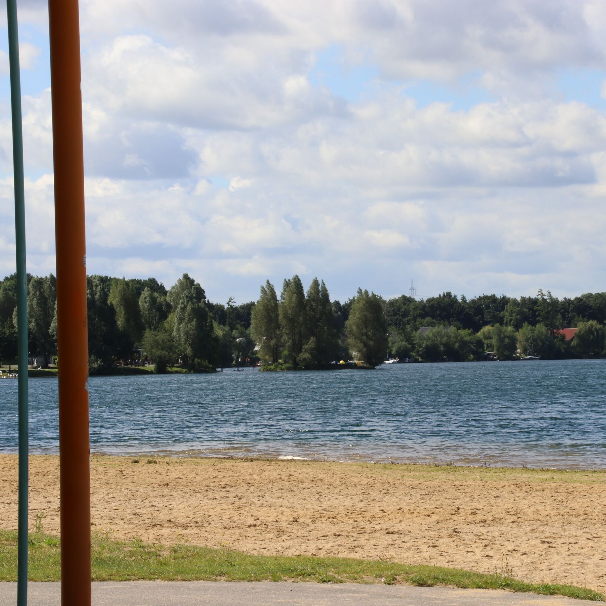
Perhaps linger at the marketplace and watch the lively hustle and bustle of the people of Heinsberg and their visitors. Or you can cycle to the nearby “Lago Laprello,” a wonderful local recreation area on the edge of the city center. Here, you can enjoy the peace on the lake while pedal boating. Then cycle back towards â11 and further towards â22. On this route, you return to the starting point of the tour at the parking lot at the church. To conclude this day, you might visit an exhibition (please check the event calendar) at the rooms of the Kunstverein Region Heinsberg, about 1 km from the parking lot. Just follow the signposts!
From the parking lot, cycle on the bike path towards the B221 and turn left at the junction, heading towards junction â11.
From there, follow the junctions â13 â14 â58 â59 â69 â68 â03 â07 â02 â01 â68 â35 â39 â12 â20 â11 and then towards junction â22, where you will return to the St. Maria parking lot.
With weather-appropriate clothing, enough water and some provisions, you are well equipped for the route.
Please stay on the paths and be considerate of others.
For individual planning of your arrival by car, use our route planner and enter "Wassenberger Str. 79, Heinsberg" as the destination.
Your personal connection information with fare details for travel by public transport can be found at: www.avv.de
Free parking is available at the starting point of the route at the St. Maria Church in Heinsberg-Unterbruch.
1
WFG for the district of Heinsberg mbH
Heinsberger Land
Tel.: +49 2452 131415 Fax: 131419
E-mail: info@heinsberger-land.de
Internet: www.heinsberger-land
Highlights:
- Haarener Windmill, Am Elschen, D-52525 Waldfeucht-Haaren: Visits/tours by arrangement with the Verbeek family possible for groups of 10 or more, Tel. +49 173-2843281; country shop: Johannesstr. 28, opening hours: Mon - Fri 8:30 AM - 12 PM and 1:45 PM - 6 PM, Sat 8 AM - 1 PM, Mon closed, www.muehlenverein-selfkant.de
- BEGAS HAUS Museum, Hochstr. 21, D-52525 Heinsberg: Tue - Sat 2 PM - 5 PM, Sun 11 AM - 5 PM (special hours on holidays), Mon closed, Tel. +49 (0)24 52 - 97 76 90, www.begas-haus.de
- Provost Church St. Gangolfus (Selfkantdom): Open weekdays except Wednesdays 10 AM - 5 PM, Sat 10 AM - 6 PM, Sun 10 AM - 5 PM; tours by appointment for groups of 4 or more (also with tower climb), Parish office Tel. +49 (0)24 52 - 2 20 34
- Kunstverein Region Heinsberg e.V., Horster Hof 1, D-52525 Heinsberg-Unterbruch, Tel. +49 (0)24 52 - 6 55 98, opening hours: Fri 3 PM - 6 PM and Sun 11 AM - 5 PM during exhibitions; www.kunstverein-heinsberg.de
Tours: The guides of the association “Westblicke e.V.” offer tours on many topics in the Heinsberger Land (www.westblicke.de).
Obľúbené výlety v okolí
-
4,5
Traumweg Wildes Schaagbachtal
svetloTuristika 8,92 km -
Meinweg
svetloTuristika 16,2 km -
Premium-Wanderweg Molenplas - Wasser.Wander.Welt.
svetloCyklistika 7,58 km -
Premium-Wanderweg Birgeler Urwald - Wasser.Wander.Welt.
strednáCyklistika 14,2 km -
5,0
Von Heinsberg Kirchhoven entlang der Wurm nach Geilenkirchen #LL2ROM V08 (Erkelenz-Aachen 2 von 4)
svetloTuristika 24,5 km -
Premium-Wanderweg Meinvennen - Wasser.Wander.Welt.
ťažkéCyklistika 17,6 km -
5,0
Von Erkelenz via Birgelner Urwald nach Heinsberg Kirchhoven #LL2ROM V07 (Erkelenz-Aachen 1 von 4)
strednáTuristika 31,2 km -
Effelder Waldsee-Pfad - Leichte.Wander.Welt.
svetloCyklistika 4,84 km -
Kleiner Grenzverkehr (Rundwanderweg Hillenkamp)
svetloCyklistika 10,4 km -
Tiefe Gräben - Weite Blicke (Rundwanderung Lüsekamp)
svetloCyklistika 7,23 km

Turistika a stopovanie


Nenechajte si ujsť ponuky a inšpiráciu na ďalšiu dovolenku
Vaša e-mailová adresa bol pridaný do poštového zoznamu.