


GR de pays « waterfalls, moors and peat bogs »
Along these 65 km you will be able to appreciate the quality of our environment, set off to discover unique natural sites and get to know the local traditions through the built heritage elements that line...
Along these 65 km you will be able to appreciate the quality of our environment, set off to discover unique natural sites and get to know the local traditions through the built heritage elements that line the route.
Starting signs are installed at the four possible starting points: Bourganeuf, Morterolles, Royère-de-Vassivière and Saint-Junien-la-Bregère.
By doing this large hiking loop, you will have the opportunity to find on your way protected sites full of mystery:
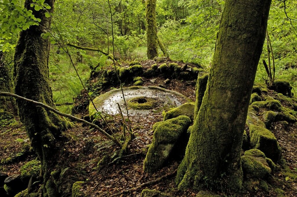
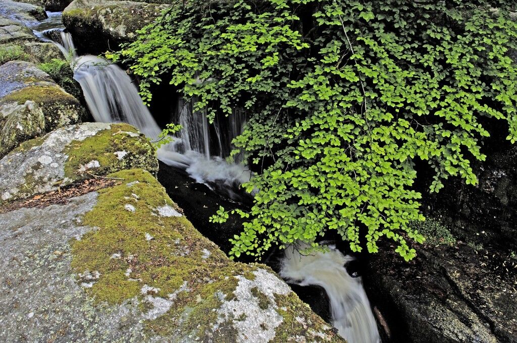
the classified site of the Gorges du Verger (Bourganeuf), the Natura 2000 site of the Bourdeau pond (Saint Pardoux Morterolles), the classified site of the stone fields and waterfalls of Augerolles (Saint Pardoux Morterolles), the classified site of the Jarrauds waterfall (Saint Martin Château), the registered site of the Mazuras rocks (Faux-Mazuras),but also hamlets characteristic of the territory: Chignat (Soubrebost), Morterolles (Saint-Pardoux Morterolles), Haute-Faye and Les Bordes (Royère de Vassivière), Grand and Petit Mazuras (Faux Mazuras), as well as elements of the small built heritage: Hydraulic complex of Haute-Faye, numerous crosses, washhouses, wells, mills (including the fully restored Augerolles mill), etc.
... and finally museums of Art and History: Electrification Museum (in Bourganeuf) and the Grande Brodée (Le Breuil – Saint Pardoux Morterolles)
This trail can be done in several stages depending on accommodation and catering locations.
Starting from Bourganeuf
Red and yellow markings
Bourganeuf – Saint Junien la Brégère = 13 km
Possible detour to the Mazuras rocksSaint Junien la Brégère – Royère de Vassivière = 21 km
Passing through Montayaud, Passing through Saint Martin Château Possible detour to the Jarrauds Waterfalls Passing through Les BordesRoyère de Vassivière – Morterolles = 18 km
Passing through Haute Faye Possible detour to the viewpoint of the Pic signal Passing through La Chaize, the village and the moor of Augerolles Possible detour by the discovery trail of the Augerolles waterfalls Passing through Freisseix Possible detour to the Natura 2000 site of the Bourdeau pond Passing through MorterollesMorterolles – Bourganeuf = 13 km
Passing through Chanteloube, Chignat, Chadoulénas, and Faux MazurasPassing through the classified site of the Gorges du Verger
Starting from Royère de Vassivière
Royère de Vassivière – Saint Junien la Brégère = 21 km
Passing through Les Bordes with a possible detour to the Jarrauds Waterfalls Passing through Saint Martin Château Passing through MontayaudSaint Junien la Brégère – Le Breuil = 24 km
Passing through Grand Mazuras with a possible detour to the Mazuras rocks Passing through Bourganeuf passing through the classified site of the Gorges du Verger Passing through Faux Mazuras, Chadoulénas, Chignat and ChanteloubeLe Breuil – Royère de Vassivière = 20 km
Passing through Morterolles Possible detour to the Natura 2000 site of the Bourdeau pond Passing through Freisseix Possible detour to the discovery trail of the Augerolles waterfalls Passing through La Chaize, the village and the moor of Augerolles Possible detour to the viewpoint of the Pic signal Passing through Haute FayeA well-maintained and well-equipped bike helps ensure your safety as well as that of other road users.
Before leaving:
Make sure the bike is in perfect mechanical condition, including tires and brakes Ensure the bike is properly adjusted to your body shape Wearing a helmet is strongly recommended Take a repair kit with you Remember that the highway code applies to cyclists at all times Never ride more than two abreast and keep in a single file when traffic conditions require it Respect other users as you would like them to respect you Choose a route suited to your physical abilities Inform those around you of your itinerary Check the weather conditions A first aid kit is not essential but can be very useful Check and keep emergency numbers handy Respect the environment by not throwing your food wrappers on the roadside If you have to return at nightfall, make sure you can see and be seenFor people who have difficulty hearing or speaking: 114 by SMS
Intercommunal Tourist Office Waters, Tours of Bourganeuf and Royère de Vassivière
Place du champ de foire - BP 42
23400 Bourganeuf
Tel. +33 50 5 55 64 12 20
Email: contact@ot-bourganeuf.com or eaux-tours@wanadoo.fr
Obľúbené výlety v okolí
-
Bike loop 50 - Saint-Dizier-Leyrenne and the Thaurion valley
strednáCestný bicykel 19,1 km -
Circuit N°63 CC : Sentier "Histoire et Patrimoine"
ťažkéJazda na koni 27,6 km -
Circuit Pédestre N°21 CC : "Sentier de découverte de la Rigole du Diable"
svetloTuristika 2,91 km -
Circuit N°63 CC : Sentier "Histoire et Patrimoine" - Variante Est
strednáJazda na koni 18,6 km -
Lake Vassivière lakeside path
svetloMountainbike 26,0 km -
GR de Pays "Cascades, landes et tourbières" GRP65
ťažkéJazda na koni 67,1 km -
Tour du lac de Vassivière, "Sentier de rives"
strednáJazda na koni 25,9 km -
The moors and peat bogs of the Mazure
svetloTematická trasa 7,41 km -
La Vélidéale in Creuse: Royère-de-Vassivière / Bujaleuf
svetloDiaľková cyklotrasa 35,0 km -
Circuit Pédestre N°56 : "Sentier de découverte des Champs de pierres et cascades d'Augerolles"
strednáTuristika 2,60 km
Turistika a stopovanie


Nenechajte si ujsť ponuky a inšpiráciu na ďalšiu dovolenku
Vaša e-mailová adresa bol pridaný do poštového zoznamu.