







Boucle de la forêt de St Crépin

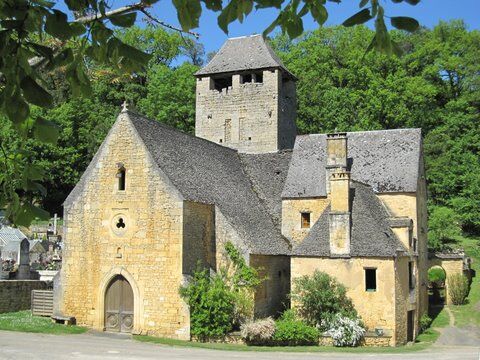
You like the beautiful stones and forests of the Pays de Fénelon? Then this hike is for you. The small patrimony is omnipresent in the village of Saint-Crépin: you will enjoy it. There are also beautiful...
You like the beautiful stones and forests of the Pays de Fénelon? Then this hike is for you. The small patrimony is omnipresent in the village of Saint-Crépin: you will enjoy it. There are also beautiful views of the landscape to admire along the way.
From the signpost at the parking lot at the bottom of the village of Saint-Crépin, go up the road towards the cemetery. At the cemetery, go up to the left and follow a sloping path that quickly rises along a dry stone wall. Continue and then go to the right.


Áno
OT du pays de Fénelon
Obľúbené výlety v okolí
-
5,0
Boucle de la Turançonnaise n°14 / La Chapelle Aubareil
strednáTuristika 9,42 km -
Boucle de Montfort
svetloTuristika 7,85 km -
Boucle La Salamandre
svetloTuristika 5,57 km -
Boucle La Combe du Loup
svetloTuristika 12,9 km -
5,0
Boucle de l'Albaroise n° 15 / La Chapelle Aubareil
strednáJazda na koni 9,86 km -
Boucle de la Fontaine des Graves
strednáTuristika 8,99 km -
Boucle Promenade de Lascaux n° 17 / Montignac
strednáTuristika 6,95 km -
Boucle de Saint Quentin
strednáTuristika 14,0 km -
5,0
Boucle des Cabanes n °9 / Sergeac
strednáJazda na koni 7,29 km -
Boucle des Gabarres
svetloTuristika 3,25 km
Turistika a stopovanie


Nenechajte si ujsť ponuky a inšpiráciu na ďalšiu dovolenku
Vaša e-mailová adresa bol pridaný do poštového zoznamu.





