
GRP Tour du Bassin d’Arcachon - De Biganos à Lège en écomobilité
Turistika
Získajte túto prehliadku v mobilnom telefóne
GRP Tour du Bassin d’Arcachon - De Biganos à Lège en écomobilité
Turistika
42,59
km
Naskenujte kód QR a spustite navigáciu v aplikácii bergfex


Turistika a stopovanie





GRP Tour du Bassin d’Arcachon - De Biganos à Lège en écomobilité
Turistika
Vzdialenosť
42,6
km
Trvanie
10:11
h
Ascent
-
hm
Hladina mora
1 -
11
m
Stiahnutie skladby
GRP Tour du Bassin d’Arcachon - De Biganos à Lège en écomobilité
Turistika
42,59
km
This section of the GRP tour du Bassin d'Arcachon runs along the northern coast of the Leyre delta, less well known than the southern coast, but wilder and more typical. Sights along the way include the...
Opis
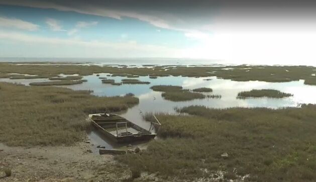
This section of the GRP tour du Bassin d'Arcachon runs along the northern coast of the Leyre delta, less well known than the southern coast, but wilder and more typical. Sights along the way include the ports of Biganos, Lanton, Andernos and Arès, with their oyster huts; the ecological reserves of the Certes estate and the salt meadows of Arès and Lège Cap Ferret; and the built heritage of the villages of Lanton and Andernos. Check the tide tables, as some passages are inaccessible at high tide. Further information on the GRP Tour du bassin d?Arcachon guidebook.
This route is proposed by the Comité Régional de Randonnée Pédestre. Departing from a train station or TER bus stop, it allows you to join a walking or hiking itinerary, and to take an ecomobility trip!
This route is proposed by the Comité Régional de Randonnée Pédestre. Departing from a train station or TER bus stop, it allows you to join a walking or hiking itinerary, and to take an ecomobility trip!
Trasa
Biganos
(12 m)
Dedina
0,4 km
Comprian
(4 m)
Zúčtovanie
5,7 km
Audenge
(5 m)
Dedina
13,0 km
Résidence La Palmeraie
(5 m)
Susedstvo
24,3 km
Le Mauret
(4 m)
Zúčtovanie
28,2 km
Église Saint-Éloi
(4 m)
Miesto uctievania
31,7 km
Arès
(5 m)
Dedina
36,2 km
Trasa
GRP Tour du Bassin d’Arcachon - De Biganos à Lège en écomobilité
Turistika
42,59
km
Facture-Biganos
(12 m)
Železničná stanica
0,0 km
Biganos
(12 m)
Dedina
0,4 km
Le Millésime
(9 m)
Reštaurácia
1,0 km
Le Bruillau
(4 m)
Koridor/terén
3,8 km
Comprian
(4 m)
Zúčtovanie
5,7 km
Port des Tuiles
(3 m)
Zúčtovanie
6,0 km
Audenge
(5 m)
Dedina
13,0 km
Cabane du Pigeonney
(4 m)
Koridor/terén
14,0 km
Le Pavillon
(4 m)
Koridor/terén
17,1 km
Pointe de Branne
(4 m)
Koridor/terén
18,2 km
Résidence La Palmeraie
(5 m)
Susedstvo
24,3 km
Résidence La Louisiane
(5 m)
Susedstvo
24,4 km
Taussat-les-Bains
(7 m)
Susedstvo
27,0 km
Le Mauret
(4 m)
Zúčtovanie
28,2 km
Le Bétey
(3 m)
Zúčtovanie
30,1 km
Andernos-les-Bains
(9 m)
Mesto
30,8 km
Église Saint-Éloi
(4 m)
Miesto uctievania
31,7 km
Arès
(5 m)
Dedina
36,2 km
La Clé des Champs
(6 m)
Zúčtovanie
42,0 km
Autor
Prehliadku GRP Tour du Bassin d’Arcachon - De Biganos à Lège en écomobilité zabezpečuje outdooractive.com.

Informácie o trase
Vhodné pre invalidné vozíky
Áno
Bezpečnostné pokyny
In case of emergency, dial 112
Informácie o príchode
Príchod
Consider carpooling
Parkovanie
Parking near the starting point
Ďalšie informácie a tipy
Ďalšie informácie
Comité Régional de Randonnée Pédestre de Nouvelle-Aquitaine https://www.ffrandonnee-nouvelle-aquitaine.com/
Tipy
Yellow and red (GRP®)
cdt64.media.tourinsoft.eu/upload/Biga...
Zatiaľ žiadne recenzie
Obľúbené výlety v okolí
-
A Audenge, sur le Domaine de Graveyron entre terre et eaux
svetloTuristika 6,02 km -
Au Teich, comme un oiseau sur le sentier du littoral
svetloTuristika 8,27 km -
Les secrets de la petite Amazone
Turistika 10,0 km -
A Lanton, à la rencontre des belles villas de Taussat-les-Bains
svetloTuristika 2,36 km -
A Lanton, Audenge, Biganos, Le Teich sur les traces de Saint Jacques de Compostelle
svetloCyklistika 28,7 km -
Boucle du Porge, entre océan, pins et bassin
Cyklistika 48,6 km -
A Mios, balade au fil de l'Eyre
svetloTuristika 4,69 km -
Arcachon, Boucle de la Ville d'Automne
svetloTuristika 6,16 km -
Tour de Gironde à vélo : étape 7 - Salles / Andernos
svetloCyklistika 29,8 km -
Les prés salés, entre terre et mer
svetloTuristika 9,98 km
Turistika a stopovanie

Viac ako 550.000 návrhov výletov, podrobné mapy a intuitívny plánovač trás robia z aplikácie povinnú výbavu pre všetkých nadšencov prírody.

Nenechajte si ujsť ponuky a inšpiráciu na ďalšiu dovolenku
Prihlásiť sa k odberu noviniek
Chyba
Vyskytla sa chyba. Prosím, skúste to znova.
Ďakujeme za vašu registráciu
Vaša e-mailová adresa bol pridaný do poštového zoznamu.
Zájazdy po celej Európe
Rakúsko
Švajčiarsko
Nemecko
Taliansko
Slovinsko
Francúzsko
Holandsko
Belgicko
Poľsko
Lichtenštajnsko
Česko
Slovensko
španielsko
Hrvaška
Bosna a Hercegovina
Luxembursko
Andorra
Portugalsko
Island
Spojené kráľovstvo
Írsko
Grécko
Albánsko
Severné Macedónsko
Malta
Nórsko
Čierna Hora
Moldavsko
Kosovo
Maďarsko
San Maríno
Rumunsko
Estónsko
Lotyšsko
Bielorusko
Cyprus
Litva
Srbsko
Bulharsko
Monako
Dánsko
Švédsko
Fínsko





