GR®Pays Les Monts de Guéret : la boucle du Loup en écomobilité
ťažké
Navigácia na stránke
Navigácia na stránke
Získajte túto prehliadku v mobilnom telefóne
GR®Pays Les Monts de Guéret : la boucle du Loup en écomobilité
ťažké
Turistika
48,17
km
Naskenujte kód QR a spustite navigáciu v aplikácii bergfex

Turistika a stopovanie


GR®Pays Les Monts de Guéret : la boucle du Loup en écomobilité
ťažké
Vzdialenosť
48,17
km
Trvanie
13:01
h
Ascent
1 095
hm
Hladina mora
421 -
681
m
Stiahnutie skladby
GR®Pays Les Monts de Guéret : la boucle du Loup en écomobilité
ťažké
Turistika
48,17
km
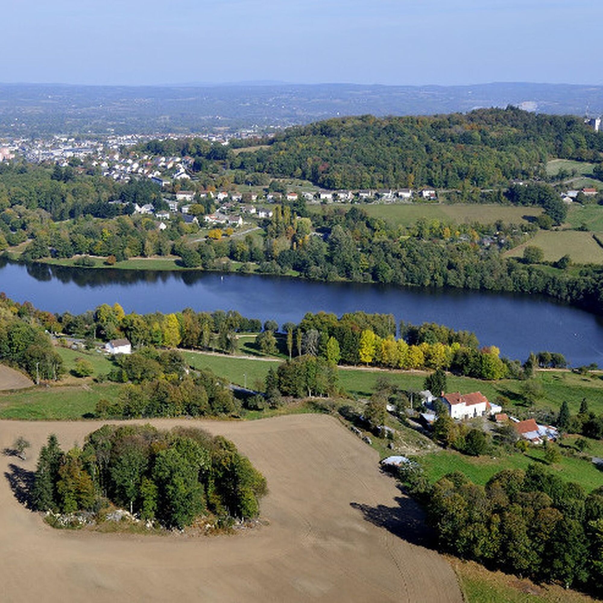
This 48.5 km route south of Guéret takes you through the Maupuy and Chabrières forest massifs. It can be completed in 2 days. In the course of challenging stages, you'll discover the stretcher stones,...
Opis
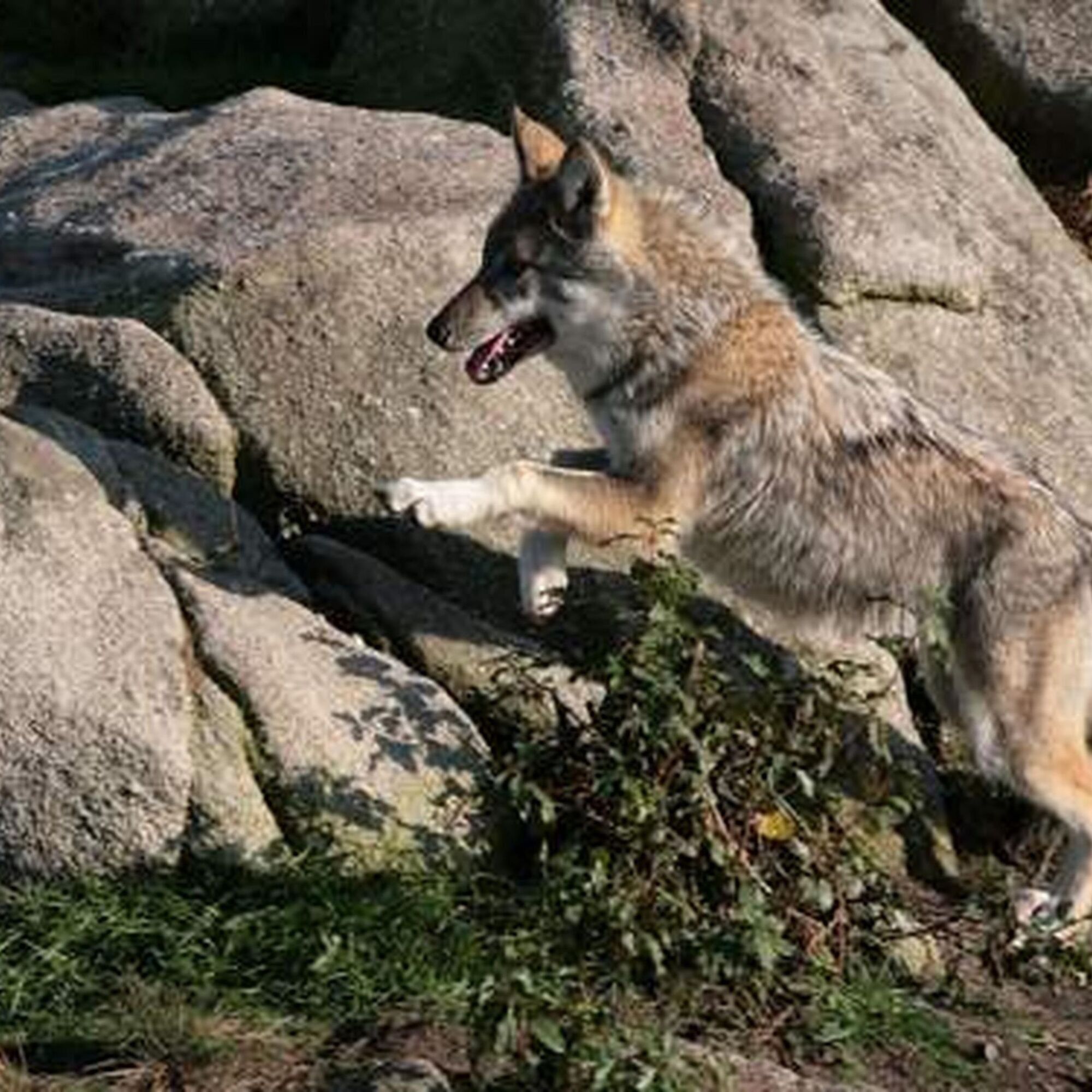
This 48.5 km route south of Guéret takes you through the Maupuy and Chabrières forest massifs. It can be completed in 2 days. In the course of challenging stages, you'll discover the stretcher stones, the arborétum of the Monts de Guéret, the legends of the Chabrières forest and its famous wolf park. It can easily be done in both directions.
This route is proposed by the Comité Régional de Randonnée Pédestre. Departing from a train station or TER bus stop, it allows you to join a walking or hiking itinerary and take a trip in ecomobility!
This route is proposed by the Comité Régional de Randonnée Pédestre. Departing from a train station or TER bus stop, it allows you to join a walking or hiking itinerary and take a trip in ecomobility!
Trasa
Guéret
(455 m)
Mesto
0,4 km
Puy de Gaudy
(651 m)
Summit
5,3 km
La Planche
(422 m)
Zúčtovanie
7,5 km
Savennes
(590 m)
Dedina
19,5 km
La Chapelle-Taillefert
(495 m)
Dedina
24,0 km
Puy de Chiroux
(689 m)
Summit
32,7 km
Église Saint-Pierre et Saint-Paul
(444 m)
Miesto uctievania
48,0 km
Trasa
GR®Pays Les Monts de Guéret : la boucle du Loup en écomobilité
ťažké
Turistika
48,17
km
Guéret
(455 m)
Mesto
0,4 km
Pommeil
(507 m)
Zúčtovanie
2,2 km
Le Theil
(489 m)
Zúčtovanie
3,1 km
La Faye
(481 m)
Zúčtovanie
3,3 km
Puy de Gaudy
(651 m)
Summit
5,3 km
Puy de Gaudy
(649 m)
Uhol pohľadu
5,5 km
Laspeyras
(471 m)
Zúčtovanie
6,9 km
Voust
(443 m)
Zúčtovanie
7,2 km
La Planche
(422 m)
Zúčtovanie
7,5 km
Peuplat
(435 m)
Zúčtovanie
7,9 km
Badant
(614 m)
Zúčtovanie
12,2 km
Les Vergnes
(555 m)
Zúčtovanie
18,0 km
Savennes
(590 m)
Dedina
19,5 km
Reillat
(583 m)
Zúčtovanie
20,2 km
Saint-Christophe
(506 m)
Dedina
21,6 km
Influence
(488 m)
Reštaurácia
24,0 km
La Chapelle-Taillefert
(495 m)
Dedina
24,0 km
Le Chier
(529 m)
Zúčtovanie
24,8 km
Rebeyrolle
(475 m)
Zúčtovanie
26,7 km
Saint-Victor-en-Marche
(479 m)
Dedina
28,4 km
Église Saint-Victor
(479 m)
Miesto uctievania
28,4 km
Le Chiroux
(541 m)
Zúčtovanie
31,3 km
Puy de Chiroux
(689 m)
Summit
32,7 km
Plage de Courtille
(464 m)
Reštaurácia
44,1 km
Guéret
(455 m)
Mesto
47,9 km
Église Saint-Pierre et Saint-Paul
(444 m)
Miesto uctievania
48,0 km
Autor
Poskytuje Tourisme Creuse
Prehliadku GR®Pays Les Monts de Guéret : la boucle du Loup en écomobilité zabezpečuje outdooractive.com.

Informácie o trase
Vhodné pre invalidné vozíky
Áno
Ďalšie informácie a tipy
Ďalšie informácie
Comité Régional de Randonnée Pédestre de Nouvelle-Aquitaine https://www.ffrandonnee-nouvelle-aquitaine.com/
Tipy
Yellow and red (GRP®)
cdt64.media.tourinsoft.eu/upload/bouc...
Zatiaľ žiadne recenzie
Obľúbené výlety v okolí
-
5,0
Circuit Pédestre N°15 CC : "Sur les pas des moines et des seigneurs"
svetloTuristika 10,2 km -
Creuse cycling route
strednáDiaľková cyklotrasa 324,5 km -
GRP des Monts de Guéret - Water loop
ťažkédiaľková pešia trasa 75,8 km -
Grande Traversée VTT de la Creuse (GT 23/First section)
strednáMountainbike 263,6 km -
GRP des Monts de Guéret - Wolf Loop
ťažkédiaľková pešia trasa 48,1 km -
Grande Traversée VTT de la Creuse (GT23/Second Section)
ťažkéMountainbike 260,7 km -
Mountain bike route No. 32 - Forêt de Chabrières
ťažkéMountainbike 16,5 km -
Trail Les rochers de Chabrières
strednáTrailrunning 20,3 km -
Circuit de randonnée pédestre n° 17 Le Maupuy et ses Pierres Civières
strednáTuristika 7,04 km -
Trail The Great Quarry
strednáTrailrunning 13,6 km
Turistika a stopovanie

Viac ako 550.000 návrhov výletov, podrobné mapy a intuitívny plánovač trás robia z aplikácie povinnú výbavu pre všetkých nadšencov prírody.

Nenechajte si ujsť ponuky a inšpiráciu na ďalšiu dovolenku
Prihlásiť sa k odberu noviniek
Chyba
Vyskytla sa chyba. Prosím, skúste to znova.
Ďakujeme za vašu registráciu
Vaša e-mailová adresa bol pridaný do poštového zoznamu.
Zájazdy po celej Európe
Rakúsko
Švajčiarsko
Nemecko
Taliansko
Slovinsko
Francúzsko
Holandsko
Belgicko
Poľsko
Lichtenštajnsko
Česko
Slovensko
španielsko
Hrvaška
Bosna a Hercegovina
Luxembursko
Andorra
Portugalsko
Island
Spojené kráľovstvo
Írsko
Grécko
Albánsko
Severné Macedónsko
Malta
Nórsko
Čierna Hora
Moldavsko
Kosovo
Maďarsko
San Maríno
Rumunsko
Estónsko
Lotyšsko
Bielorusko
Cyprus
Litva
Srbsko
Bulharsko
Monako
Dánsko
Švédsko
Fínsko