
Waldluftbadeweg Reisingerberg
svetlo
Získajte túto prehliadku v mobilnom telefóne
Waldluftbadeweg Reisingerberg
svetlo
Turistika
12,43
km
Naskenujte kód QR a spustite navigáciu v aplikácii bergfex


Turistika a stopovanie



Waldluftbadeweg Reisingerberg
svetlo
Vzdialenosť
12,4
km
Trvanie
03:58
h
Ascent
215
hm
Hladina mora
644 -
849
m

Naviguj sa počas prehliadky v aplikácii
Nainštalujte si aplikáciu zadarmo a sledujte trasu vďaka GPS navigácii a sledovaniu polohy.
Využite službu „ bergfex “ už teraz v aplikácii
Naskenuj QR kód pomocou fotoaparátu
Ak máte aplikáciu nainštalovanú, obsah sa otvorí priamo. Ak aplikáciu ešte nemáte, budete presmerovaní na stránku, kde si ju môžete bezplatne stiahnuť.
Stiahnutie skladby
Waldluftbadeweg Reisingerberg
svetlo
Turistika
12,43
km


Reisingerberg forest air bathing trail
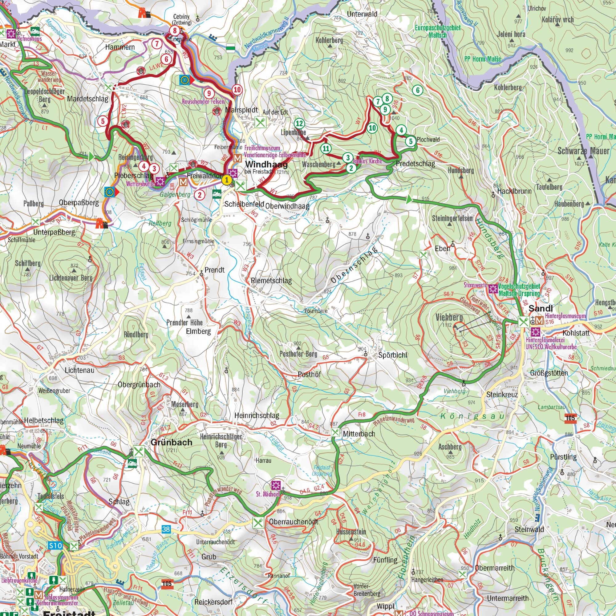
The trail leads us from the market square westwards past the Freiwald village, over the Galgenberg to the weather shuttle of the granite sculptor Gerhard Eilmsteiner....
Opis
Reisingerberg forest air bathing trail
The trail leads us from the market square westwards past the Freiwald village, over the Galgenberg to the weather shuttle of the granite sculptor Gerhard Eilmsteiner. The first destination on the hiking trail is Pieberschlag, where we can take our first break. Pieberschlag is located on the Reisingerberg, which we circle a bit. The Predigtstuhl, a rock overgrown with moss, lies slightly off the forest hiking trail. A few natural stone steps lead up to the Schalenstein.
The path continues past the summit of the Reisingerberg, which supplies the villages of Pieberschlag and Mardetschlag with vital energy. We then leave the forest. On the way to the village of Mardetschlag we find the Jankira. The rock behind the Pammer inn is an old legendary place with a pleasant, airy atmosphere.
We reach the village of Mardetschlag, where we can take another break. We then continue in the direction of Hammern, a village with forges and hammers on the Maltsch. Along the way we come across a large granite quarry. At the Lexmühle mill in Hammern, we cross the Maltsch and walk on the Bohemian side towards Mairspindt. An excursion to Cetviny (Zettwing) is highly recommended. Between the village of Hammern and the historic Maltsch bridge in Mairspindt is the six metre high "Rauschende Felsen" (rushing rock). At a certain spot by the rock, we hear the sound of a waterfall that seems to come from the rock.
At the historic stone bridge over the Maltsch to Zettwing is the mouth of the Felberbach stream into the Maltsch. Until the end of the 16th century, the Felberbach was called "Feldmaltsch" or "Steinmaltsch", the Maltsch itself "Waldmaltsch". The nearby village of Mairspindt was still called Malschgmündt in 1654, mhd. "gemünde" = "confluence". This is the strongest place with the element of water in the municipality.
After a rest at the Maltsch, we return to Windhaag along the Felberbach stream.
Reisingerberg forest air bathing trail - waypoints
1st hiking stone
2nd cross on the Galgenberg
3. Predigtstuhl and Schalenstein
4th Reisingerberg
5th Jankira
6. quarry
7th Hammern
8th Cetviny (Zettwing)
9. rushing rock
10. mouth of the Felberbach into the Maltsch
For guided tours please contact our qualified forest air bathing masters - more information can be found here.
Trasa
Windhaag bei Freistadt
(723 m)
Dedina
0,0 km
Pfarrkirche Windhaag
(723 m)
Miesto uctievania
0,0 km
Freiwalddorf
(765 m)
Zúčtovanie
0,8 km
Mardetschlag
(644 m)
Zúčtovanie
5,6 km
Hammern
(646 m)
Zúčtovanie
7,6 km
Narození Panny Marie
(652 m)
Miesto uctievania
8,3 km
Cetviny
(654 m)
Zúčtovanie
8,3 km
Trasa
Waldluftbadeweg Reisingerberg
svetlo
Turistika
12,43
km
Windhaag bei Freistadt
(723 m)
Dedina
0,0 km
Pfarrkirche Windhaag
(723 m)
Miesto uctievania
0,0 km
Freiwalddorf
(765 m)
Zúčtovanie
0,8 km
Pieberschlag
(786 m)
Zúčtovanie
1,4 km
Panoramablick
(841 m)
Uhol pohľadu
2,1 km
Mardetschlag
(644 m)
Zúčtovanie
5,6 km
Hammern
(646 m)
Zúčtovanie
7,6 km
Narození Panny Marie
(652 m)
Miesto uctievania
8,3 km
Cetviny
(654 m)
Zúčtovanie
8,3 km
Windhaag bei Freistadt
(723 m)
Dedina
12,4 km
Autor
Poskytuje Destination Mühlviertel
Prehliadku Waldluftbadeweg Reisingerberg zabezpečuje outdooractive.com.




Zatiaľ žiadne recenzie
Obľúbené výlety v okolí
-
4,4
10-Mühlen-Wanderweg Reichenthal
svetloTuristika 14,2 km -
4,6
Sandl - Rosenhoferteiche Rundweg
svetloTuristika 6,40 km -
3,9
Rundweg Thurytal-Vierzehn-Freistadt
svetloTuristika 8,50 km -
3,6
Zwei-Tausender-Tour Tischberg-Eichelberg
svetloTuristika 12,4 km -
4,4
Windhaag bei Freistadt - W1, Österreich
svetloTuristika 11,6 km -
5,0
Sandl - S2 - Rosenhof Rundweg
svetloTuristika 3 km -
3,0
Weg O3 Maria Bründl - Braunbergweg
svetloTuristika 8,52 km -
4,0
Lasberg - La7 - Braunberg
svetloTuristika 5,20 km -
3,8
Hussensteinweg
svetloTuristika 11,6 km -
3,7
Müllerrundweg
svetloTuristika 6,28 km
Turistika a stopovanie

Viac ako 550.000 návrhov výletov, podrobné mapy a intuitívny plánovač trás robia z aplikácie povinnú výbavu pre všetkých nadšencov prírody.

Nenechajte si ujsť ponuky a inšpiráciu na ďalšiu dovolenku
Prihlásiť sa k odberu noviniek
Chyba
Vyskytla sa chyba. Prosím, skúste to znova.
Ďakujeme za vašu registráciu
Vaša e-mailová adresa bol pridaný do poštového zoznamu.
Zájazdy po celej Európe
Rakúsko
Švajčiarsko
Nemecko
Taliansko
Slovinsko
Francúzsko
Holandsko
Belgicko
Poľsko
Lichtenštajnsko
Česko
Slovensko
španielsko
Hrvaška
Bosna a Hercegovina
Luxembursko
Andorra
Portugalsko
Island
Spojené kráľovstvo
Írsko
Grécko
Albánsko
Severné Macedónsko
Malta
Nórsko
Čierna Hora
Moldavsko
Kosovo
Maďarsko
San Maríno
Rumunsko
Estónsko
Lotyšsko
Bielorusko
Cyprus
Litva
Srbsko
Bulharsko
Monako
Dánsko
Švédsko
Fínsko


