Téroundel path (Sentier du Téroundel)
svetlo
Získajte túto prehliadku v mobilnom telefóne
Téroundel path (Sentier du Téroundel)
svetlo
Turistika
2,58
km
Naskenujte kód QR a spustite navigáciu v aplikácii bergfex

Turistika a stopovanie


Téroundel path (Sentier du Téroundel)
svetlo
Vzdialenosť
2,58
km
Trvanie
01:30
h
Ascent
77
hm
Hladina mora
228 -
307
m
Stiahnutie skladby
Téroundel path (Sentier du Téroundel)
svetlo
Turistika
2,58
km
Local toponymy provides some insights into the geography: on the communal land register, the names Téroundel (the hill's name) and Térondel (point 4 on the map) appear. These names, common in the region,...
Opis
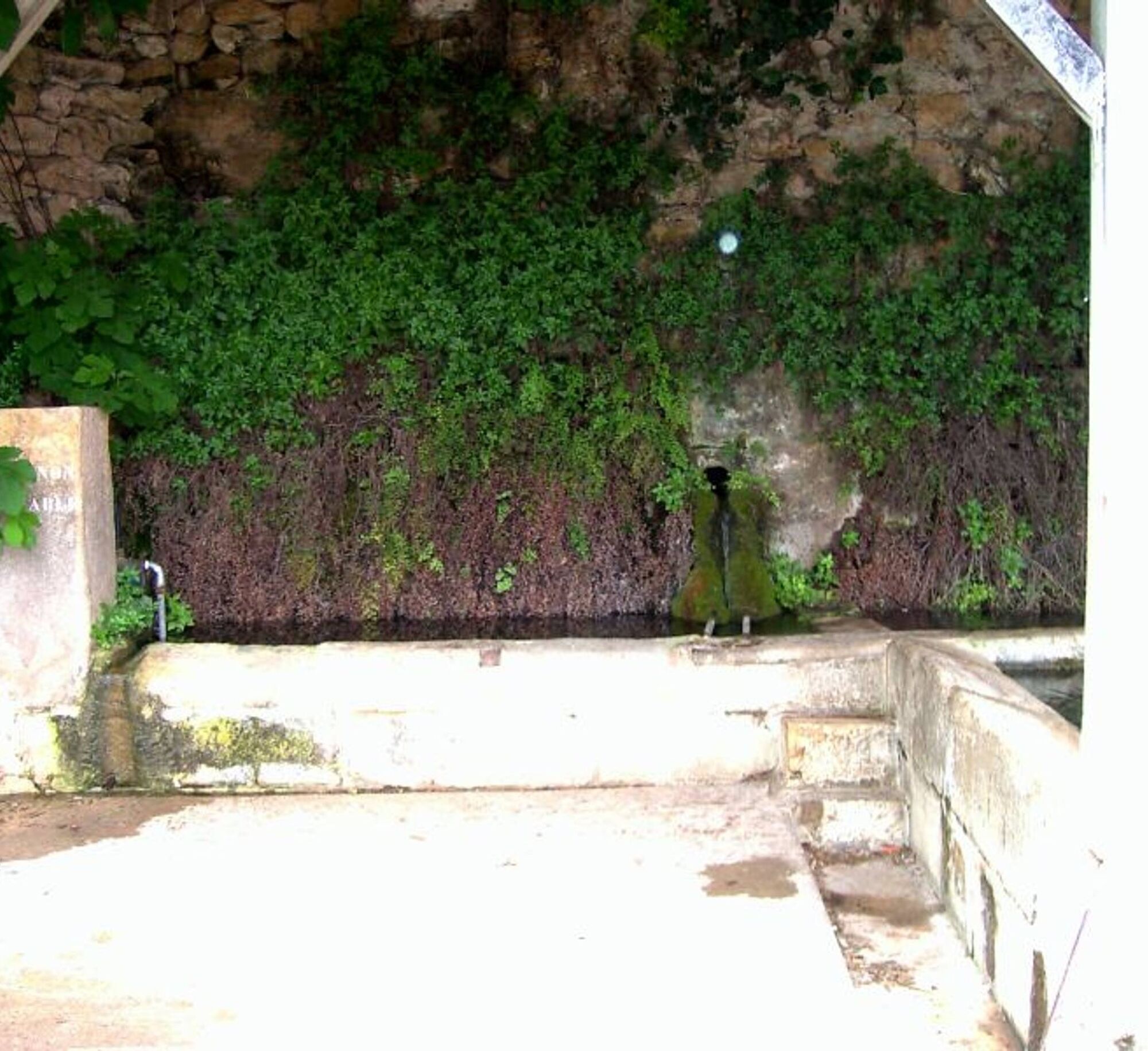
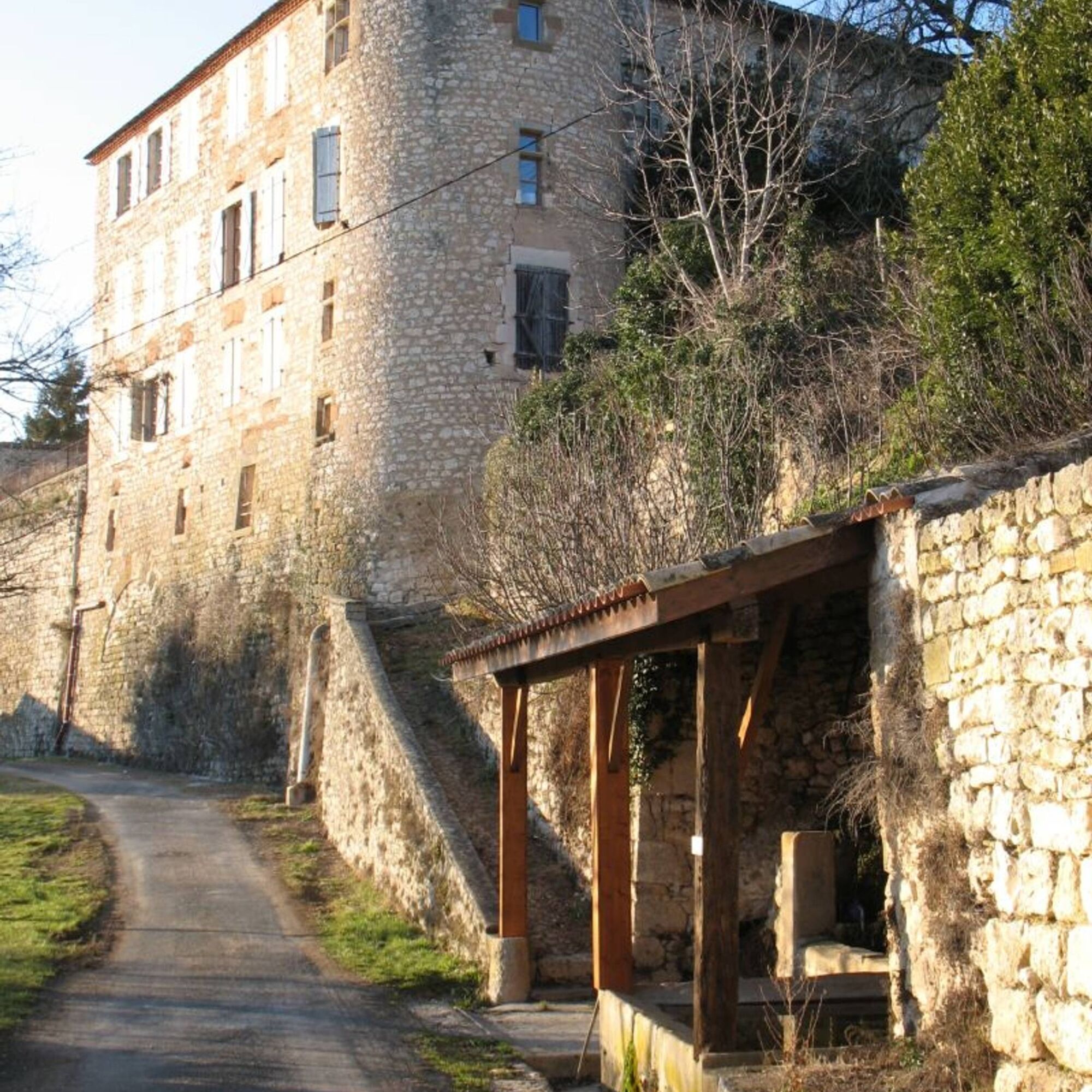
Local toponymy provides some insights into the geography: on the communal land register, the names Téroundel (the hill's name) and Térondel (point 4 on the map) appear. These names, common in the region, come from the Latin "turo," meaning height. This should not be confused with "Thouron," which comes from Occitan and refers to a place near a fountain or spring, such as the Thouron washhouse at the foot of the castle, which houses the rare and protected plant, Capillaire de Montpellier, also known as "Venus hair." Another washhouse is located at the end of the arched bridge. By crossing the road, you will also find old watering troughs.
You will walk for a while on the Sentier des Plaideurs. Before the unification of the villages of Mouzieys and Panens (1810), the people of Panens would discreetly travel to Cordes along this path. Hidden from the villagers of Mouzieys by the embankment and crops, they would go to report minor disputes to the judge of Cordes.
You will walk for a while on the Sentier des Plaideurs. Before the unification of the villages of Mouzieys and Panens (1810), the people of Panens would discreetly travel to Cordes along this path. Hidden from the villagers of Mouzieys by the embankment and crops, they would go to report minor disputes to the judge of Cordes.
Trasa
Trasa
Téroundel path (Sentier du Téroundel)
svetlo
Turistika
2,58
km
Autor
Poskytuje Tarn Tourisme
Prehliadku Téroundel path (Sentier du Téroundel) zabezpečuje outdooractive.com.

Informácie o trase
Trasa
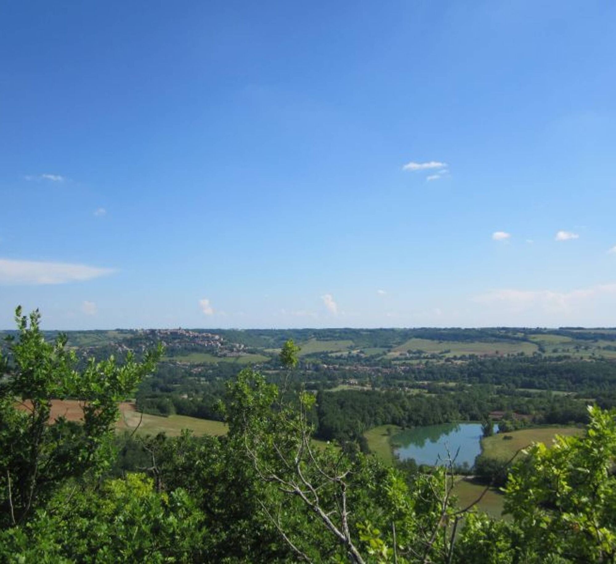
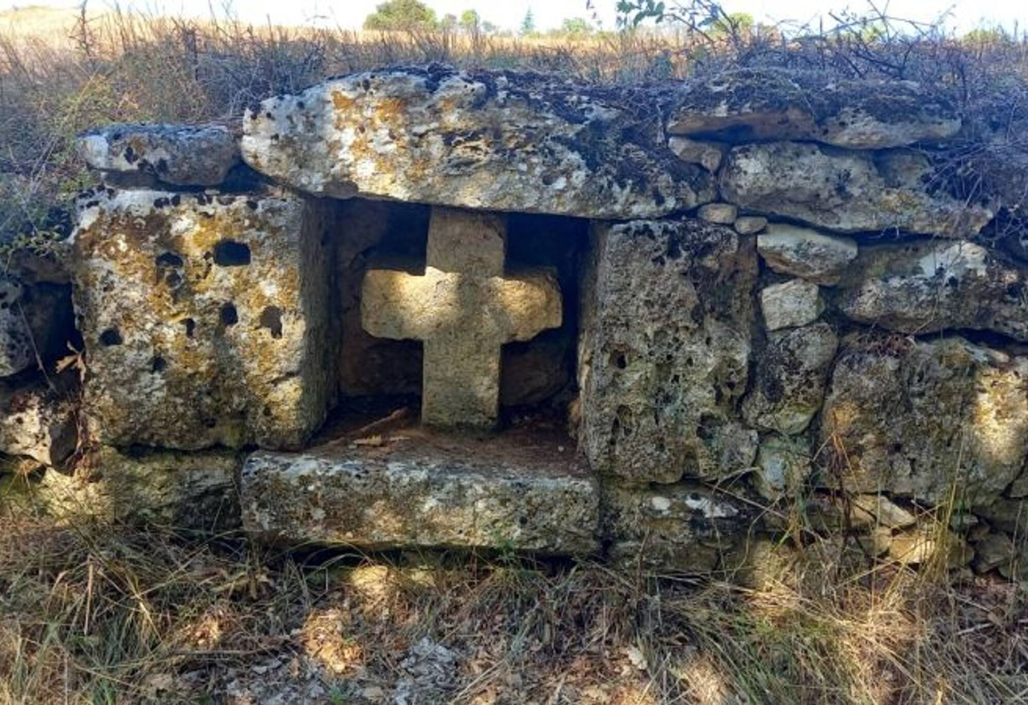
1. The walk starts in front of the castle entrance, heading into the countryside along the beautiful tree-lined avenue recently named "Lice des créneaux." You will see several dovecotes, including the one on the right at the large farm "La Peyrière." Continue straight on the path through the fields. 2. At the end of the path, before turning right onto the Chemin des Plaideurs, move towards the left to discover a beautiful white stone cross hidden in the embankment. Descend the Chemin des Plaideurs and take the small hillside path to the right, which overlooks a private agricultural path. A bit further on, follow this agricultural path for 40 meters. Then, turn left onto the small path that descends to the bottom of the hill. Along your route, you will pass an olive grove and catch glimpses of the striking profile of Cordes-sur-Ciel through the trees. 3. This relatively flat and shaded area offers you the chance to take a break before starting the return journey to the village. Follow the small path that climbs halfway up the slope. You will come across numerous installations for olive cultivation. In the distance, you will see the Château de Mouzieys and the arched bridge. This rather unique bridge was built 150 years ago to support the new road between Cordes-sur-Ciel and Mouzieys-Panens. 4. When you reach the road, if you wish to finish your circuit directly, continue straight and then turn left at the intersection to return to your starting point in front of the castle.
Discovery detour: from point 4, turn right to take the road towards Térondel, then the small path to admire the magnificent panorama of Cordes and the Cérou valley at the southern end of the plateau (about 1 km - 15 min round trip). Returning on your steps, continue a few meters towards the village, then turn left to arrive below the castle. There you will find the Thouron washhouse. Its three clear water basins will allow you to refresh yourself before returning to the starting point via the stony path that runs along the castle
Discovery detour: from point 4, turn right to take the road towards Térondel, then the small path to admire the magnificent panorama of Cordes and the Cérou valley at the southern end of the plateau (about 1 km - 15 min round trip). Returning on your steps, continue a few meters towards the village, then turn left to arrive below the castle. There you will find the Thouron washhouse. Its three clear water basins will allow you to refresh yourself before returning to the starting point via the stony path that runs along the castle
Ďalšie informácie a tipy
Ďalšie informácie
Very easy
Zatiaľ žiadne recenzie
Obľúbené výlety v okolí
-
5,0
Chemin de la Vère au Saint-Hussou
strednáTuristika 14,2 km -
Maraval Trail - Short Variant
strednáTuristika 5,02 km -
Sentier des dunes de Maraval aux Touardes
strednáTuristika 8,57 km -
Grain of salt path (Chemin du grain de sel)
strednáTuristika 10,6 km -
Maraval trail - dune section
svetloTuristika 1,72 km -
From the Cérou to the Aveyron
strednáTuristika 10,2 km -
Sentier de découverte de Les Cabannes "Sur les traces des bâtisseurs"
svetloTuristika 2,63 km -
Vignoble et châteaux
ťažkéTuristika 17,4 km -
Cordes heritage trail
strednáTuristika 14,8 km -
Sentier des quatre châteaux
strednáTuristika 14,0 km

Turistika a stopovanie

Viac ako 550.000 návrhov výletov, podrobné mapy a intuitívny plánovač trás robia z aplikácie povinnú výbavu pre všetkých nadšencov prírody.

Nenechajte si ujsť ponuky a inšpiráciu na ďalšiu dovolenku
Prihlásiť sa k odberu noviniek
Chyba
Vyskytla sa chyba. Prosím, skúste to znova.
Ďakujeme za vašu registráciu
Vaša e-mailová adresa bol pridaný do poštového zoznamu.
Zájazdy po celej Európe
Rakúsko
Švajčiarsko
Nemecko
Taliansko
Slovinsko
Francúzsko
Holandsko
Belgicko
Poľsko
Lichtenštajnsko
Česko
Slovensko
španielsko
Hrvaška
Bosna a Hercegovina
Luxembursko
Andorra
Portugalsko
Island
Spojené kráľovstvo
Írsko
Grécko
Albánsko
Severné Macedónsko
Malta
Nórsko
Čierna Hora
Moldavsko
Kosovo
Maďarsko
San Maríno
Rumunsko
Estónsko
Lotyšsko
Bielorusko
Cyprus
Litva
Srbsko
Bulharsko
Monako
Dánsko
Švédsko
Fínsko