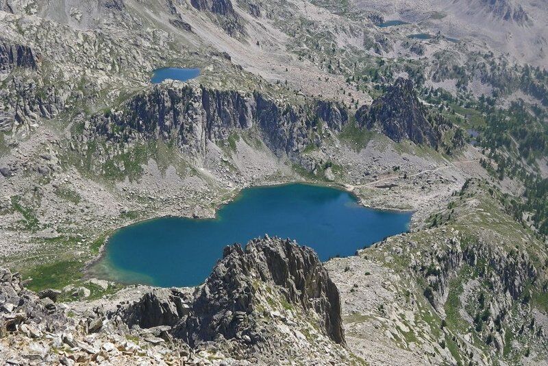
Lac Nègre
stredná
Navigácia na stránke
Navigácia na stránke
Získajte túto prehliadku v mobilnom telefóne
Lac Nègre
stredná
Turistika
7,49
km
Naskenujte kód QR a spustite navigáciu v aplikácii bergfex

Turistika a stopovanie


Lac Nègre
stredná
Vzdialenosť
7,49
km
Trvanie
05:00
h
Ascent
640
hm
Hladina mora
1 670 -
2 357
m
Stiahnutie skladby
Lac Nègre
stredná
Turistika
7,49
km
Take GR52 along the right bank of the Salèse Valley before reaching the Col de Salèse.When you get there, follow the path which heads upwards on the right towards Lac Nègre.At marker 270, go left and continue...
Opis
Take GR52 along the right bank of the Salèse Valley before reaching the Col de Salèse.When you get there, follow the path which heads upwards on the right towards Lac Nègre.At marker 270, go left and continue towards Lac Nègre with its panoramic views.Take the same route for the return journey.
For those who wish, there is the possibility of a detour via Camp Soubran, reaching the Col de Frémamorte (this will take 3 extra hours for the outward and return journey).
For those who wish, there is the possibility of a detour via Camp Soubran, reaching the Col de Frémamorte (this will take 3 extra hours for the outward and return journey).
Trasa
Camp Soubran
(2 270 m)
Koridor/terén
6,7 km
Trasa
Lac Nègre
stredná
Turistika
7,49
km
Camp Soubran
(2 270 m)
Koridor/terén
6,7 km

Informácie o trase
Jednosmerná prehliadka
Áno
Ďalšie informácie a tipy
Ďalšie informácie
Difficulté = Medium
Zatiaľ žiadne recenzie
Obľúbené výlety v okolí
-
The Salt Roads: The Pagarine Route
strednádiaľková pešia trasa 159,7 km -
VTT FFC route no. 2: The Férisson dairy farm
ťažkéMountainbike 28,0 km -
Auron - Nice gravel route
ťažkéDiaľková cyklotrasa 364,4 km -
Giro dell'Argentera ski
ťažkéSkitour 28,6 km -
Circuit Valdebore - Col de la Medleine - St. Dalmas - Valdebore, Provence-Alpes-Côte d'Azur/Frankreich
strednáTuristika 12,2 km -
Mercantour to Nice Electric Mountain Bike Route "e-bike MNCA"
strednáMountainbike 236,3 km -
5,0
Goldtoni - Alpenbogen A105 Refuge de la Modena de Fenestre-Refugio Morelli Buzzi
strednádiaľková pešia trasa 24,8 km -
The Madonna of Fenestre - San Giacomo di Entracque / Pagarine route (stage 7)
strednáTuristika 13,3 km -
5,0
Goldtoni - Alpenbogen A104 Refuge des Merveilles-Refuge de la Modena de Fenestre
strednádiaľková pešia trasa 18,6 km -
5,0
Goldtoni - Alpenbogen A107 Refugio Malinvern-Strepeis
strednádiaľková pešia trasa 25,9 km
Turistika a stopovanie

Viac ako 550.000 návrhov výletov, podrobné mapy a intuitívny plánovač trás robia z aplikácie povinnú výbavu pre všetkých nadšencov prírody.

Nenechajte si ujsť ponuky a inšpiráciu na ďalšiu dovolenku
Prihlásiť sa k odberu noviniek
Chyba
Vyskytla sa chyba. Prosím, skúste to znova.
Ďakujeme za vašu registráciu
Vaša e-mailová adresa bol pridaný do poštového zoznamu.
Zájazdy po celej Európe
Rakúsko
Švajčiarsko
Nemecko
Taliansko
Slovinsko
Francúzsko
Holandsko
Belgicko
Poľsko
Lichtenštajnsko
Česko
Slovensko
španielsko
Hrvaška
Bosna a Hercegovina
Luxembursko
Andorra
Portugalsko
Island
Spojené kráľovstvo
Írsko
Grécko
Albánsko
Severné Macedónsko
Malta
Nórsko
Čierna Hora
Moldavsko
Kosovo
Maďarsko
San Maríno
Rumunsko
Estónsko
Lotyšsko
Bielorusko
Cyprus
Litva
Srbsko
Bulharsko
Monako
Dánsko
Švédsko
Fínsko