


Sentier des bouquetins


Fotografie našich používateľov
The Steinbocks Trail (Sentier des Bouquetins) is a themed route that provides information about the pioneering Grande Dixence project, covering topics such as flora and fauna, history, and geology around...
The Steinbocks Trail (Sentier des Bouquetins) is a themed route that provides information about the pioneering Grande Dixence project, covering topics such as flora and fauna, history, and geology around Europe’s highest gravity dam. The path was inaugurated in 2012 and runs along seven stops – including the Cabane de Prafleuri, which is suitable for a refreshment break.
Details of the hike can be found in a brochure (available at the tourist office or as a download in German, French, and English).
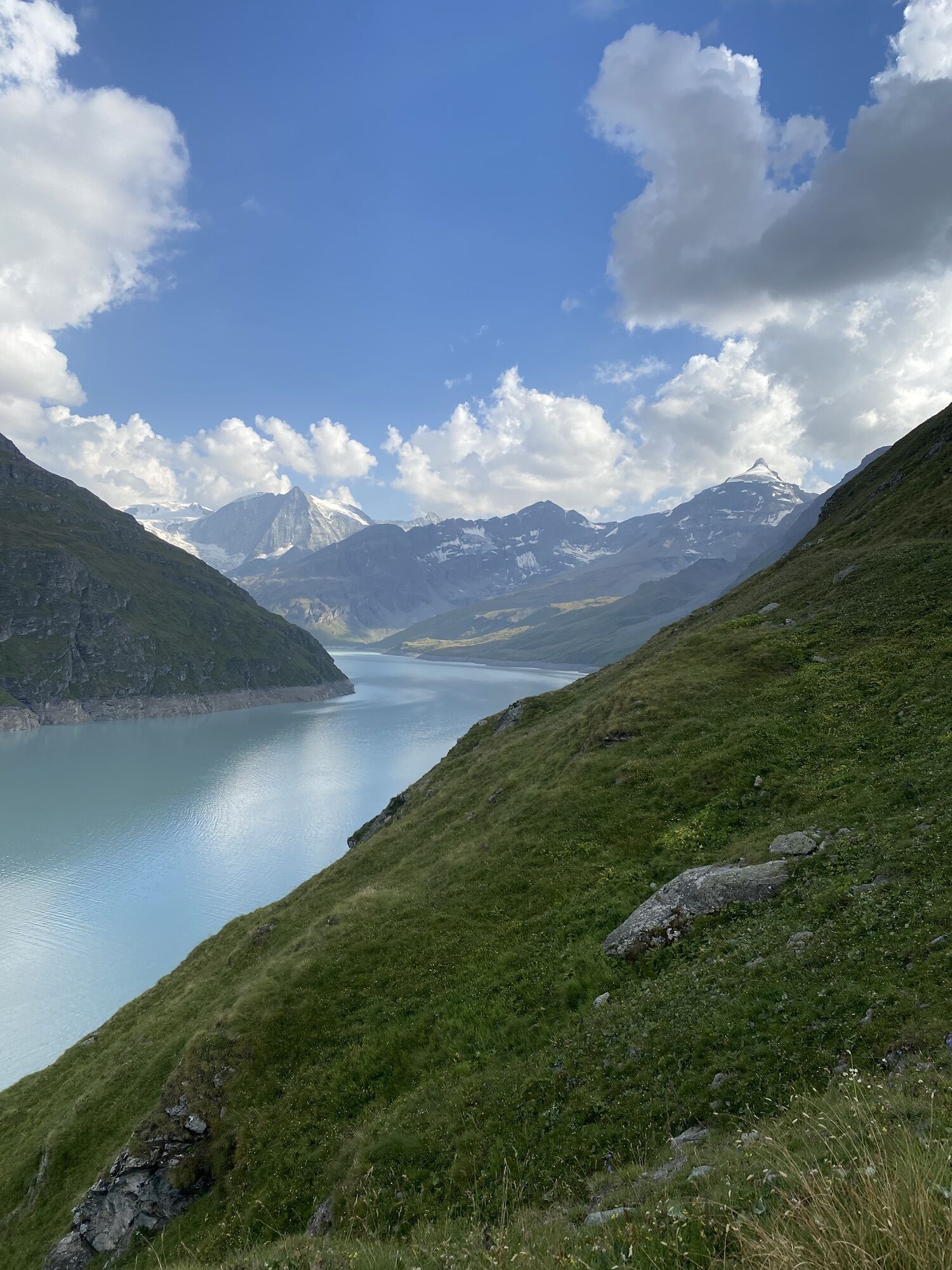
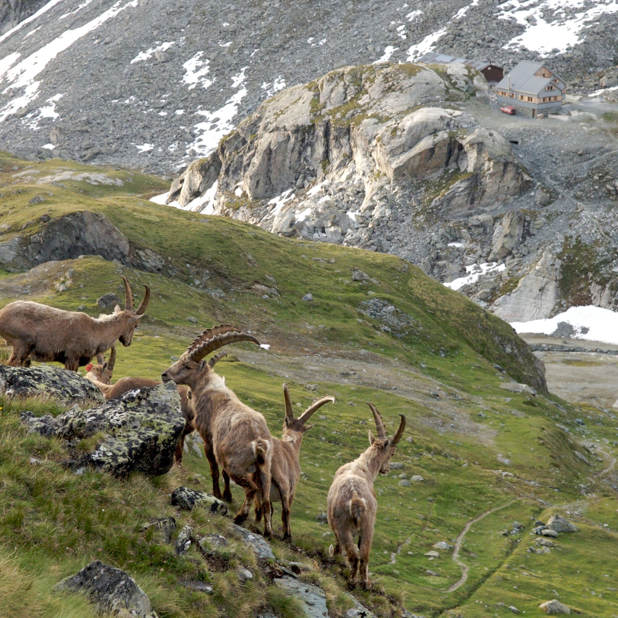
The route begins at the dam’s crown and initially follows the reservoir through several tunnels. A climb through blooming alpine pastures leads to the Col des Roux at 2803 m above sea level and offers good opportunities to observe ibex. These wild relatives of the domestic goat are recognizable by their large horns.
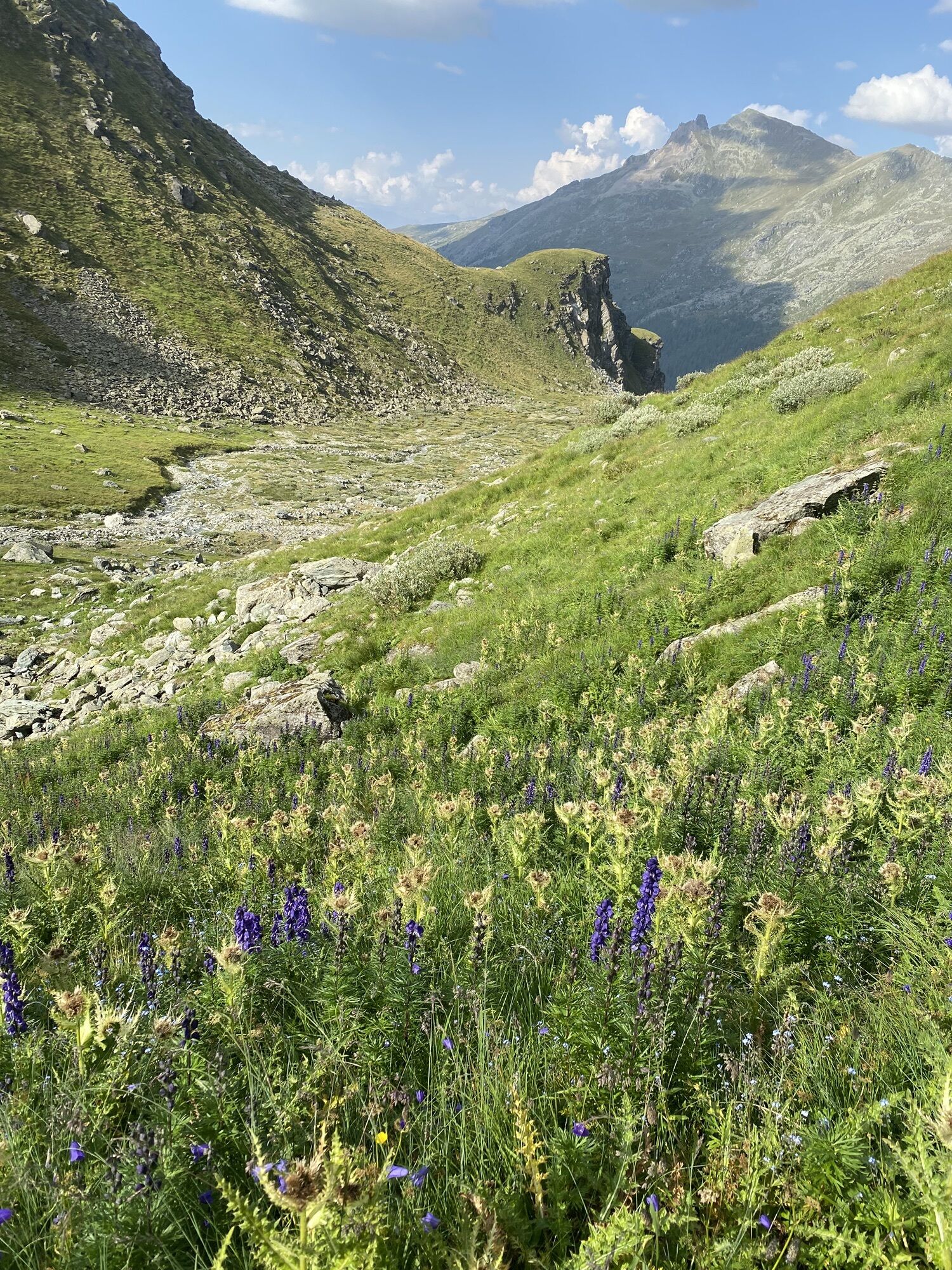
On the other side of the pass lies the small side valley Combe de Prafleuri. The rock material of the glacial moraines was used as raw material for the dam. From 1952, around 500 workers lived here for 8 years in a temporary village with twenty wooden huts while the dam was being built. Only one hut remains – the sole witness to one of the largest construction sites Switzerland has ever known. The hut served temporarily as a mountain hut until the new Cabane de Prafleuri was built next to it in 2000.
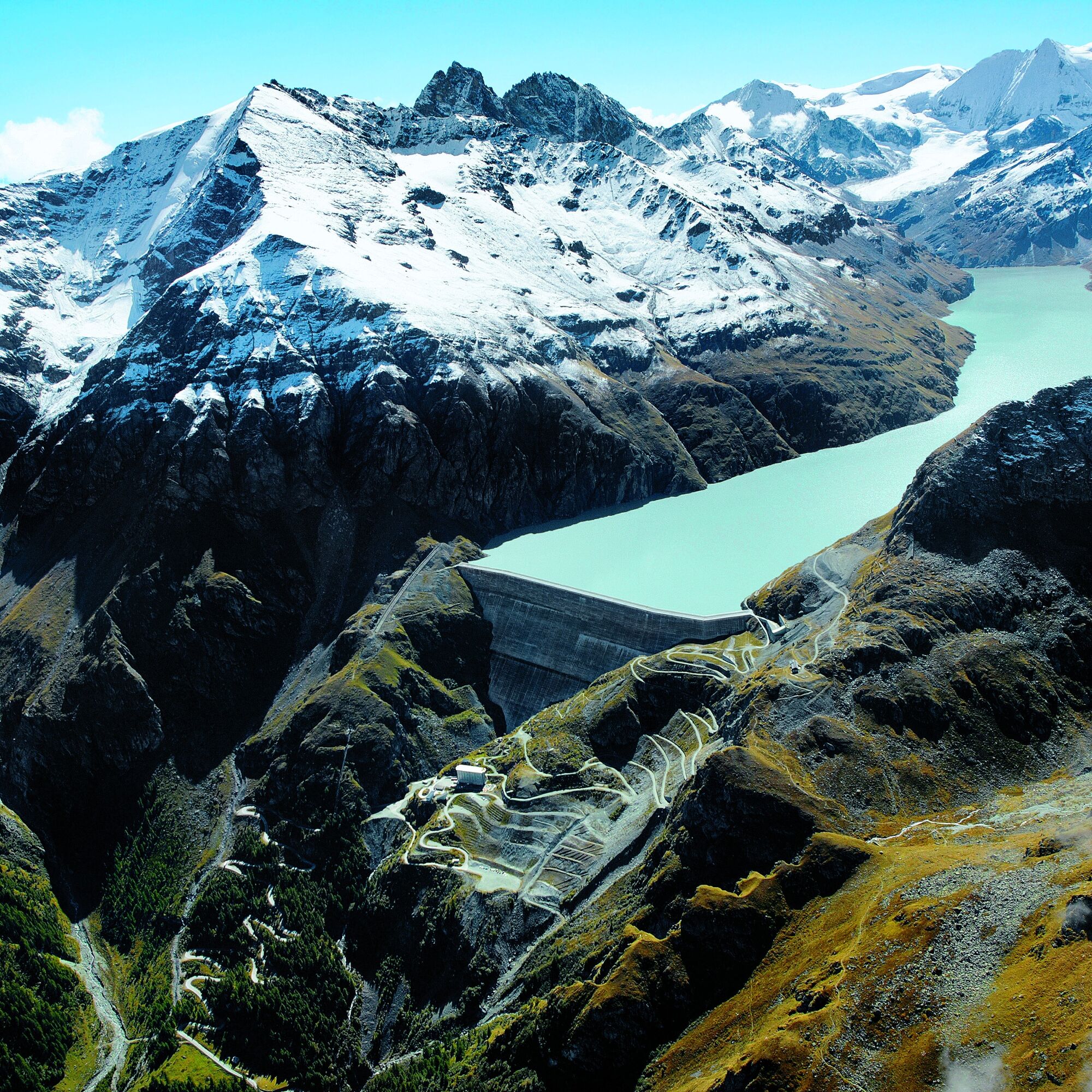
The engineering highlight, of course, is the dam itself: at 285 m high, it is the tallest gravity dam in Europe. The dam’s visitor center organizes guided tours inside the structure. A network of reservoirs, underground tunnels, pumping stations, and power plants together form
the largest hydropower complex in Switzerland.
Highlights of the route
Detailed themed route about hydropower, flora and fauna, and the history of the dam. Grande Dixence, Europe’s highest gravity dam with visitor center and aerial cableway. The hike along Lac des Dix passes through numerous tunnels along Switzerland’s largest reservoir.

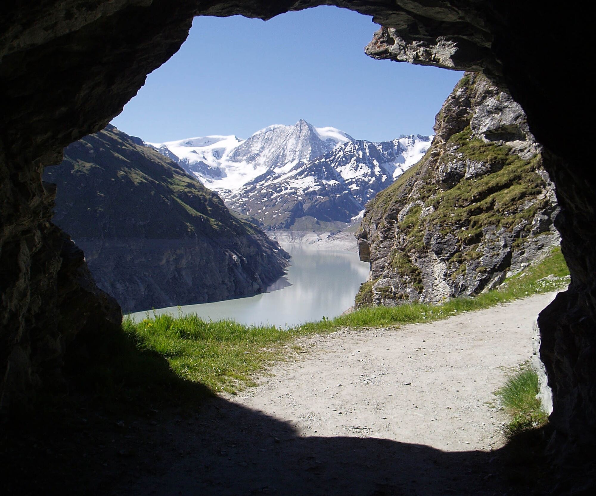
The path begins at the mountain station of the Grande Dixence aerial cableway and leads directly to the crown of the dam. Along the western shore of the reservoir, the path first goes through some tunnels and then over alpine pastures before ascending steeply to the highest point of the route. From the Col des Roux at 2803 m above sea level, it then descends into the side valley Combe de Prafleuri. The staff at the Cabane de Prafleuri offer refreshments. From here, the path descends steeply along the flank of the valley until the impressive dam and the reservoir come back into view. The path zigzags back to the dam crown.
To get from the foot of the dam to the crown, you can either take the aerial cableway or walk (approximately 45 minutes).
Áno
Áno
We recommend:
Good footwear Weather-dependent clothing: always carry a waterproof vest Head covering Sun protection Water bottle Picnic Camera Binoculars (optional) Walking poles (optional) Printout of the hiking trail (click "Print" to download)
For certain hikes:
Swimsuit
The mountains, a place of joy to share and respect. The mountain world is a place to meet and experience unforgettable moments together – whether on a bike or on foot. So that all users can benefit, it is essential to share this space with respect for nature and agriculture. Respectful behavior enables everyone to enjoy their leisure activities under the best conditions. Inform yourself about recommendations and rules. Assess your own skills and fitness carefully. Use of the various routes is fundamentally at your own risk.
For all hikes:
Carry a map with you. Download the complete description of the hiking trail with a large-scale map by clicking "Print" at the top right of the page. Use only marked hiking trails and observe all signs and instructions - for your own safety, to protect grazing animals, and out of respect for wildlife. Close gates after passing through. Behave considerately towards other trail users, plants, and animals.
For mountain hikes:
Carry additional sun protection. UV rays at high altitudes can be very strong, even in overcast weather. Plan your hike carefully: consider the required fitness level of all participants, weather forecasts, and seasonal dependencies. The weather conditions in the mountains can change rapidly and without warning. Proper clothing and sufficient provisions (food and drink) are very important. In unstable weather, it is better to turn back early.
For high-alpine hikes:
Inform your family about your hiking route. If possible, avoid going alone. Do not venture onto glaciers without a mountain guide. Observe warning signs indicating dangers at riverbanks, along watercourses below dams and reservoirs: Water levels can rise quickly and without warning.
Motorway A9 to exit 27 (Sion-Est). Follow the signs towards Vex, Hérémence and Grande Dixence.
Regular train connections to Sion. Then take the post bus to Grande Dixence. Timetables for trains and post buses can be found at sbb.ch.
Parking is available at the foot of the dam.
More information about the destination:Hérémence
Call the visitor center and register for a guided tour inside the dam. Guided tours are offered daily during the summer months (mid-June – September).
Obľúbené výlety v okolí
-
Arolla - Vignettes
strednáSkitour 5,04 km -
2,0
Circular hike to Cabane des Aiguilles Rouges and Lac Bleu
ťažkéTuristika 14,1 km -
From Savoleyres to the mountain lake Lac des Vaux
strednáTuristika 14,0 km -
4,0
Sentier des Chamois
ťažkéTuristika 11,6 km -
4,5
Cleuson Dam
strednáTuristika 11,5 km -
Zum Fuss des Gletschers und zurück nach Les Hauderes
strednáTuristika 12,3 km -
3,0
Via ferrata in the Mauvoisin Gorge
strednáVia ferrata 1,77 km -
4,0
Balade sur la Bisse Vieux
svetloTuristika 5,33 km -
Around the Mauvoisin reservoir
ťažkéTuristika 22,0 km -
From Cabane Brunet to Cabane FXB Panossière
strednáTuristika 6,87 km
Turistika a stopovanie


Nenechajte si ujsť ponuky a inšpiráciu na ďalšiu dovolenku
Vaša e-mailová adresa bol pridaný do poštového zoznamu.