M3 Mountain Bike Tour from Monsols to St. Igny
ťažké
Získajte túto prehliadku v mobilnom telefóne
M3 Mountain Bike Tour from Monsols to St. Igny
ťažké
Mountainbike
36,29
km
Naskenujte kód QR a spustite navigáciu v aplikácii bergfex

Turistika a stopovanie


M3 Mountain Bike Tour from Monsols to St. Igny
ťažké
Vzdialenosť
36,29
km
Trvanie
03:15
h
Ascent
984
hm
Hladina mora
507 -
1 002
m
Stiahnutie skladby
M3 Mountain Bike Tour from Monsols to St. Igny
ťažké
Mountainbike
36,29
km
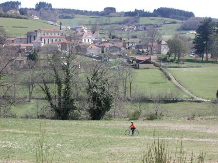
This very sporty and technical trail gives you the opportunity to do the grand tour of the St-Rigaud massif. Beware, there are several tricky passages, two passes and a summit ahead. However, you will...
Opis
This very sporty and technical trail gives you the opportunity to do the grand tour of the St-Rigaud massif. Beware, there are several tricky passages, two passes and a summit ahead. However, you will be able to enjoy the rolling hills and beautiful views, especially at the top where there is a spring to quench your thirst.
Trasa
Col de la Croix des Oncins
(700 m)
Horské sedlo
2,1 km
Mont Saint-Rigaud
(1 009 m)
Summit
10,1 km
Église de la Nativité-de-Saint-Jean-Baptiste
(540 m)
Miesto uctievania
23,4 km
Terres de la Cour et Ebourne
(608 m)
Koridor/terén
24,0 km
Le Plat
(648 m)
Zúčtovanie
28,2 km
Les Charbonniers
(566 m)
Zúčtovanie
34,0 km
Monsols
(536 m)
Dedina
34,1 km
Trasa
M3 Mountain Bike Tour from Monsols to St. Igny
ťažké
Mountainbike
36,29
km
Col de la Croix des Oncins
(700 m)
Horské sedlo
2,1 km
Croix des Oncins
(700 m)
Koridor/terén
2,2 km
Source du Mont Saint-Rigaud
(965 m)
Zdroj
9,7 km
Mont Saint-Rigaud
(1 009 m)
Summit
10,1 km
Bois des Aguets
(850 m)
Koridor/terén
12,0 km
Les Canots
(691 m)
Zúčtovanie
15,5 km
Guillotière
(532 m)
Koridor/terén
22,3 km
Saint-Igny-de-Vers
(540 m)
Dedina
23,3 km
Église de la Nativité-de-Saint-Jean-Baptiste
(540 m)
Miesto uctievania
23,4 km
Auberge du Sornin
(539 m)
Reštaurácia
23,4 km
Terres de la Cour et Ebourne
(608 m)
Koridor/terén
24,0 km
Le Plat
(648 m)
Zúčtovanie
28,2 km
Croisement des Fonderies
(604 m)
Koridor/terén
32,7 km
Breté
(585 m)
Koridor/terén
33,6 km
Les Charbonniers
(566 m)
Zúčtovanie
34,0 km
Monsols
(536 m)
Dedina
34,1 km
Chonay
(577 m)
Susedstvo
34,8 km
Autor
Poskytuje Rhône Tourisme
Prehliadku M3 Mountain Bike Tour from Monsols to St. Igny zabezpečuje outdooractive.com.
Ďalšie informácie a tipy
Ďalšie informácie
APIDAE Tourism data updated on 02/03/2021 by "Destination Beaujolais".
An error on this sheet? Write to the owner by recalling these references:
Sheet name: VTT Circuit M13 from Monsols to St Igny | Sheet ID: 162079 | URL (link) of this Outdooractive page.
An error on this sheet? Write to the owner by recalling these references:
Sheet name: VTT Circuit M13 from Monsols to St Igny | Sheet ID: 162079 | URL (link) of this Outdooractive page.
Zatiaľ žiadne recenzie
Obľúbené výlety v okolí
-
De l’Aze à l’Ergues - Beaujolais Vert - Claveisolles
svetloTuristika 13,0 km -
CycloRoute71 - Etape 11 de La Clayette à Cluny
strednáCyklistika 56,8 km -
5,0
B3 Mountain Bike Tour from Beaujeu to St Didier/Beaujeu
ťažkéMountainbike 22,6 km -
La balade des rhododendrons
svetloJazda na koni 6,60 km -
Circuit des digitales
strednáTuristika 13,6 km -
B9 Mountain Bike Tour Marchampt
ťažkéMountainbike 19,8 km -
The Beaujolais vineyard - Beaujolais - Chiroubles
svetloTuristika 12,5 km -
Boucle intercommunale
strednáTuristika 75,0 km -
Sentier botanique
svetloJazda na koni 5,76 km -
M12 Mountain Bike Tour B2 from Monsols to Ouroux
ťažkéMountainbike 22,5 km

Turistika a stopovanie

Viac ako 550.000 návrhov výletov, podrobné mapy a intuitívny plánovač trás robia z aplikácie povinnú výbavu pre všetkých nadšencov prírody.

Nenechajte si ujsť ponuky a inšpiráciu na ďalšiu dovolenku
Prihlásiť sa k odberu noviniek
Chyba
Vyskytla sa chyba. Prosím, skúste to znova.
Ďakujeme za vašu registráciu
Vaša e-mailová adresa bol pridaný do poštového zoznamu.
Zájazdy po celej Európe
Rakúsko
Švajčiarsko
Nemecko
Taliansko
Slovinsko
Francúzsko
Holandsko
Belgicko
Poľsko
Lichtenštajnsko
Česko
Slovensko
španielsko
Hrvaška
Bosna a Hercegovina
Luxembursko
Andorra
Portugalsko
Island
Spojené kráľovstvo
Írsko
Grécko
Albánsko
Severné Macedónsko
Malta
Nórsko
Čierna Hora
Moldavsko
Kosovo
Maďarsko
San Maríno
Rumunsko
Estónsko
Lotyšsko
Bielorusko
Cyprus
Litva
Srbsko
Bulharsko
Monako
Dánsko
Švédsko
Fínsko