Le Beaujolais Vert - Around the summits of Beaujolais - Loop 3.1
ťažké
Získajte túto prehliadku v mobilnom telefóne
Le Beaujolais Vert - Around the summits of Beaujolais - Loop 3.1
ťažké
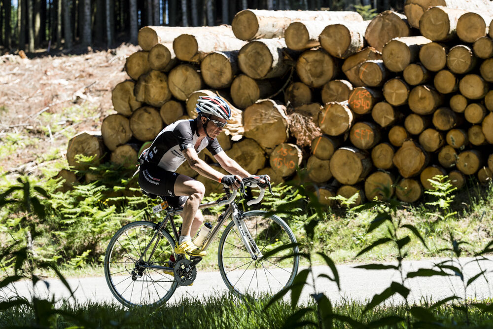
Cestný bicykel
37,73
km
Naskenujte kód QR a spustite navigáciu v aplikácii bergfex

Turistika a stopovanie


Le Beaujolais Vert - Around the summits of Beaujolais - Loop 3.1
ťažké
Vzdialenosť
37,73
km
Trvanie
03:00
h
Ascent
696
hm
Hladina mora
450 -
854
m
Stiahnutie skladby
Le Beaujolais Vert - Around the summits of Beaujolais - Loop 3.1
ťažké
Cestný bicykel
37,73
km
Sporty side
Less than 40 km, but difficult, this route will delight experienced cyclists, lovers of steep climbs. Small gear ratios will be appreciated.
From the start of Claveisolles the road rises up to...
Opis
Sporty side
Less than 40 km, but difficult, this route will delight experienced cyclists, lovers of steep climbs. Small gear ratios will be appreciated.
From the start of Claveisolles the road rises up to Poule-les-Echarmeaux (final slope of 10%). All that remains is to climb the Cols des Aillets, then the Echarmeaux and above all the Croix d’Ajoux (final around 15%…). Reaching the Col de la Casse Froide is easy and the beautiful descent (6%) of 5 km is appreciated reaching the finish.
Tourism side
Haut-Beaujolais surprises with the contrasting beauty of its landscapes: steep-sided valleys, bocage plateaus, valleys furrowed by the meanders of rivers… It is one of the main peaks of the Rhône: Saint-Rigaud, the highest in the department at 1,012 m, visible from the intersection of the RD 139 and 645, the Tourvéon (949 m), wooded pyramid which captures the eye when climbing to Les Aillets or the rock of Ajoux (970 m), pedestal mineral, which offers a remarkable panorama of the Alps and the Massif Central.
Trasa
Église de Lafont
(545 m)
Miesto uctievania
3,6 km
La Nuizière d'En-Bas
(608 m)
Zúčtovanie
6,5 km
Église Saint-Martin
(577 m)
Miesto uctievania
10,1 km
La Buffaudière
(597 m)
Zúčtovanie
11,9 km
La Molière
(641 m)
Zúčtovanie
18,7 km
Église Sainte-Madeleine
(668 m)
Miesto uctievania
25,8 km
Valtorte
(656 m)
Zúčtovanie
34,0 km
Trasa
Le Beaujolais Vert - Around the summits of Beaujolais - Loop 3.1
ťažké
Cestný bicykel
37,73
km
Claveisolles
(460 m)
Dedina
0,0 km
Église de Lafont
(545 m)
Miesto uctievania
3,6 km
Lafont
(543 m)
Zúčtovanie
3,7 km
La Nuizière d'En-Haut
(616 m)
Zúčtovanie
5,6 km
La Nuizière d'En-Bas
(608 m)
Zúčtovanie
6,5 km
Les Trêves
(660 m)
Zúčtovanie
7,5 km
Les Fougères
(584 m)
Zúčtovanie
8,8 km
La Combe
(581 m)
Zúčtovanie
9,4 km
Poule-les-Écharmeaux
(579 m)
Dedina
9,9 km
Au Ricochet
(578 m)
Reštaurácia
10,0 km
Église Saint-Martin
(577 m)
Miesto uctievania
10,1 km
La Fabrique
(536 m)
Zúčtovanie
10,5 km
La Buffaudière
(597 m)
Zúčtovanie
11,9 km
Le Suchet
(649 m)
Zúčtovanie
13,2 km
Le Perron
(696 m)
Zúčtovanie
14,9 km
Les Écharmeaux
(708 m)
Zúčtovanie
16,8 km
La Molière
(641 m)
Zúčtovanie
18,7 km
Les Colombières
(654 m)
Susedstvo
19,4 km
Propières
(657 m)
Dedina
19,6 km
Le Paquier
(654 m)
Zúčtovanie
19,9 km
La Voisinée
(712 m)
Zúčtovanie
24,3 km
Chénelette
(661 m)
Dedina
25,1 km
Église Sainte-Madeleine
(668 m)
Miesto uctievania
25,8 km
Les Grand'Cours
(665 m)
Zúčtovanie
29,0 km
Casse Froide
(744 m)
Koridor/terén
33,1 km
Valtorte
(656 m)
Zúčtovanie
34,0 km
Plat des Granges
(522 m)
Zúčtovanie
36,7 km
Claveisolles
(460 m)
Dedina
37,6 km
Autor
Poskytuje Rhône Tourisme
Prehliadku Le Beaujolais Vert - Around the summits of Beaujolais - Loop 3.1 zabezpečuje outdooractive.com.
Zatiaľ žiadne recenzie
Obľúbené výlety v okolí
-
De l’Aze à l’Ergues - Beaujolais Vert - Claveisolles
svetloTuristika 13,0 km -
5,0
B3 Mountain Bike Tour from Beaujeu to St Didier/Beaujeu
ťažkéMountainbike 22,6 km -
Mont Brouilly, between vines and culture - Beaujolais - Saint-Lager
svetloTuristika 7,47 km -
B9 Mountain Bike Tour Marchampt
ťažkéMountainbike 19,8 km -
The Beaujolais vineyard - Beaujolais - Chiroubles
svetloTuristika 12,5 km -
M12 Mountain Bike Tour B2 from Monsols to Ouroux
ťažkéMountainbike 22,5 km -
M2 Mountain Bike Tour from St Bonnet to St Christophe
ťažkéMountainbike 35,6 km -
VTT M9 circuit from propières to Azolette
ťažkéMountainbike 20,4 km -
M5 Mountain Bike Tour from Trades to St. Christopher
ťažkéMountainbike 16,5 km -
Trail of Mont Saint-Rigaud - Beaujolais - Deux-Grosnes
ťažkéTrailrunning 15,5 km
Turistika a stopovanie

Viac ako 550.000 návrhov výletov, podrobné mapy a intuitívny plánovač trás robia z aplikácie povinnú výbavu pre všetkých nadšencov prírody.

Nenechajte si ujsť ponuky a inšpiráciu na ďalšiu dovolenku
Prihlásiť sa k odberu noviniek
Chyba
Vyskytla sa chyba. Prosím, skúste to znova.
Ďakujeme za vašu registráciu
Vaša e-mailová adresa bol pridaný do poštového zoznamu.
Zájazdy po celej Európe
Rakúsko
Švajčiarsko
Nemecko
Taliansko
Slovinsko
Francúzsko
Holandsko
Belgicko
Poľsko
Lichtenštajnsko
Česko
Slovensko
španielsko
Hrvaška
Bosna a Hercegovina
Luxembursko
Andorra
Portugalsko
Island
Spojené kráľovstvo
Írsko
Grécko
Albánsko
Severné Macedónsko
Malta
Nórsko
Čierna Hora
Moldavsko
Kosovo
Maďarsko
San Maríno
Rumunsko
Estónsko
Lotyšsko
Bielorusko
Cyprus
Litva
Srbsko
Bulharsko
Monako
Dánsko
Švédsko
Fínsko