Replanette Loop Trail
svetlo
Získajte túto prehliadku v mobilnom telefóne
Replanette Loop Trail
svetlo
Trailrunning
10,98
km
Naskenujte kód QR a spustite navigáciu v aplikácii bergfex

Turistika a stopovanie


Replanette Loop Trail
svetlo
Vzdialenosť
10,98
km
Trvanie
02:20
h
Ascent
551
hm
Hladina mora
1 906 -
2 485
m
Stiahnutie skladby
Replanette Loop Trail
svetlo
Trailrunning
10,98
km
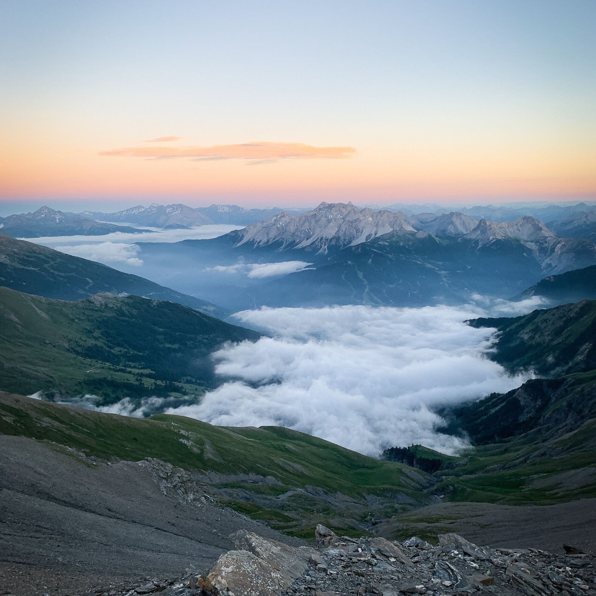
Follow the emblematic GR®5 as it crosses a well-marked high altitude meadow in the midst of the occasional herds. Its regular profile gives you easy access to the narrow valley junction at 2434 m altitude....
Opis
Follow the emblematic GR®5 as it crosses a well-marked high altitude meadow in the midst of the occasional herds. Its regular profile gives you easy access to the narrow valley junction at 2434 m altitude. Now you're immersed in a high-mountain world much appreciated by backpackers. Will you decide to extend your escapade as far as the Thabor refuge?
If you feel like it, why not take a trip to the Sainte-Marguerite lakes? They invite you to take a refreshing break and punctuate your ascent. A string of peaks protects the area. From the Pointe des Sarrasins to the peaks of the Three Wise Men - Balthazar, Melchior and Gaspard - via the Thabor, birds of prey have made this their kingdom.
On the way back, complete the itinerary with the Col de la Vallée Étroite at 2438 m altitude. This is one of the oldest traditional crossings between the Maurienne and Italian Piedmont. Can't you just feel the border? Bardonnechia and the Hautes-Alpes department are just a few steps away.
The Replanette balcony now offers an easy-to-cross ridge. The whistling of marmots echoes and accompanies you all the way to La Losa. When you arrive at the Lavoir, you'll be asking for more!
Trasa
Le Lavoir
(1 918 m)
Zúčtovanie
0,0 km
Refuge du Mont Thabor
(2 502 m)
Úkryt
5,3 km
Le Lavoir
(1 918 m)
Zúčtovanie
10,9 km
Trasa
Replanette Loop Trail
svetlo
Trailrunning
10,98
km
Autor
Poskytuje Haute Maurienne Vanoise
Prehliadku Replanette Loop Trail zabezpečuje outdooractive.com.

Informácie o trase
Trasa
To guide you in the field, consult the "step-by-step" directional diagram provided in pdf.
Jednosmerná prehliadka
Áno
Ďalšie informácie a tipy
Ďalšie informácie
1/ How is trail running time calculated? Trail times are calculated on the basis of reference paces for a regular runner who practices running on average 1 or 2 times a week. 600m/h ascent in altitude 900m/h ascent on descent 9km/h on the flat
2/ Using GPX tracks As hazards may occur at any time on the routes, the GPX tracks provided are not contractual. They are given for information only. Riders use them at their own risk, depending on their level of technological proficiency and their understanding of the terrain.
2/ Using GPX tracks As hazards may occur at any time on the routes, the GPX tracks provided are not contractual. They are given for information only. Riders use them at their own risk, depending on their level of technological proficiency and their understanding of the terrain.
Zatiaľ žiadne recenzie
Obľúbené výlety v okolí
-
4,5
BARDONECCHIA Pian del Colle - Valle Stretta
strednáSnežnice 5,02 km -
5,0
BARDONECCHIA Colle Sommeiller
strednáMountainbike 25,4 km -
5,0
BARDONECCHIA Green Lake
svetloTuristika 2,14 km -
5,0
BARDONECCHIA Forte Jafferau Loop
ťažkéMountainbike 36,8 km -
4,5
BARDONECCHIA Walter Bonatti Path - Grange della Rho
strednáTuristika 6,06 km -
5,0
BARDONECCHIA Col des Acles - Passo della Mulattiera
strednáTuristika 6,23 km -
BARDONECCHIA Lago Verde
svetloMountainbike 10,7 km -
BARDONECCHIA Monte Jafferau
ťažkéTuristika 11,6 km -
GR® 57 Tour de la Haute-Clarée
strednáTuristika 87,3 km -
4,0
BARDONECCHIA Sentiero dei Cosetti by Luciano Ferraris
svetloTuristika 3,24 km
Turistika a stopovanie

Viac ako 550.000 návrhov výletov, podrobné mapy a intuitívny plánovač trás robia z aplikácie povinnú výbavu pre všetkých nadšencov prírody.

Nenechajte si ujsť ponuky a inšpiráciu na ďalšiu dovolenku
Prihlásiť sa k odberu noviniek
Chyba
Vyskytla sa chyba. Prosím, skúste to znova.
Ďakujeme za vašu registráciu
Vaša e-mailová adresa bol pridaný do poštového zoznamu.
Zájazdy po celej Európe
Rakúsko
Švajčiarsko
Nemecko
Taliansko
Slovinsko
Francúzsko
Holandsko
Belgicko
Poľsko
Lichtenštajnsko
Česko
Slovensko
španielsko
Hrvaška
Bosna a Hercegovina
Luxembursko
Andorra
Portugalsko
Island
Spojené kráľovstvo
Írsko
Grécko
Albánsko
Severné Macedónsko
Malta
Nórsko
Čierna Hora
Moldavsko
Kosovo
Maďarsko
San Maríno
Rumunsko
Estónsko
Lotyšsko
Bielorusko
Cyprus
Litva
Srbsko
Bulharsko
Monako
Dánsko
Švédsko
Fínsko