Circuit "Le grand 8"
ťažké
Získajte túto prehliadku v mobilnom telefóne
Circuit "Le grand 8"
ťažké
Turistika
23,26
km
Naskenujte kód QR a spustite navigáciu v aplikácii bergfex

Turistika a stopovanie


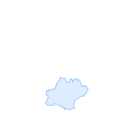

Circuit "Le grand 8"
ťažké
Vzdialenosť
23,26
km
Trvanie
05:45
h
Ascent
492
hm
Hladina mora
379 -
559
m
Stiahnutie skladby
Circuit "Le grand 8"
ťažké
Turistika
23,26
km
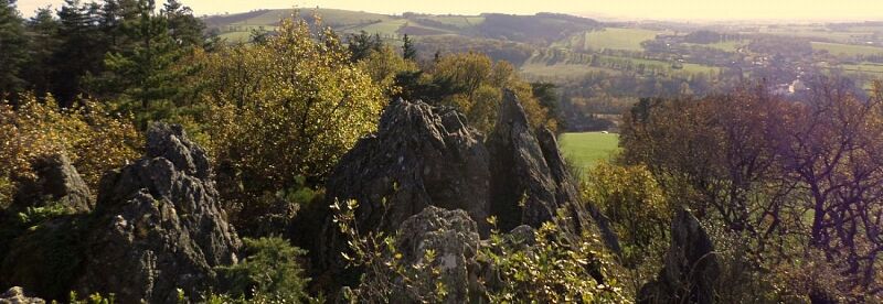
The Grand 8 route in Moularès offers 3 routes in 1. A lower loop of 10 km, an upper loop of 13 km, which together make up the large trail of 23 km. Bathed in the Ségala countryside, this hike winds along...
Opis
The Grand 8 route in Moularès offers 3 routes in 1. A lower loop of 10 km, an upper loop of 13 km, which together make up the large trail of 23 km. Bathed in the Ségala countryside, this hike winds along dry stone walls and among old trees. You can sometimes see cows.
Trasa
Église Notre-Dame-de-l'Assomption
(435 m)
Miesto uctievania
0,1 km
Moularès
(452 m)
Dedina
0,1 km
Poudac
(436 m)
Zúčtovanie
2,8 km
Bibel
(478 m)
Zúčtovanie
5,8 km
L'Hermet
(407 m)
Zúčtovanie
11,6 km
Bois de Lafon
(458 m)
Zúčtovanie
16,3 km
Bar
(494 m)
Zúčtovanie
19,5 km
Trasa
Circuit "Le grand 8"
ťažké
Turistika
23,26
km
Église Notre-Dame-de-l'Assomption
(435 m)
Miesto uctievania
0,1 km
Moularès
(452 m)
Dedina
0,1 km
Poudac
(436 m)
Zúčtovanie
2,8 km
Le Bruel
(462 m)
Zúčtovanie
4,6 km
Bibel
(478 m)
Zúčtovanie
5,8 km
Graummont
(439 m)
Zúčtovanie
9,1 km
L'Hermet
(407 m)
Zúčtovanie
11,6 km
Moureviel
(420 m)
Zúčtovanie
12,8 km
Bois de Lafon
(458 m)
Zúčtovanie
16,3 km
Le Soulié
(518 m)
Zúčtovanie
18,6 km
Bar
(494 m)
Zúčtovanie
19,5 km
Moularès
(452 m)
Dedina
23,2 km

Informácie o trase
Geologické zaujímavosti
Áno
Bezpečnostné pokyny
In case of emergency, dial 112
Informácie o príchode
Príchod
Consider carpooling
Parkovanie
Parking near the starting point
Ďalšie informácie a tipy
Ďalšie informácie
APIDAE Tourism data updated on 01/06/2021 by "Tourist Office of Ségala Tarnais".
An error on this sheet? Write to the owner referring to these details:
Sheet name: Circuit "Le grand 8" | Sheet ID: 5450973 | URL (link) of this Outdooractive page.
An error on this sheet? Write to the owner referring to these details:
Sheet name: Circuit "Le grand 8" | Sheet ID: 5450973 | URL (link) of this Outdooractive page.
Zatiaľ žiadne recenzie
Obľúbené výlety v okolí
-
5,0
Las Planques
ťažkéTuristika 17 km -
GR de Pays des Gorges du Viaur ®
ťažkéTuristika 65,3 km -
Sentier Pédestre l'Andouquette
ťažkéTuristika 7,81 km -
Heritage and Health Route
svetloTuristika 5,62 km -
Route no. 11 (red) MTB - Chasing the black diamond
ťažkéMountainbike 20,8 km -
Circuit no. 3 (black) MTB - The Raid of the Forgotten Cities
ťažkéMountainbike 26,1 km -
Circuit No. 2 (black) MTB - The Wild Escape
ťažkéMountainbike 25,2 km -
Tour du Tarn à cheval : Jouqueviel / Sainte-Gemme
ťažkéJazda na koni 25,0 km -
Bike route - C6 From the Ségala plateau to the Tarn valley
ťažkéCestný bicykel 70,6 km -
Circuit No. 6 (red) MTB - On the way to Navarre
ťažkéMountainbike 13,0 km

Turistika a stopovanie

Viac ako 550.000 návrhov výletov, podrobné mapy a intuitívny plánovač trás robia z aplikácie povinnú výbavu pre všetkých nadšencov prírody.

Nenechajte si ujsť ponuky a inšpiráciu na ďalšiu dovolenku
Prihlásiť sa k odberu noviniek
Chyba
Vyskytla sa chyba. Prosím, skúste to znova.
Ďakujeme za vašu registráciu
Vaša e-mailová adresa bol pridaný do poštového zoznamu.
Zájazdy po celej Európe
Rakúsko
Švajčiarsko
Nemecko
Taliansko
Slovinsko
Francúzsko
Holandsko
Belgicko
Poľsko
Lichtenštajnsko
Česko
Slovensko
španielsko
Hrvaška
Bosna a Hercegovina
Luxembursko
Andorra
Portugalsko
Island
Spojené kráľovstvo
Írsko
Grécko
Albánsko
Severné Macedónsko
Malta
Nórsko
Čierna Hora
Moldavsko
Kosovo
Maďarsko
San Maríno
Rumunsko
Estónsko
Lotyšsko
Bielorusko
Cyprus
Litva
Srbsko
Bulharsko
Monako
Dánsko
Švédsko
Fínsko