


Welterbesteig Oberes Mittelrheintal Trail Section 1 Bingen - Trechtingshausen

It's already off to a good startRight at the beginning at Bingerbrück station, it is almost impossible to resist the many impressions: the mouth of the Nahe, the Bingen Mäuseturm and the view of the monumental...
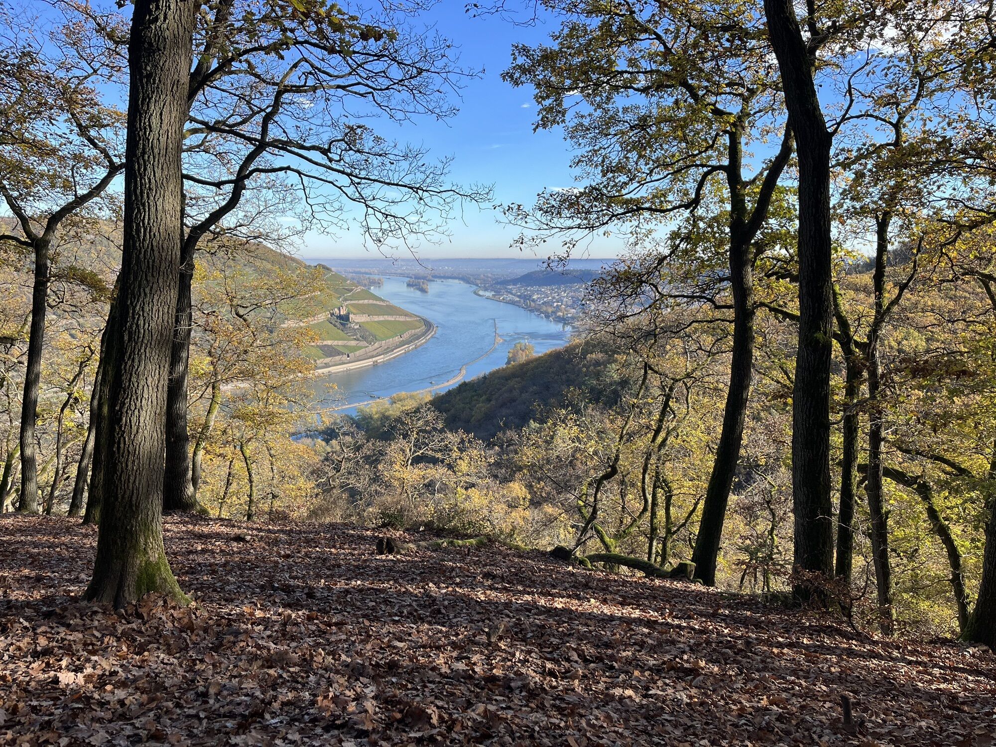
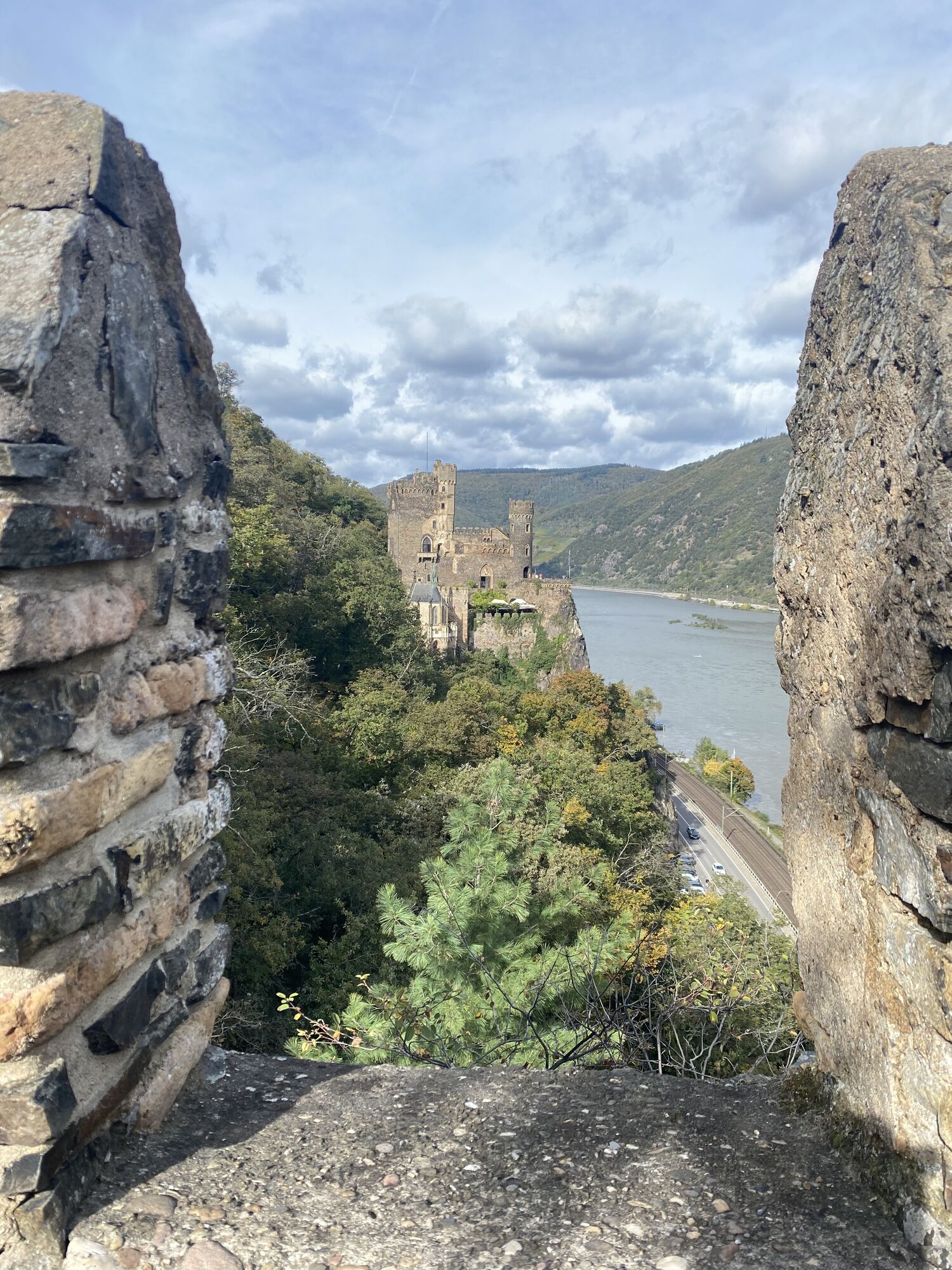
It's already off to a good startRight at the beginning at Bingerbrück station, it is almost impossible to resist the many impressions: the mouth of the Nahe, the Bingen Mäuseturm and the view of the monumental Niederwalddenkmal on the opposite side in the Rheingau. The part of the so-called Bingen Forest with its hardwoods is also impressive. The fact that its area stretches high into the Hunsrück is noticeable on the ascent.Shortly after the end of the Kreuzbachklamm gorge, the upper section of which you hike through, you realise that you are in the middle of a gorge: Hanging rope bridges are not only possible in the Hunsrück - even if in a much more reduced form. And you can reward yourself with a stop at the Heiligkreuz forester's lodge after just 5 km.The Schweizerhaus offers a seasonal beer garden with a view of the Rhine after a further 3 km hike at almost the same altitude. A watchtower further down the trail offers views back to the Binger Loch, to Assmannshausen opposite and to Rheinstein Castle, which invites you to visit directly along the trail.From here, the path climbs again in the direction of Morgenbach Valley. In terms of cultural history, a detour to Reichenstein Castle near Trechtingshausen rounds off the experience between (mind you) Rhine kilometres! 526 and 535 after about 11 km of hiking.
It's already off to a good startRight at the beginning at Bingerbrück station, it is almost impossible to resist the many impressions: the mouth of the Nahe, the Bingen Mäuseturm and the view of the monumental Niederwalddenkmal on the opposite side in the Rheingau. The part of the so-called Bingen Forest with its hardwoods is also impressive. The fact that its area stretches high into the Hunsrück is noticeable on the ascent.Shortly after the end of the Kreuzbachklamm gorge, the upper section of which you hike through, you realise: Hanging rope bridges are not only possible in the Hunsrück - even if in a much more scaled-down form. And you can reward yourself with a stop at the Heiligkreuz forester's lodge after just 5 km.The Schweizerhaus offers a seasonal beer garden with a view of the Rhine after a further 3 km hike at almost the same altitude. A watchtower further down the trail offers views back to the Binger Loch, to Assmannshausen opposite and to Rheinstein Castle, which invites you to visit directly along the trail.From here, the path climbs again in the direction of Morgenbach Valley. In terms of cultural history, a detour to Reichenstein Castle near Trechtingshausen rounds off the experience between (mind you) Rhine kilometres! 526 and 535 after about 11 km of hiking.
Good shoes and sufficient drinks are obligatory.
All starting points and destinations can be reached via the B9 on the left bank of the Rhine:Autobahn:Bingen: A 60 exit Bingen-OstBacharach: A 61 exit RheinböllenSt. Goar: A 61 exit EmmelshausenOberwesel: A 61 exit LaudertHirzenach: A 61 exit EmmelshausenBoppard: A 61 exit Boppard-BuchholzRhens: A 61 exit PaffenheckKoblenz: A 61, A 48
Since there is a railway station in almost every town on the left bank of the Rhine, the tours can be planned individually. This also makes it very easy to hike from a fixed location.For your orientation, here are the journey times between the individual stations by regional train:Bingen HbF - Techtingshausen: 4 min.Trechtingshausen - Niederheimbach: 4 min.Niederheimbach - Bacharach: 3 min.Bacharach - Oberwesel: 4 min. Oberwesel - St. Goar: 6 min.St. Goar - Hirzenach: 4 min.Hirzenach - Bad Salzig: 3 min.Bad Salzig - Boppard: 4 min.Boppard HbF - Spay: 5 min.Spay - Rhens: 3 min.Rhens - Koblenz HbF: 7 min.Bingen HbF - Koblenz HbF: 48 min.
Bacharach: On the B9 Rhine bank
Oberwesel: B9 town wall and Rhine bankSt. Goar: On the B9 Rhine bank
Hirzenach: Rheinstraße
Boppard: Marienberg parking deck, Remigiusplatz Mühltal
Rheinstein Castle directly on the Steig. Detour to Reichenstein Castle with a visit to the museum.
Obľúbené výlety v okolí
-
4,5
Durch den Kammerforst zum Teufelskadrich
svetloTuristika 12,3 km -
5,0
Traumschleifchen Pfalzblick
svetloTuristika 5,68 km -
4,8
Rund ums Niederwald Denkmahl
svetloTuristika 7,48 km -
5,0
Kaub - Bacharach - Clemenskapelle - Pfarrkirche St. Martin
strednádiaľková pešia trasa 13,8 km -
Wisper Trail Wispertalsteig
strednáTuristika 14,0 km -
4,5
Hiwweltour Bismarckturm
svetloTuristika 9,87 km -
5,0
Forsthaus Jägerhaus - Schlääfer Ruh - Forsthaus Heiligkreuz - Weiler bei Bingen
strednáTuristika 12,9 km -
4,0
Geisenheim, Marienthal, Winkel, Johannisberg
svetloTuristika 15,5 km -
Stadtmauerrunde BACHARACH
svetloTuristika 9,20 km -
4,0
Bike tour Upper Middle Rhine Valley World Heritage - South
strednáCyklistika 58,8 km
Turistika a stopovanie


Nenechajte si ujsť ponuky a inšpiráciu na ďalšiu dovolenku
Vaša e-mailová adresa bol pridaný do poštového zoznamu.