


Pfälzer Mandelpfad stage 04 Neustadt to Edenkoben
Welcome to the center of the Deutsche Weinstraße! From Neustadt’s city center, the path leads through the wine villages Hambach and Diedesfeld below the Hambacher Schloss, the "cradle of German democracy."...
Welcome to the center of the Deutsche Weinstraße! From Neustadt’s city center, the path leads through the wine villages Hambach and Diedesfeld below the Hambacher Schloss, the "cradle of German democracy." It continues through the vineyards and an almond tree avenue between the wine villages Maikammer and St. Martin. Numerous rest areas invite you to pause and relax.
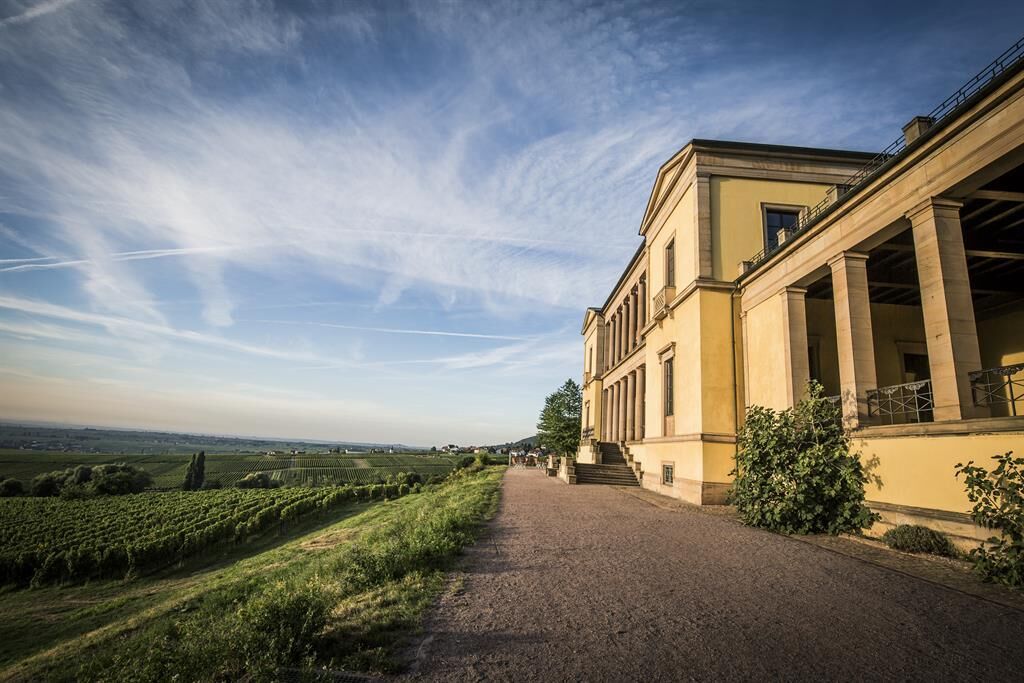
To the west rises the Victory and Peace Monument from the Palatinate Forest. It was built to commemorate the victory over the French in the war of 1870/71. Today, after years of peace and friendship with neighbors, it is only called the Peace Monument. Near the monument is recognizable the Villa Ludwigshöhe, the summer residence of King Ludwig I.
In Edenkoben, the path passes by the Museum of Viticulture and Local History to the end point of the stage.
The Mandelpfad passes directly by the most beautiful almond trees. Those who want to enjoy the sea of blossoms away from streets from above are on the right path on the Deutsche Weinstraße hiking trail.


The stage starts at the upper end of the pedestrian zone in Neustadt an der Weinstraße. A short stretch towards the station and then turn right over the railway tracks via the so-called Zwockelsbrücke. The Hambacher stairway leads up to Maxburgstraße. Following Maxburgstraße, the path reaches an intersection and turns right onto Weinstraße. After about 400 m, the Mandelpfad leaves Weinstraße and turns left onto Diedesfelder Weg, which leads out into the Neustadt vineyards. This path passes the outskirts of Neustadt-Hambach, the Hambach cemetery and the outdoor pool, crosses Mittelhambacher Straße, and then leads, parallel to Weinstraße, to Neustadt-Diedesfeld.
Follow Weinstraße to the town center and then turn right at the Diedesfeld community hall onto Zum Klausental. After passing the last houses of Diedesfeld, the Mandelpfad turns left and leads to the outskirts of Maikammer-Alsterweiler. Just before the development of the wine village begins, the path turns right. It continues zig-zagging through the large vineyard area "Mandelhöhe". The name recalls the field name "in den Mandeläckern" already mentioned in the 16th century. At that time, the Bishop of Speyer promoted the cultivation of almonds as an important fruit and had whole fields planted.
The path leads past the "Flurkreuz im unteren Grund" and the "Bildstock im Kalkofen," over a green strip between the vines to the Deutsche Weinstraße hiking trail, past a wonderful picnic spot with a fantastic view, to the Kalmithöhenstraße, which here is lined with pink-blossoming almond trees. Cross these, past the Alster fountain and over the Alsterweilerbach. Now it goes downhill with a beautiful view over the vineyards to Maikammer and into the Upper Rhine Graben through the vineyards, between the wine villages of Maikammer and St. Martin. Along this section, you can also admire white blossoming almond trees. Pass by a group of pink blossoming almond trees to the "Fünf Wunden Kreuz," and over Sankt-Martiner-Straße on the Zehnmorgenweg to the Kropsbach. Here the Mandelpfad turns right and follows the stream about 100 m to reach the bridge and cross the stream.
Then it goes straight uphill, following Dalbergweg through the vineyards. At Überfeldweg (tree with bench), the path turns left. A quick look back opens the view of Hambach Castle. To the west, the Kropsburg can be seen. The path continues eastwards. After about 500 m, it turns left and the next opportunity immediately right again. Straight ahead the path descends the Heiligenberg. On the field path running parallel to L512/Weinstraße, the Mandelpfad passes the cemetery and continues on Friedhofstraße to Edenkoben. A short stretch along Sankt-Martiner-Straße to Weinstraße and then straight on this into the town center, past the Museum of Viticulture and Local History, and down a traffic light intersection into the inner city, to the end of the stage at the Kurpfalzsaal.
We recommend for your hiking route:
- weatherproof clothing
- sturdy footwear, preferably hiking boots
- sufficient provisions for the day (food & drink)
(These are only recommendations, please check the weather conditions in advance!)
The vineyards are partly managed with large machines (harvesters, narrow-gauge tractors, etc.). There are many blind spots for the vehicle operator where hikers and other pedestrians as well as cyclists cannot be seen. Please pay attention to machine noises and behave cautiously and considerately.
Getting to Neustadt:
Coming from motorway A65:
- take the Neustadt Süd exit
- follow B39 towards Neustadt/station
The parking lot at the station (paid) is on the left side.
Alternative parking option: Festwiese parking lot (free of charge)
Getting to Edenkoben:
Coming from motorway A65:
- take the Edenkoben exit
- follow signs towards Edenkoben
- at the traffic light turn right onto Luitpoldstraße, after the traffic light continue on Klosterstraße
- turn left onto Radeburger Straße and at the end turn right onto Weinstraße
- at the roundabout take the 2nd exit onto Villastraße
Turn right onto Fritz-Claus-Weg, here is the parking lot.
You can check the route network and departure times of buses and trains at www.vrn.de or by calling: 01805 8764636.
The nearest stop to the start of the route: Neustadt station
The nearest stop to the end of the route: Edenkoben station
Neustadt:
- Parking at the station (paid)
- Festwiese parking lot (free of charge)
Edenkoben:
- Parking at Fritz-Claus-Weg
Want to learn more about the Pfälzer Mandelpfad and the surroundings of the individual routes?
Then you will find all information about the Mandelpfad, packages, and accommodations on the website: www.mandelbluete-pfalz.de and on the Facebook page: www.facebook.com/mandelbluete.pfalz .
Furthermore, if you have questions about this stage of the Mandelpfad, you can contact these tourist information offices:
Deutsche Weinstraße e.V. Mittelhaardt - Tel.: 06321/912333
Tourist Information Neustadt a.d. Weinstraße - Tel.: 06321/926892
Südliche Weinstraße e.V. - Tel.: 06341/940407
Südliche Weinstraße Maikammer e.V. - Tel.: 06321/952768
Tourist-Info St. Martin - Tel.: 06323/5300
Südliche Weinstraße Edenkoben e.V. - Tel.: 06323/959222
You will find dining and supply options along the route here!
Have fun!
You go high up from Villa Ludwigshöhe with the Rietburgbahn. From Rietburg, there is a wide view over the sea of vines.
Webové kamery z prehliadky
Obľúbené výlety v okolí
-
4,5
From Deidesheim over the Heidenlöcher to Eckkopf
strednáTuristika 14,6 km -
Wachenheim - Eckkopf - Heidenlöcher - Wachenheim
strednáTuristika 12,8 km -
5,0
Wachenheimer Valleys Route to Oppauer Haus
strednáTuristika 11,7 km -
4,0
Thomas‘ Waldweinstube über die Wachtenburg
svetloTuristika 4,81 km -
5,0
Palatinate Weinsteig Stage 08 Dernbach - Annweiler am Trifels
ťažkédiaľková pešia trasa 14,4 km -
5,0
Vom Hambacher Schloss auf die Kalmit
strednáTuristika 11,3 km -
5,0
Rundtour Roth unter Riethburg
strednáTuristika 14,5 km -
Neustadt, Kaltenbrunner Tal, Totenkopfhütte, Hellerhütte, Königsberg, Neustadt Neustadt an der Weinstraße, Rheinland-Pfalz
svetloTuristika 18,1 km -
Palatinate Wine Steig Stage 03 Bad Dürkheim - Deidesheim
strednádiaľková pešia trasa 15,2 km -
Palatinate Wine Route stage 05 Neustadt a. d. Weinstraße - St. Martin
ťažkédiaľková pešia trasa 19,8 km

Turistika a stopovanie


Nenechajte si ujsť ponuky a inšpiráciu na ďalšiu dovolenku
Vaša e-mailová adresa bol pridaný do poštového zoznamu.