


Around the castles
You will hike in the footsteps of history at Aubazine, Corrèze, Curemonte, Uzerche, the Tours de Merle, the Gallo-Roman site of Les Cars... and enjoy many exceptional viewpoints!
Sheltered by its three...
You will hike in the footsteps of history at Aubazine, Corrèze, Curemonte, Uzerche, the Tours de Merle, the Gallo-Roman site of Les Cars... and enjoy many exceptional viewpoints!
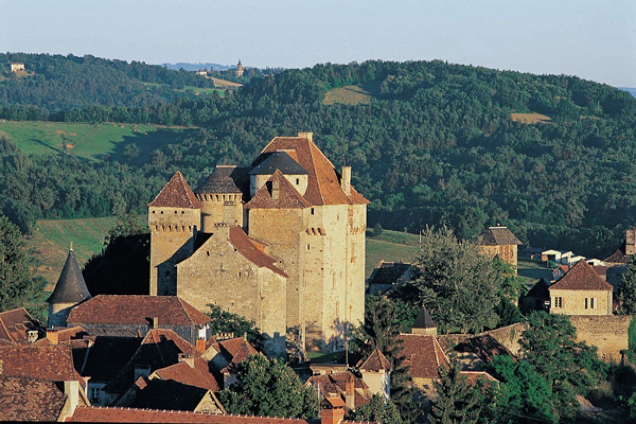
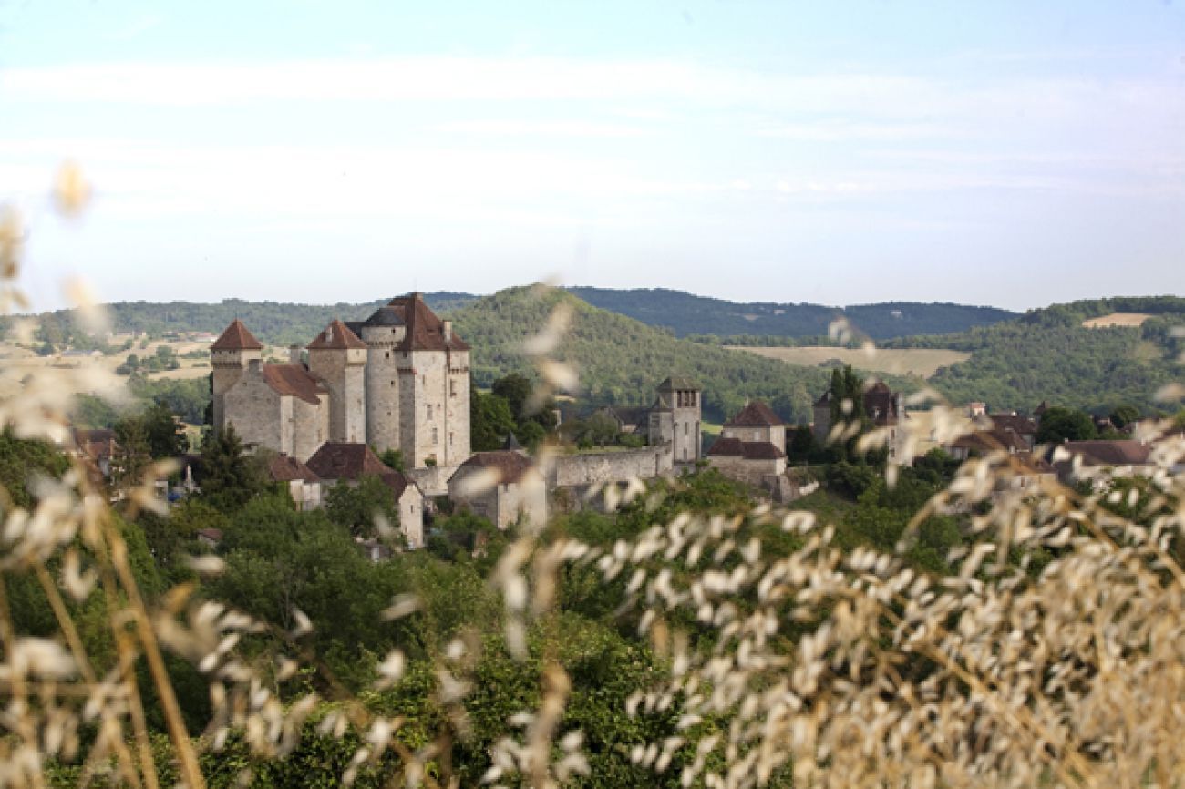
Sheltered by its three castles, the medieval village of Curemonte stretches along a ridge overlooking the valleys of the Sourdoire and the Maumont. This route will take you on a journey through history, thanks to its remarkable built heritage.
Genoese and flat tiles, gardens overlooking the valley, winegrowers’ houses, and sandstone buildings in harmony with the landscape mark the transition to Quercy.
Leave the village of Curemonte via D 106 (do not take the direction towards Branceilles), following the "all directions" sign.
Shortly before the cemetery, take a path on the right (view of Curemonte) and follow it to the market village.
At the first houses, follow the road to the left. Cross the D15 and continue straight ahead.
Before the bridge over the stream, take the first path on the right; climb back up to the D15 to Plaisance.
After the café-restaurant, follow the uphill path on the right and reach the road.
At Eymard, turn right onto the small road and reach the D106.
Take it to the left for 150 m (information sign on the left – view of Curemonte).
Take the path on the right (view of the Dordogne valley). Further on, cross a track and continue straight downhill to the Combe.
Turn left to join the D106, which is taken for 200 m to the Combe chapel.
Take a path to the right before the chapel, follow it straight leaving a path from the right, pass a pond. Take an ascending path.
At the crossroads, take the one on the right, steep and eroded. On the flat after a small house, follow the road to the right. At the road junction (reservoir, view of Curemonte), continue right for about 375 m.
At the intersection, at the height of the orientation table (view of the valleys of the Sourdoire, Maumont, Dordogne and beyond to the causses of Gramat and Martel), take the road to the left and return to the starting point.
Áno
Clothing adapted to the season and conditions (cold, hot, humid…)
Hiking shoes suited to the terrain (even for children!)
Hiking poles (useful for stability and to relieve joints)
Mobile phone and spare battery
Before setting off:
Check the general and local weather, ensuring no precipitation Inform yourself about the approach walk, itinerary elevation, duration, possible escape routes (IGN map, GPS, guidebook, etc.) Assess possible risks by consulting mountain professionals, refuges, lodgings Inform a close contact of your plan and update them if changes occur: departure and return times, number of participants with each phone number, vehicle(s), parking Avoid going alone, use equipment suitable for the activity, adjusted and in good condition, headlamp, complete first aid kit, survival blanket, etc.In case of trouble
Alert: call 112 (European emergency number)
5 key points to give in your alert:
Where? municipality, place, itinerary, altitude Who? identity, phone number What? type of accident, number of victims, severity, fall dynamics When? time of the accident Weather? wind, visibilityAccess to the starting point: reach the small square at the top of the village of Curemonte.
Parking available near the starting point.
Please respect traffic rules.
Corrèze Tourism
45 Quai Aristide Briand,
19000 Tulle
Obľúbené výlety v okolí
-
The most beautiful Corrèze villages... and the most beautiful climbs
ťažkéCestný bicykel 74,3 km -
Randonnée
svetloTuristika 11,8 km -
GR® de Pays du Midi Corrézien
strednádiaľková pešia trasa 117,8 km -
The Straw Wine and Castles Route
svetloCestný bicykel 18,0 km -
Leisure cycling route: the red stones
svetloCyklistika 14,2 km -
The Route of Castles and Wine
svetloCestný bicykel 34,0 km -
At the borders of Quercy
strednáMountainbike 15,4 km -
The picturesque Dordogne
svetloCestný bicykel 48,4 km -
The Roche de Vic Path
svetloMountainbike 16,4 km -
The Étang de Miel
svetloMountainbike 13,5 km
Turistika a stopovanie


Nenechajte si ujsť ponuky a inšpiráciu na ďalšiu dovolenku
Vaša e-mailová adresa bol pridaný do poštového zoznamu.