


The Glorious Return of the Waldensians Stage 6 | Prali - Bobbio Pellice
The ascent to Col Giulian, but above all the descent into the valley of the same name, are among the most difficult points of the route. For this reason, more than one alternative to the philological outline...
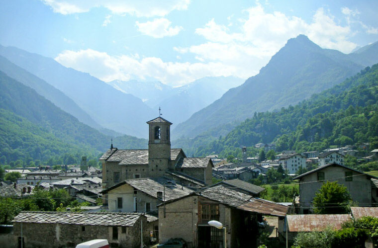
The ascent to Col Giulian, but above all the descent into the valley of the same name, are among the most difficult points of the route. For this reason, more than one alternative to the philological outline is offered. In any case, environments of severe beauty and authentic alpine wilderness are crossed. From the Giulian bergerie, the path becomes difficult to follow and it is very important to have a GPS track so as not to get lost (many trail signs are covered by tall grass). After passing the villages above Bobbio Pellice, you finally reach the monument of Sibaud. A stele was built here in 1889 which commemorates the Oath of Sibaud of 1 September 1689, with which the Waldensian exiles of the Glorious Repatriation first swore fidelity to God, then mutual obedience and loyalty between soldiers and officers, including the commander- pastor Henri Arnaud, to continue the fight towards freedom. Text taken from: www.lestradedeivaldesi.com

From the town, after the Ghigo di Prali bridge, follow the paved road. Leave the path that leads to the 13 lakes on the left and the entrance that leads to the campsite on the right a little further on. Shortly thereafter you reach a crossroads near Borgata Giordano, where the paved road ends and the dirt road begins. In this initial section the slope is felt in a discreet way. It passes through the hamlets of La Rabiera, l'Albergia, and continues on level ground up to Filharia and Selle da Val. Continue straight on ignoring the crossroads that leads to Miandette on the left. Shortly after Selle da Val, where an old wagon on a fenced stone wall represents the past reality of these areas, the cart track narrows to become a path. After a couple of streams you arrive at the Ponte del Rio, a large bridge that crosses an abundant stream. A few meters further on you come to a crossroads which leads to the right to Vallone delle Miniere and Passo di Brard and to the left to the path to Colle Giulian. Apart from the first stretch in the woods, the vegetation is abundant and invades the path several times. There are no more crossroads, except under the Colle where a path on the left leads to the Rics. Perrucchetti. The Colle is characteristic, partly on a dry stone wall, whose track to the right and relative signs indicate for Passo di Brard, Colle Gran Guglia and Lago Verde Refuge. While to continue towards Bobbio Pellice or even Villanova the descent is direct, frontal on Bergerie Giulian. From here, also the crossroads of the GTA dirt road that descends to Villanova, through the prairie, pasture area, diagonally halfway up the slope, you descend quickly, crossing various streams, including the Rio Brard which descends from the pass of the same name. Still halfway up in front of the Guglietta, the path loses height quickly until it reaches the only point where you need to be careful, due to the passage in a landslide area between two streams. From here the path enters the wood and halfway up the slope it continues fast up to Prapic. Continue up to Giaussaramont d'Amont where the path ends and the dirt road that leads to Serre Cruel begins; then the road becomes paved alternating with dirt roads up to Podio and from there to the stele of Sibaud to descend to Bobbio Pellice.
Warm and waterproof clothing, gloves, cap, sunglasses, rucksack, suitable footwear, poles (necessary), spare parts for staying in the refuge, sleeping bag, toiletry material.
A variant allows, using the 13 Lakes chairlift, to drastically reduce the difference in height. From the arrival point of the chairlift, proceed towards the 13 lakes and from there towards Col Giulian via a beautiful mule track. Once at the pass, the route rejoins the original route.
Obľúbené výlety v okolí
-
5,0
BOBBIO PELLICE Upslowtour - Ring 2 of the refuges
ťažkéCyklistika 37,6 km -
The Fort Roads - stage 11 from Massello to Prali
ťažkéPútnická trasa 13,7 km -
PRAROSTINO From Piani to Sonagliette and back - SLOWLY TOGETHER
svetloTuristika 6,60 km -
LUSERNA S.G. Upslowtour - Angrogna Valley Ring 11
strednáCyklistika 35,0 km -
VILLAR PELLICE Inverso path
svetloTuristika 5,62 km -
SAUZE DI CESANA Valle Argentera
strednáMountainbike 30,7 km -
TORRE PELLICE Hike to Bars d'la tajola (and Monte Castlus)
strednáTuristika 4,40 km -
PRALI Rocca Bianca Loop
ťažkéMountainbike 17,9 km -
BOBBIO PELLICE Trail of the Invincibles
strednáTuristika 19,1 km -
LUSERNA S.G. Upslowtour - Luserna Stone Loop 9
strednáCyklistika 38,1 km
Turistika a stopovanie


Nenechajte si ujsť ponuky a inšpiráciu na ďalšiu dovolenku
Vaša e-mailová adresa bol pridaný do poštového zoznamu.