


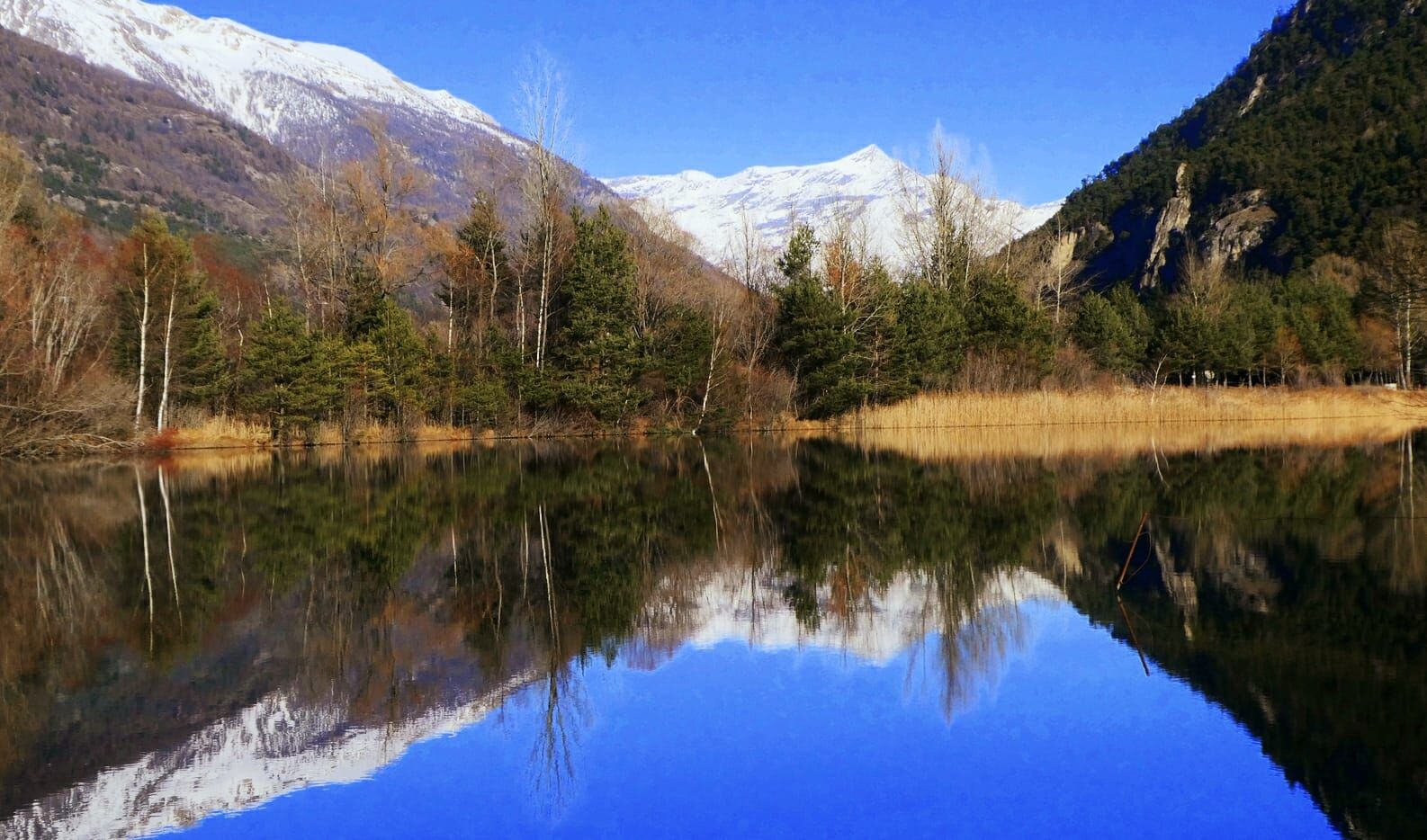
OULX Brue Longe (Lake Orfù)
Particularly close to the Gran Bosco Park and the Franchi Trail, Lake Orfu is a pleasant destination in every season. In winter especially, the snow-capped peaks are reflected in the crystal-clear waters...
Particularly close to the Gran Bosco Park and the Franchi Trail, Lake Orfu is a pleasant destination in every season. In winter especially, the snow-capped peaks are reflected in the crystal-clear waters offering beautiful panoramas.
The trail that leads to it from Oulx is a pleasant walk in the woods with no particular difficulties. The elevation gain is minimal and the well-marked trail allows an easy and relaxing walk.
After a short uphill section, the trail continues along the hillside in the wood bordering the town of Oulx, then descends towards the Gad hamlet and proceeds through an alternation of meadows and wooded areas until reaching the lake.

Park in Piazza Garambois and head uphill towards the Old Village of Oulx. After a few hundred meters still in the lower part of the village, the road turns right. The trail starts shortly afterwards on the left. The first part of the trail alternates sections of gentle uphill and flat stretches until reaching the intersection with the Cotantin trail. Follow the Cotantin trail. After a short steep descent, upon reaching the flat area, turn left and at the fork take the rightmost trail until reaching the trail (on the left) that comes from the lower part of Gad. Continue left until you reach the lake.
Áno
Áno
Clothing and footwear suitable for the winter mountain environment: snowshoes or crampons (in case of compact or icy ground) – poles – ARVA, shovel and probe.
Before undertaking any hike it is advised to:
- check the weather and avalanche bulletins of ARPA Piemonte, http://www.arpa.piemonte.it/bollettini and inquire at local Tourism Offices, Ski Schools, or Alpine Guides.
- in case of significant avalanche danger, hiking is not recommended.
- the indicated trails are maintained exclusively by foot traffic: no mechanical maintenance or grooming service is provided, either daily or periodically.
- hiking activities in snowy environments require the use of electronic signaling and search systems as per Legislative Decree no. 40/2021 art. 26
- the difficulty rating indicated for each route can vary based on snow cover conditions
From Torino follow the signs for the Northern Ring Road towards Trafori - Frejus.
Exit at Oulx east and continue right towards the center of Oulx.
Train from Torino P.N to Bardonecchia, get off at the Oulx-Cesana-Claviere-Sestriere stop.
Piazza Garambois
Before undertaking any hike it is advised to check the weather bulletins or ask for information at local Tourism Offices. It is good practice not to hike alone and always inform someone of your destination.
Do not litter the environment but carry waste downhill, collecting any left by others.
The indicated times are approximate and may vary based on weather conditions and your abilities.
This route is part of the easily accessible trail network from the Sentiero Italia.
Take with you a backpack with water and food, as there are no refreshment points or fountains along the route unless you decide to detour towards the center of Gad.
Webové kamery z prehliadky

Obľúbené výlety v okolí
-
5,0
BARDONECCHIA Colle Sommeiller
strednáMountainbike 25,4 km -
5,0
BARDONECCHIA Forte Jafferau Loop
ťažkéMountainbike 36,8 km -
5,0
BARDONECCHIA Decauville
strednáTuristika 7,29 km -
5,0
BARDONECCHIA Col des Acles - Passo della Mulattiera
strednáTuristika 6,23 km -
5,0
SESTRIERE Monte Rognosa
ťažkéTuristika 6,42 km -
BARDONECCHIA Monte Jafferau
ťažkéTuristika 11,6 km -
BARDONECCHIA - Loop Colle della Scala - Col de Montgenèvre - Colle del Sestriere
ťažkéCestný bicykel 91,9 km -
5,0
CESANA T.SE Cesana - Fenils
svetloTuristika 4,60 km -
5,0
CESANA T.SE Thures - Cima Bosco
ťažkéSnežnice 3,94 km -
4,0
BARDONECCHIA Sentiero dei Cosetti by Luciano Ferraris
svetloTuristika 3,24 km

Turistika a stopovanie


Nenechajte si ujsť ponuky a inšpiráciu na ďalšiu dovolenku
Vaša e-mailová adresa bol pridaný do poštového zoznamu.